
Immense winter storm places 60% of U.S. under winter weather warnings or advisories – one of the greatest extents ever recorded
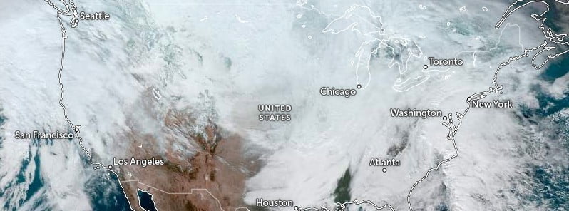
Image credit: NOAA/GOES-East, Zoom Earth, The Watchers
A multi-day historic winter storm is producing widespread disruptions to large portions of the U.S., placing over 200 million people, or roughly 60% of the U.S. population, under some form of winter weather warnings or advisories – one of the greatest extents of winter weather warnings and advisories ever.
“An immense winter storm that has brought a frigid blast to much of the CONUS along with impactful winter precipitation will persist in tracking across the eastern U.S. today,” NWS forecasters Oravec and Campbell noted.1
Winter weather hazards remain in effect from the Canadian border south to the Rio Grande, Gulf Coast and central Florida Peninsula while spanning from the Pacific Northwest to the Eastern Seaboard.
The National Weather Service’s Watch Warning graphic depicts one of the greatest extents of winter weather warnings and advisories ever, the forecasters said.
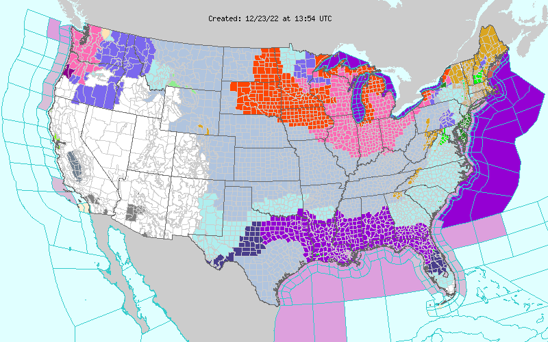
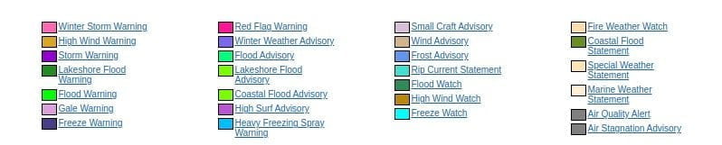
As of early Friday morning, December 23, over 240 million people in the United States are under some form of winter weather warning or advisory.
This includes 181 million for wind chill warnings or advisories, over 11 million for blizzard warnings, 58 million for winter storm warnings, and over 500 thousand for ice storm warnings.
Travel has already been affected by this storm along with reported power outages.
This system will have increasingly widespread impacts to travel going into the busy holiday travel time late this week, along with the potential for power outages from the expected high winds, heavy snows, significant icing and overall increased power consumption in places.
This powerful front allowed temperatures to plummet 17 – 28+ °C (30 to 50+ °F) over a short period for a vast portion of the country.
Widespread record low maximum temperature values are possible today from the Lower Mississippi Valley, northeastward into the Tennessee and Ohio Valleys and stretching across large sections of the east from the Southeast, through the Southern to Central Appalachians and into the Mid-Atlantic.
In addition to the very cold temperatures, high winds in the wake of the front will produce dangerous wind chill readings across nearly all of the central to eastern U.S.
A developing low pressure system along the arctic front over the Midwest/Great Lakes region will produce widespread heavy snows from portions of the Midwest into the Great Lakes on today.
Lakes Effect snowfall can be expected for the favored downwind locations of all of the Great Lakes on Saturday as the very cold arctic air streams across the Great Lakes.
Blizzard warnings and Winter Storm warnings are currently in effect from the Great Lakes, Mid West, Middle to Upper Mississippi Valley and into the Northern Plains.
Parts of the Pacific Northwest had icing late Thursday night that persisted into this morning as moisture from the Pacific falls into low level Arctic air currently entrenched across this area.
This low level arctic air is the western extent of the arctic airmass centered across the central portion of the nation. It does appear that this low level Arctic air over the Pacific Northwest will warm sufficiently by late Friday night along coastal sections to diminish the freezing rain threat.
The freezing rain threat will continue, however, inland through the Columbia River Valley and across areas east of the Cascades through much of Saturday, December 24.
References:
1 Short Range Forecast Discussion – NWS Weather Prediction Center College Park MD – 302 AM EST Fri Dec 23 2022
I'm a dedicated researcher, journalist, and editor at The Watchers. With over 20 years of experience in the media industry, I specialize in hard science news, focusing on extreme weather, seismic and volcanic activity, space weather, and astronomy, including near-Earth objects and planetary defense strategies. You can reach me at teo /at/ watchers.news.
Commenting rules and guidelines
We value the thoughts and opinions of our readers and welcome healthy discussions on our website. In order to maintain a respectful and positive community, we ask that all commenters follow these rules.