
State of emergency declared after rare EF-3 tornado hits Gaylord, Michigan

Image credit: Nicole Ann Boswood
A rare EF-3 tornado hit the city of Gaylord, Michigan on May 20, 2022, leaving extensive damage. One person was killed and at least 43 others were injured. Michigan Governor Gretchen Whitmer declared a state of emergency for the area. This is the first EF-3+ tornado to hit Michigan since March 2012.
Multiple thunderstorms tracked across northern Michigan Friday afternoon, May 20, including a supercell thunderstorm that produced the tornado that hit the town of Gaylord along with very large hail in other parts of the area, NWS said.1
Setting the stage for severe weather was a trough that rotated across the upper Midwest that developed and strengthened surface low pressure west of Lake Michigan.
This system helped draw a warm, moist airmass northward across the state that helped provide the instability necessary to support severe thunderstorms later in the day.
The tornado hit Gaylord (population 4 200) at 15:50 EDT, 12 minutes after NWS issued a tornado warning for the city.
It flipped vehicles, ripped roofs off buildings and downed trees and power lines, blocking roads, authorities said.2
One building appeared to be largely collapsed and a Goodwill store was badly damaged. A collapsed utility pole lay on the side of the road, and debris, including what appeared to be electrical wires and parts of a Marathon gas station, was scattered all along the street.
NWS meteorologist Jim Keysor said extreme winds are uncommon in that part of Michigan because the Great Lakes suck the energy out of storms, especially early in spring when the lakes are very cold.
The last time Gaylord had a severe wind storm was in 1998, when straight-line winds reached 160 km/h (100 mph).
The tornado touched down at 15:35 EDT about 9 km (6 miles) S of Elimar, Michigan in far eastern Antrim County.
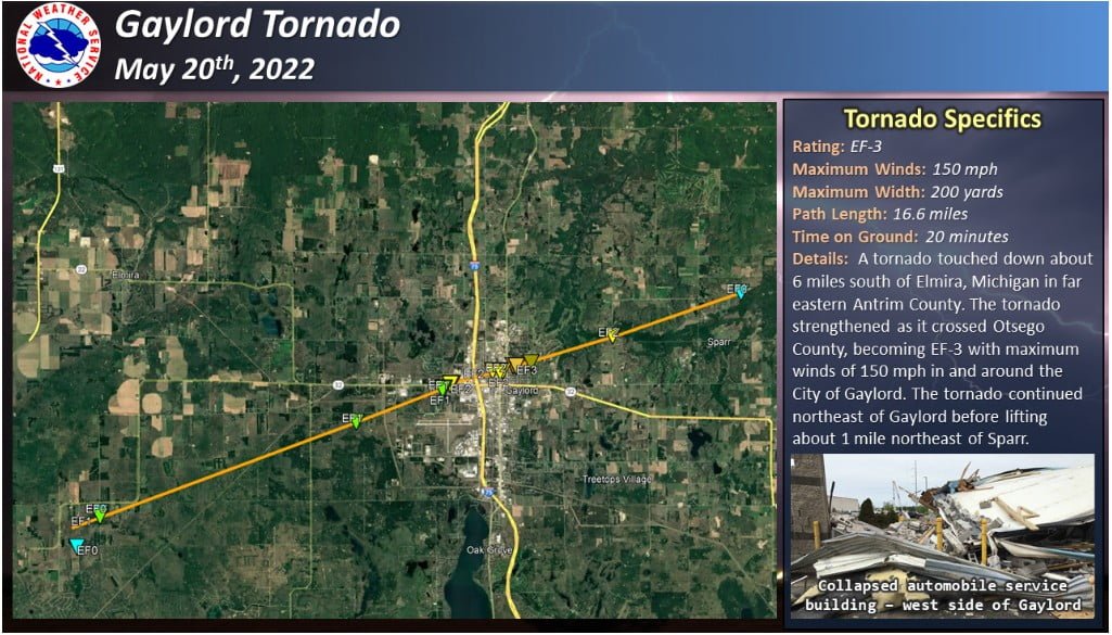
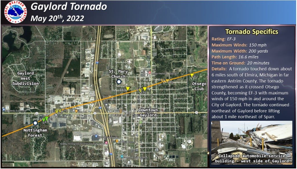
It strengthened as it crossed Otsego County, becoming EF-3 with maximum winds of 241 km/h (150 mph) in and around the City of Gaylord. The tornado continued northeast of Gaylord before lifting about 1.6 km (1 mile) northeast of Sparr at 15:50 EDT.
Its path length was 26.7 km (16.6 miles) and maximum width 182 m (200 yards).
This is the first EF-3+ tornado to hit Michigan since March 2012.


Large hail accompanied these storms with the largest hailstones ranging from the size of quarters (2.4 cm / 1 inch) to slightly larger than baseballs (7.6 cm / 3 inches).


References:
1 Recap of Severe Weather: May 20th, 2022
2 Rare tornado batters Michigan town – The West Australian – May 21, 2022
I'm a dedicated researcher, journalist, and editor at The Watchers. With over 20 years of experience in the media industry, I specialize in hard science news, focusing on extreme weather, seismic and volcanic activity, space weather, and astronomy, including near-Earth objects and planetary defense strategies. You can reach me at teo /at/ watchers.news.
Commenting rules and guidelines
We value the thoughts and opinions of our readers and welcome healthy discussions on our website. In order to maintain a respectful and positive community, we ask that all commenters follow these rules.