
Hurricane “Rick” forecast to make landfall over Mexico near or at major hurricane strength

Featured image: Hurricane "Rick" at 13:00 UTC on October 23, 2021. Credit: NOAA/GOES-East, RAMMB/CIRA, TW
Tropical Storm "Rick" formed at 21:00 UTC on October 22, 2021, as the 17th named storm of the 2021 eastern Pacific hurricane season and strengthened into a hurricane at 12:00 UTC today, becoming the 8th hurricane of the season. Rick is forecast to approach the coast of Mexico on Sunday and Sunday night, October 24, possibly as a major hurricane.
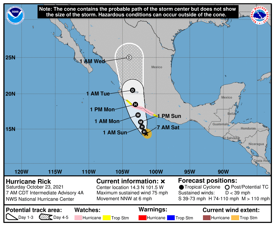
At 12:00 UTC on October 23, the center of Hurricane "Rick" was located about 380 km (235 miles) S of Zihuatanejo and 600 km (375 miles) SSE of Manzanillo, Mexico. It had maximum sustained winds of 120 km/h (75 mph), minimum central pressure of 990 hPa, and was moving NNW at 9 km/h (6 mph).1
A Hurricane Watch is in effect for Tecpan de Galeana to Punta San Telmo. A Tropical Storm Watch is in effect for areas east of Tecpan de Galeana to Acapulco; and west of Punta San Telmo to Manzanillo.
A north-northwestward to northward motion is expected over the next couple of days, bringing Rick near the coast of Mexico on Sunday and Sunday night (LT).
Rapid strengthening is forecast during the next day or so, and Rick is expected to become a major hurricane on Sunday.
Hurricane conditions are possible within the Hurricane Watch area by late Sunday, with tropical storm conditions possible by Sunday afternoon. Tropical storm conditions are possible within the Tropical Storm Watch areas by Sunday afternoon.
A storm surge is expected to produce significant coastal flooding in areas of onshore winds near and to the east of where the center of Rick makes landfall in southwestern Mexico. Near the coast, the surge will be accompanied by large and destructive waves.
Rick is expected to produce 125 to 250 mm (5 to 10 inches) of rain with isolated storm total amounts of 380 mm (15 inches) across coastal sections of the Mexican states of Guerrero and Michoacan from tonight through Tuesday. This heavy rainfall will likely produce flash flooding and mudslides.
Swells generated by Rick will begin to affect portions of the southwestern coast of Mexico later today. These swells are likely to cause life-threatening surf and rip current conditions.
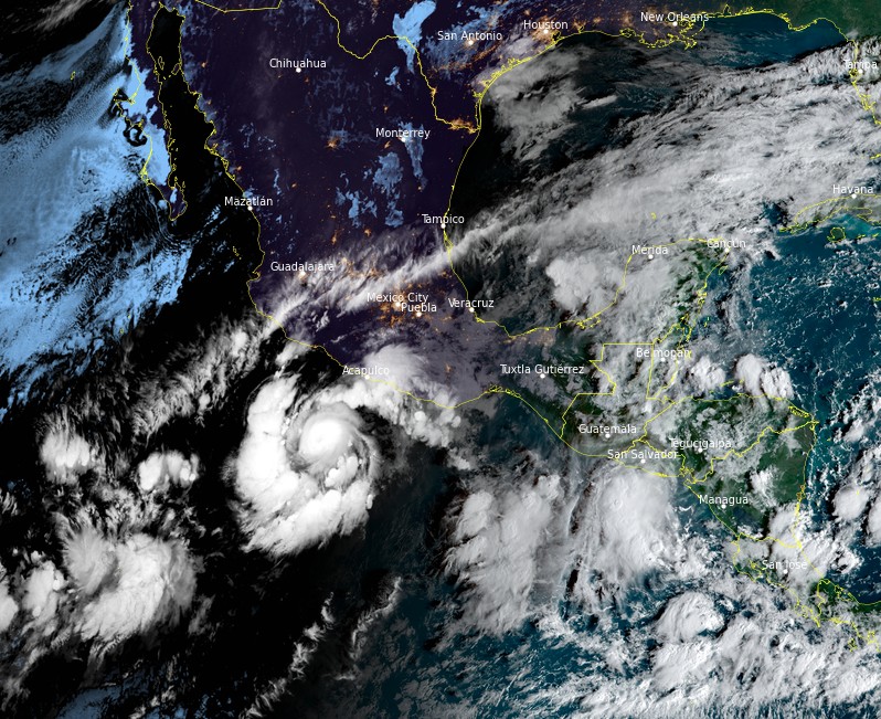
Image credit: NOAA/GOES-East, RAMMB/CIRA, TW
NHC key messages
Rick is expected to be at or near major hurricane strength when it reaches the coast of southern Mexico by Sunday night or Monday, and life-threatening storm surge and dangerous hurricane-force winds are possible within the Hurricane Watch area from Tecpan de Galeana to Punta San Telmo. There is larger-than-normal uncertainty in the track forecast of Rick, and the arrival time of hazardous conditions within the watch area could change significantly with future forecasts. Residents in this area should follow any advice given by local officials and check updates to the forecast.2
Rick could bring tropical storm conditions to portions of the southern and southwestern coasts of Mexico as early as Sunday from east of Tecpan de Galeana to Acapulco, and by Monday morning from west of Punta San Telmo to Manzanillo, where a Tropical Storm Watch is in effect.
Heavy rains associated with Rick are expected to move into the Mexican states of Guerrero and Michoacan starting tonight, and could persist through Monday night. This rainfall will likely produce flash flooding and mudslides.
References:
1 BULLETIN – Hurricane Rick Intermediate Advisory Number 4A – NWS National Hurricane Center Miami FL EP172021 – 700 AM CDT Sat Oct 23 2021
2 Tropical Storm Rick Discussion Number 4 – NWS National Hurricane Center Miami FL EP172021 – 400 AM CDT Sat Oct 23 2021
I'm a dedicated researcher, journalist, and editor at The Watchers. With over 20 years of experience in the media industry, I specialize in hard science news, focusing on extreme weather, seismic and volcanic activity, space weather, and astronomy, including near-Earth objects and planetary defense strategies. You can reach me at teo /at/ watchers.news.
Commenting rules and guidelines
We value the thoughts and opinions of our readers and welcome healthy discussions on our website. In order to maintain a respectful and positive community, we ask that all commenters follow these rules.