
Heavy snow and flash flood threats continue across the western U.S. – severe thunderstorms possible across West Texas and Eastern New Mexico
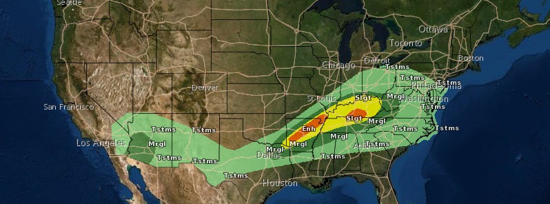
Image credit: NWS
Storm systems across the western U.S. will continue to bring heavy rainfall to portions of the Desert Southwest on Friday, March 13, 2020, with heavy snows continuing across many mountainous areas through the weekend. Heavy snow is also possible across the Central Plains into Saturday, with a few severe thunderstorms possible across West Texas and Eastern New Mexico.
A low pressure system is expected to slowly move across the Four Corners region eastward into the Southern Plains for the end of the week ahead of an upper-level trough, spreading precipitation to those areas, NWS forecaster Tate noted early March 13.
Heavy rain could continue during the day today for the Southwest before winding down tonight, and Flash Flood Watches remain in effect there.
Rain and thunderstorms should spread into the Southern Plains today as well, and there is a Slight Risk of severe weather in effect for parts of southeastern New Mexico and western Texas, along with the potential for a couple of inches of rain in Oklahoma.
Farther east, a slowly moving front across the Lower Mississippi Valley and Southeast will lead to rain for those areas and into the Tennessee and Lower Ohio Valleys.
Currently, over 25 mm (1 inch) of rain is forecast for portions of Tennessee and Kentucky on Saturday, March 14, which could cause isolated flooding.
As a strong high-pressure system presses southward through western Canada, snow is expected to spread ahead of it into the Northern High Plains.
Upper-level energy and the aforementioned low pressure system should also lead to snow developing in the Central Rockies and into the Central Plains.
Persistent snowfall across the Northern Great Basin, Northern Rockies, and Northern High Plains through Sunday morning, March 15, should create snowfall totals of 30 to 45 cm (1 foot to 18 inches) in those areas.
Snow in the Central Plains looks to begin Friday evening and wind down on Saturday, and snowfall amounts of over 15 cm (6 inches) are forecast there, Tate said.
An upper-level low is forecast to spin offshore in the Eastern Pacific Saturday into Sunday, leading to multiple rounds of precipitation for the Pacific Northwest into the Intermountain West and California.
Heavy snow is possible for the Cascades and the Sierra Nevada.
Elsewhere, a frontal system is expected to pass through the Mid-Atlantic and Northeast today, leading to rain in the bulk of those areas but snow in far northern New England. Over 15 cm (6 inches) of snow is possible in far northern Maine, along with light freezing rain in northern Vermont and New Hampshire and western Maine.
The cold high-pressure system will bring much below normal temperatures to the Northwest through the end of the week.
Below-average temperatures (5 to 14 °C / 10 to 25 °F below normal for highs) are also forecast for the Central High Plains today, spreading into the Middle Mississippi Valley toward the Ohio Valley Saturday.
Meanwhile, south of the front, the Gulf Coast states will be warmer than normal.
The Eastern Seaboard can expect warm weather today, with highs in the 70s (°F) [20 – 27 °C] for the Mid-Atlantic and in the 60s (°F) [15 – 20 °C] for southern New England, but should cool to near normal Saturday after the cold front passes.
I'm a dedicated researcher, journalist, and editor at The Watchers. With over 20 years of experience in the media industry, I specialize in hard science news, focusing on extreme weather, seismic and volcanic activity, space weather, and astronomy, including near-Earth objects and planetary defense strategies. You can reach me at teo /at/ watchers.news.
Commenting rules and guidelines
We value the thoughts and opinions of our readers and welcome healthy discussions on our website. In order to maintain a respectful and positive community, we ask that all commenters follow these rules.