Major storm to race coast-to-coast this weekend, followed by another cold blast, US

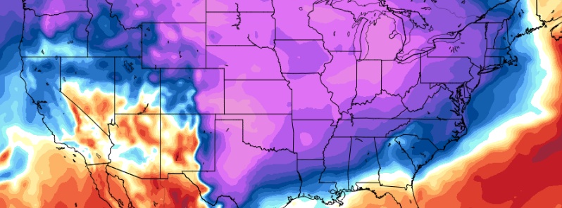
A major winter storm with an array of hazards will impact much of the country this weekend, the National Weather Service warns. The storm will cross California, the Great Basin and central Rocky Mountains today, March 2 delivering heavy rain to lower elevations and heavy snow to the mountains. It will then quickly shift across the eastern half of the country on Sunday, March 3 with areas of heavy snow, heavy rain and severe thunderstorms. This event is followed by another blast of frigid Arctic air which will bring temperatures up to 28 °C (50 °F) below average for the time of the year over the Northern Plains into the Central Plains.
Upper-level energy moving onshore over California will move eastward to off the Northern Mid-Atlantic Coast by Monday, March 4. The storm will produce rain and higher elevation snow over California and rain/snow over parts of the Great Basin through Sunday morning, NWS forecaster Ziegenfelder notes.
Snow will move into the Central Rockies on Saturday and developing over parts of the Northern/Central Plains by Saturday evening.
The snow will expand into parts of the Southern Plains and Middle Mississippi Valley overnight Saturday continuing to march eastward into the Ohio Valley on Sunday.
On Sunday afternoon, the snow will develop over parts of the Mid-Atlantic. It will enter into New England and the Northern Appalachians overnight Sunday and continue over the Northeast into the Northern Mid-Atlantic through Monday morning.
As the upper-level energy moves out of the Rockies, moisture from the Western Gulf of Mexico will stream northward over the Southern Plains into the Lower Mississippi Valley and continue eastward then move off the Southeast Coast by Sunday evening.
The moisture will aid in producing showers and thunderstorms over parts of the Western Gulf Coast by Saturday evening expanding into the Lower Mississippi Valley by Sunday morning.
On Sunday, the showers and thunderstorms will move into the Southeast and off the Southeast Coast by Monday.
Elsewhere, onshore flow and weak upper-level impulses will aid in producing rain and higher elevation snow over parts of California into the Great Basin that will wane overnight Sunday.
The storm will be followed by a fresh blast of very cold Arctic air, bringing temperatures up to 28 °C (50 °F) below average for the time of the year over the Northern Plains into the Central Plains.
Featured image credit: GFS, TropicalTidbits

Commenting rules and guidelines
We value the thoughts and opinions of our readers and welcome healthy discussions on our website. In order to maintain a respectful and positive community, we ask that all commenters follow these rules.