
Widespread riverine flooding hits Trinidad and Tobago, heavy rain to last for days
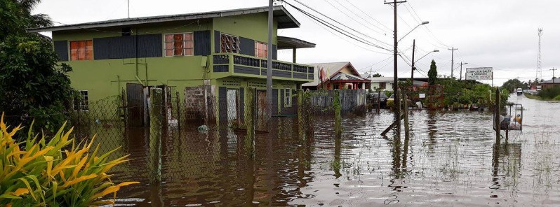
Featured image: widespread flooding across Woodland, South Trinidad. Credit: Mitra Jaglal
Heavy rain that started Wednesday, October 18, 2017 caused major floods in parts of Trinidad and Tobago, leaving numerous submerged homes, roads and farms and thousands of marooned citizens. The threat for moderate to heavy showers, additional flooding and landslides will continue across the country over the weekend and into next week.
The Trinidad and Tobago Meteorological Service is maintaining the riverine flood alert for Trinidad due to the rainfall activity associated with the Inter-Tropical Convergence Zone (ITCZ) over the last 48 hours, Met Office said in a bulletin issued 06:11 local time (10:11 UTC) today. As opposed to Street and Flash Flooding, Riverine Flooding is more prolonged and widespread, it said.
Reports from the Water Resources Agency indicate that water levels in some of the nation’s major rivers as well as their tributaries have reached threshold levels, including the Caroni River.
Citizens in general, and those residing in the Caroni River Basin in particular, are asked to be on the alert for high river levels and overspill in some areas. All necessary measures MUST be taken to preserve life and property.
"We strongly underscore that Trinidad and Tobago is not under any tropical storm threat, watch or warning at this time," the bulletin said.
Crops and livestock were lost and residents in all four corners of the country were left leaning up mud left by flood waters on Thursday, October 19, Trinidad and Tobago Newsday reported. The rain continued into Friday, causing damaging, widespread flooding.
While schools across Trinidad have not been officially canceled, the Minister of Education says that "Parents and principals need to look at flooding in their areas to determine whether students should attend their respective schools."
"Nearly 200 mm (7.87 inches) of rainfall has fallen across Trinidad over the last 48 hours," the Trinidad and Tobago Weather Center said on their Facebook page early Friday.
Rainfall Accumulations Between 12:00 Wednesday, October 18 and 12:00 Friday, October 20:
Brasso: 181.1 mm (7.12 inches)
Cipero Street, San Fernando: 169.4 mm (6.66 inches)
Chickland Village: 167.1 mm (6.57 inches)
Duncan Village, San Fernando: 149.9 mm (5.90 inches)
Freeport: 121.6 mm (4.78 inches)
Buen Intento, Princes Town: 113.5 mm (4.46 inches)
St Augustine: 109 mm (4.29 inches)
El Reposo, Sangre Grande: 106.2 mm (4.18 inches)
[Official] Piarco International Airport: 106 mm (4.17 inches)
Point Lisas: 93.7 mm (3.68 inches)
Carenage: 80.5 mm (3.16 inches)
Sahai Trace, Princes Town: 76.2 mm (3 inches)
Tragrete Road, Port of Spain: 52.9 mm (2.08 inches)
West Mall: 52.2 mm (2.05 inches)
Maraval: 42.9 mm (1.68 inches)
Tobago:
Bethany: 88.3 mm (3.47 inches)
[Official] A.N.R. Robinson International Airport: 34 mm (1.33 inches)
Note that these values are from the personal weather stations across Trinidad and Tobago that may or may not be properly configured. Piarco, ANR Robinson, El Reposo and Brasso stations are the Trinidad and Tobago Meteorological Service’s Automated Weather Stations. These values are preliminary and are likely to be updated as this flooding event continues throughout the weekend, TTWC said.
As of the latest satellite imagery at 03:30 AST, widespread, persisting showers are occurring over much of Trinidad with cloudy conditions occurring over Tobago. Showers are likely to persist through sunrise, exacerbating flooding conditions across the country, TTWC added.
Widespread showers are likely to persist across Trinidad with heavier showers affecting Eastern Trinidad and Tobago through the morning. By midday through the afternoon, moderate to heavy showers will continue to affect most of Trinidad with heavier showers affecting Eastern and Southern Trinidad as well as parts of Tobago.
These showers will decrease in intensity and coverage by nightfall but another round of showery activity is expected after 22:00 AST. Continuing riverine flooding is expected with flash flooding developing in areas of moderate to heavy showers. Landslides are possible in elevated areas.
Gusty winds are possible with gusts in excess of 70 km/h (43 mph), mostly favoring Northern Trinidad and Tobago. These gusts, coupled with saturated grounds increase the chances for downed trees and utility poles.
Additional widespread rainfall accumulations of 10 – 15 mm (0.39 – 0.59 inches) with isolated areas receiving between 20 – 40 mm (0.78 – 1.57 inches) are expected.
I'm a dedicated researcher, journalist, and editor at The Watchers. With over 20 years of experience in the media industry, I specialize in hard science news, focusing on extreme weather, seismic and volcanic activity, space weather, and astronomy, including near-Earth objects and planetary defense strategies. You can reach me at teo /at/ watchers.news.
Commenting rules and guidelines
We value the thoughts and opinions of our readers and welcome healthy discussions on our website. In order to maintain a respectful and positive community, we ask that all commenters follow these rules.