
Unusually large waterspout recorded off Port of Spain, Trinidad and Tobago

Image credit: Trinidad and Tobago Weather Center
An unusually large waterspout formed in the Gulf of Paria, off Port of Spain, Trinidad and Tobago at around 14:50 LT on Friday, December 19, 2020.
The waterspout remained out to the sea, as the thunderstorm it was attached to moved westward toward Venezuela.
No damage or casualties have been reported.

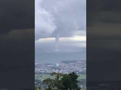




It's hard to say how frequently Trinidad and Tobago experiences waterspouts, as there really has been no good (or at least public) record-keeping of tornado or waterspout events across the country, the Trinidad and Tobago Weather Center said.
However, 'the December 2020 Gulf of Paria event is just one of many we’ve noticed in the last few years, likely due to an increase in persons with cameras near the coast.'
"We’re trying to build a database of these events, by scouring media reports dating back to the early 1900s to come up with how frequently these events occur and where have they occurred in the past.
"Tornadoes and waterspouts across Trinidad and Tobago remain a very uncommon feature, but due to a lack of technology to issue and disseminate timely warnings to the public, it is imperative you know what to do in the event one occurs."
The last recorded waterspout event was just a month ago in the Gulf of Paria, on November 18, 2020.

Teo Blašković founded The Watchers in 2011 and edited it until 2026, covering seismic and volcanic activity, extreme weather, space weather and near-Earth objects. Articles on this page are his archive.
Earlier reporting
Nothing on Watchers was published in the last 24 hours. These are older articles.
- On October 22, 2017, a single flash of lightning stretched 515 miles from eastern Texas to near Kansas City, a distance that takes eight hours to drive, and nobody realized how far it had gone until scientists went back through the satellite data years later Epicenter
- CPC posts a slight risk of heavy rain from the Gulf Coast to the Northeast urban corridor November 25-29, and a moderate risk of West Coast wind and Sierra snow on November 25
- Florida's east coast faces a moderate flash flood risk Wednesday through Friday, with 4 to 8 inches of rain forecast and the St. Johns River near Cocoa already in major flood at 17.13 feet
- Cyclone Akvan to make landfall between Nellore and Visakhapatnam around noon on November 20, IMD forecasts 120-130 km/h winds gusting to 145

Amazingly unusual occurence in this Tropical Paradise.
Wonders never cease.