
Category 5 Hurricane “Maria” hits Dominica, Puerto Rico bracing for catastrophic impact
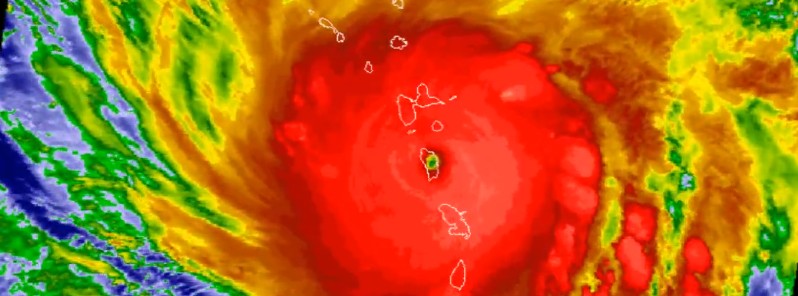
Featured image: Category 5 Hurricane "Maria" hits Dominica on September 19, 2017. Credit: NOAA-GOES16, NWS OPC
The eye of Category 5 Hurricane "Maria" was raging across Dominica for more than 2 hours on September 19, 2017, as the strongest storm to hit Dominica ever. It hit the country's southeast regions about 01:00 UTC (21:00 local time) with maximum sustained winds of 260 km/h (160 mph) and exited in its northwest after 03:00 UTC (23:00 local time). Although some fluctuations in intensity are likely over the next 24 – 48 hours, Maria is forecast to remain an extremely dangerous hurricane as it approaches the Virgin Islands and Puerto Rico.
"We do not know what is happening outside. We do not dare look out. All we are hearing is the sound of galvanizing flying. The sound of the fury of the wind, as we pray for its end," Dominica's Prime Minister Roosevelt Skerrit said in a Facebook post as the hurricane raged through the island. "My roof is gone. I am at the complete mercy of the hurricane. House is flooding," he posted soon after that, as he was waiting to be rescued.
"Initial reports are of widespread devastation," he said just before 06:00 UTC (02:00 local time). "So far we have lost all that money can buy and replace. My greatest fear for the morning is that we will wake to news of serious physical injury and possible deaths as a result of likely landslides triggered by persistent rains."
"The winds have swept away the roofs of almost every person I have spoken to or otherwise made contact with. The roof of my official residence was among the first to go and this apparently triggered an avalanche of torn away roofs in the city and the countryside," he said.
"Come tomorrow morning we will hit the road, as soon as the all clear is given, in search of the injured and those trapped in the rubble. I am honestly not preoccupied with physical damage at this time, because it is devastating…indeed, mind-boggling. My focus now is in rescuing the trapped and securing medical assistance for the injured.
We will need help, my friend, we will need help of all kinds.
It is too early to speak of the condition of the air and seaports, but I suspect both will be inoperable for a few days. That is why I am eager now to solicit the support of friendly nations and organizations with helicopter services, for I personally am eager to get up and get around the country to see and determine what's needed."
Charles Jong, PM's Head of Communications, said it feels like a tornado outside and an earthquake inside.
At this time (07:04 UTC / 03:00 local time), nobody in Dominica is allowed to go out.
At 06:00 UTC on September 19, the center of Hurricane "Maria" was located 70 km (45 miles) WNW of Dominica and 380 km (235 miles) SE of St. Croix. Its maximum sustained winds were 250 km/h (155 mph), which placed Maria on the upper edge of Category 4 hurricane. The system is moving WNW at a speed of 15 km/h (9 mph) with the minimum estimated central pressure of 942 hPa.
Some fluctuations in intensity are likely during the next day or two, but Maria is expected to remain an extremely dangerous Category 4 or 5 hurricane while it approaches the Virgin Islands and Puerto Rico.
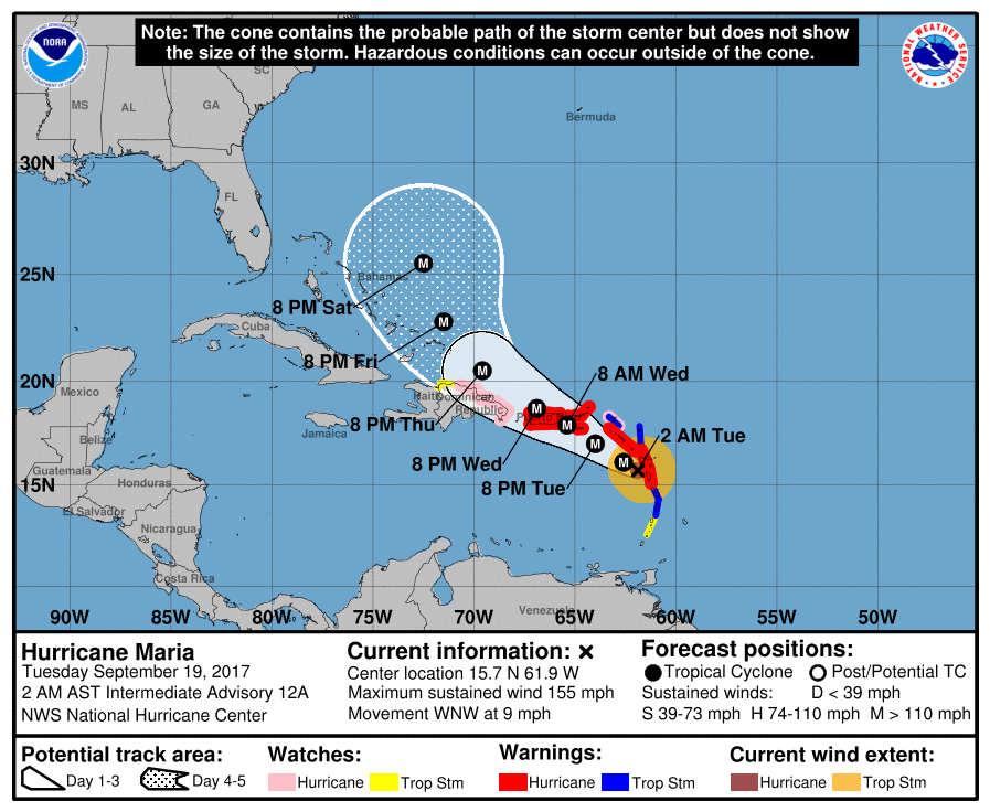
A Hurricane Warning is in effect for:
- Guadeloupe
- Dominica
- St. Kitts, Nevis, and Montserrat
- U.S. Virgin Islands
- British Virgin Islands
- Puerto Rico, Culebra, and Vieques
A Hurricane Warning means that hurricane conditions are expected somewhere within the warning area. Preparations to protect life and property should be rushed to completion.
A Tropical Storm Warning is in effect for:
- Antigua and Barbuda
- Saba and St. Eustatius
- St. Maarten
- Anguilla
- St. Lucia
- Martinique
A Tropical Storm Warning means that tropical storm conditions are expected somewhere within the warning area.
A Hurricane Watch is in effect for:
- Saba and St. Eustatius
- St. Maarten
- St. Martin and St. Barthelemy
- Anguilla
- Isla Saona to Puerto Plata
A Hurricane Watch means that hurricane conditions are possible within the watch area. A watch is typically issued 48 hours before the anticipated first occurrence of tropical-storm-force winds, conditions that make outside preparations difficult or dangerous.
A Tropical Storm Watch is in effect for:
- St. Vincent and the Grenadines
- West of Puerto Plata to the northern Dominican Republic-Haiti border
A Tropical Storm Watch means that tropical storm conditions are possible within the watch area, generally within 48 hours.
Interests elsewhere in Hispaniola, the southeastern Bahamas, and the Turks and Caicos Islands should monitor the progress of Maria. Additional watches and warnings may be required today.
Winds over Dominica are now diminishing. Hurricane conditions should spread throughout portions of the hurricane warning area in the Leeward Islands this morning. Hurricane conditions should spread through the remainder of the Hurricane Warning area later today and Wednesday. Hurricane conditions are possible within the Hurricane Watch area in the Dominican Republic late Wednesday, with tropical storm conditions possible by early Wednesday. Tropical storm conditions are possible in the Tropical Storm Watch area in St. Vincent and the Grenadines this morning, and are possible in the Tropical Storm Watch area in the Dominican Republic on Wednesday.
Wind speeds atop and on the windward sides of hills and mountains could be much stronger than the near-surface winds indicated in this advisory.
A dangerous storm surge accompanied by large and destructive waves will raise water levels by as much as 2.1 to 3.3 m (7 to 11 feet) above normal tide levels in the hurricane warning area near where the center of Maria moves across the Leeward Islands and the British Virgin Islands.
The combination of a dangerous storm surge and the tide will cause normally dry areas near the coast to be flooded by rising waters moving inland from the shoreline. The water is expected to reach the following heights above ground if the peak surge occurs at the time of high tide:
Puerto Rico and the U.S. Virgin Islands: 1.8 to 2.7 m (6 to 9 feet)
The deepest water will occur along the immediate coast near and to the north and east of the landfall location, where the surge will be accompanied by large and destructive waves. Surge-related flooding depends on the relative timing of the surge and the tidal cycle, and can vary greatly over short distances.
Maria is expected to produce the following rain accumulations through Thursday:
- Central and southern Leeward Islands: 254 to 381 mm (10 to 15 inches), isolated 508 mm (20 inches).
- U.S. and British Virgin Islands: 254 to 381 mm (10 to 15 inches), isolated 508 mm (20 inches).
- Puerto Rico: 304.8 to 457.2 mm (12 to 18 inches), isolated 635 mm (25 inches).
- Northern Leeward Islands from Barbuda to Anguilla: 101.6 to 203.2 mm (4 to 8 inches), isolated 254 mm (10 inches).
- Windward Islands and Barbados: 50.8 to 101.6 mm (2 to 4 inches), isolated 152.4 mm (6 inches).
- Eastern Dominican Republic: 101.6 to 203.2 mm (4 to 8 inches), isolated 304.8 mm (12 inches).
Rainfall on all of these islands could cause life-threatening flash floods and mudslides.
Swells generated by Maria are affecting the Lesser Antilles. These swells are likely to cause life-threatening surf and rip current conditions.
I'm a dedicated researcher, journalist, and editor at The Watchers. With over 20 years of experience in the media industry, I specialize in hard science news, focusing on extreme weather, seismic and volcanic activity, space weather, and astronomy, including near-Earth objects and planetary defense strategies. You can reach me at teo /at/ watchers.news.
Commenting rules and guidelines
We value the thoughts and opinions of our readers and welcome healthy discussions on our website. In order to maintain a respectful and positive community, we ask that all commenters follow these rules.