
Maria rapidly intensifying, about to slam into Leeward Islands as a major hurricane
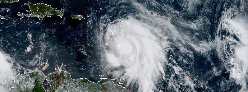
Featured image: Hurricane "Maria" at 15:00 UTC on September 18, 2017. Credit: NOAA/GOES-16 (preliminary and non-operational)
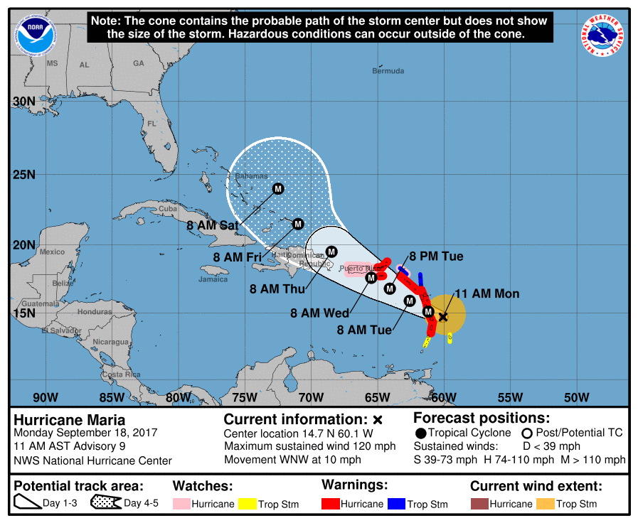
Hurricane "Maria" is expected to rapidly intensify over the next 48 hours and slam into the Leeward Islands as a major, Category 3 or 4 hurricane late Monday, September 18 / early Tuesday, September 19, 2017 (local time). Maria is then expected to move over the extreme northeastern Caribbean Sea on September 19 and approach Puerto Rico and the Virgin Islands on Wednesday, September 20.
At 15:00 UTC on September 18, the center of Hurricane "Maria" was located 95 km (60 miles) E of Martinique and 150 km (95 miles) ESE of Dominica. The system is moving WNW at 17 km/h (10 mph) with maximum sustained winds of 195 km/h (120 mph), making it a Category 3 hurricane on the Saffir-Simpson Hurricane Wind Scale. Maria's estimated minimum central pressure is 959 hPa.
Additional rapid strengthening is forecast during the next 48 hours, and Maria is expected to be a dangerous major hurricane as it moves through the Leeward Islands and the northeastern Caribbean Sea.
On the forecast track, the center of Maria will move across the Leeward Islands late today, September 18 and tonight, over the extreme northeastern Caribbean Sea Tuesday, September 19 and Tuesday night, and approach Puerto Rico and the Virgin Islands on Wednesday, September 20.
A Hurricane Warning is in effect for:
- Guadeloupe
- Dominica
- St. Kitts, Nevis, and Montserrat
- Martinique
- St. Lucia
- U.S. Virgin Islands
- British Virgin Islands
A Hurricane Warning means that hurricane conditions are expected somewhere within the warning area. Preparations to protect life and property should be rushed to completion.
A Tropical Storm Warning is in effect for:
- Antigua and Barbuda
- Saba and St. Eustatius
- St. Maarten
- Anguilla
A Tropical Storm Warning means that tropical storm conditions are expected somewhere within the warning area.
A Hurricane Watch is in effect for:
- Puerto Rico, Vieques, and Culebra
- Saba and St. Eustatius
- St. Maarten
- St. Martin and St. Barthelemy
- Anguilla
A Hurricane Watch means that hurricane conditions are possible within the watch area. A watch is typically issued 48 hours before the anticipated first occurrence of tropical-storm-force winds, conditions that make outside preparations difficult or dangerous.
A Tropical Storm Watch is in effect for:
- Barbados
- St. Vincent and the Grenadines
A Tropical Storm Watch means that tropical storm conditions are possible within the watch area, generally within 48 hours.
Interests elsewhere in the Lesser Antilles and the Dominican Republic should monitor the progress of this system. Hurricane Warnings will likely be issued for Puerto Rico and the nearby islands this afternoon.
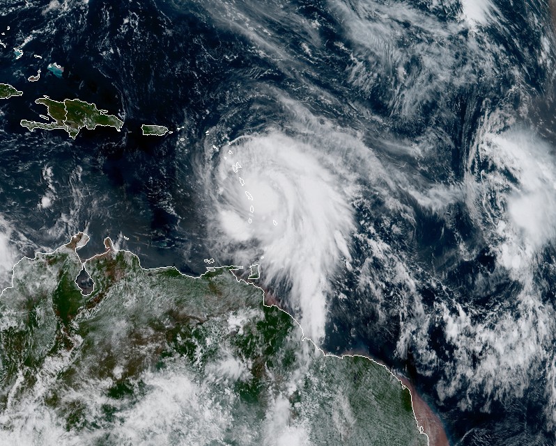
Hurricane "Maria" at 15:00 UTC on September 18, 2017. Credit: NOAA/GOES-16 (preliminary and non-operational)
Hurricane conditions are first expected within portions of the Leeward Islands by late today (local time), with tropical storm conditions beginning during the next few hours. Hurricane conditions should spread through the remainder of the hurricane warning area tonight through Tuesday night. Hurricane conditions are possible within the hurricane watch area Tuesday through Wednesday, with tropical storm conditions possible later today or tonight. Tropical storm conditions are possible in the tropical storm watch area through tonight.
A dangerous storm surge accompanied by large and destructive waves will raise water levels by as much as 1.8 to 2.7 m (6 to 9 feet) above normal tide levels in the hurricane warning area near where the center of Maria moves across the Leeward Islands and the British Virgin Islands.
The combination of a dangerous storm surge and the tide will cause normally dry areas near the coast to be flooded by rising waters moving inland from the shoreline. The water is expected to reach the following heights above ground if the peak surge occurs at the time of high tide:
Puerto Rico and the U.S. Virgin Islands: 1.8 to 2.7 m (6 to 9 feet)
The deepest water will occur along the immediate coast near and to the north and east of the landfall location, where the surge will be accompanied by large and destructive waves. Surge-related flooding depends on the relative timing of the surge and the tidal cycle, and can vary greatly over short distances.
Maria is expected to produce total rain accumulations of 152 to 304 mm (6 to 12 inches) with isolated maximum amounts of 508 mm (20 inches) across the central and southern Leeward Islands, and the U.S. and British Virgin Islands through Wednesday night. Rainfall amounts of 152 to 304 mm (6 to 12 inches) with isolated maximum amounts of 635 mm (25 inches) are expected across Puerto Rico.
Maria is also expected to produce total rain accumulations of 51 to 102 mm (2 to 4 inches) with isolated maximum amounts of 203 mm (8 inches) over the remaining northern Leeward Islands from Barbuda to Anguilla, eastern portions of the Dominican Republic, as well as the Windward Islands and Barbados. Rainfall on all of these islands could cause life-threatening flash floods and mudslides.
Swells generated by Maria are affecting the Lesser Antilles. These swells are likely to cause life-threatening surf and rip current conditions.
I'm a dedicated researcher, journalist, and editor at The Watchers. With over 20 years of experience in the media industry, I specialize in hard science news, focusing on extreme weather, seismic and volcanic activity, space weather, and astronomy, including near-Earth objects and planetary defense strategies. You can reach me at teo /at/ watchers.news.
Commenting rules and guidelines
We value the thoughts and opinions of our readers and welcome healthy discussions on our website. In order to maintain a respectful and positive community, we ask that all commenters follow these rules.