
Tropical Storm “Fiona” expected to become a hurricane while moving near Puerto Rico
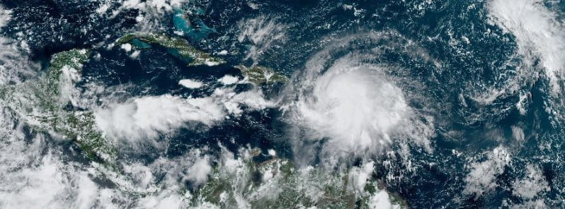
Featured image: Tropical Storm "Fiona" at 18:50 UTC on September 17, 2022. Credit: NOAA/GOES-East, The Watchers
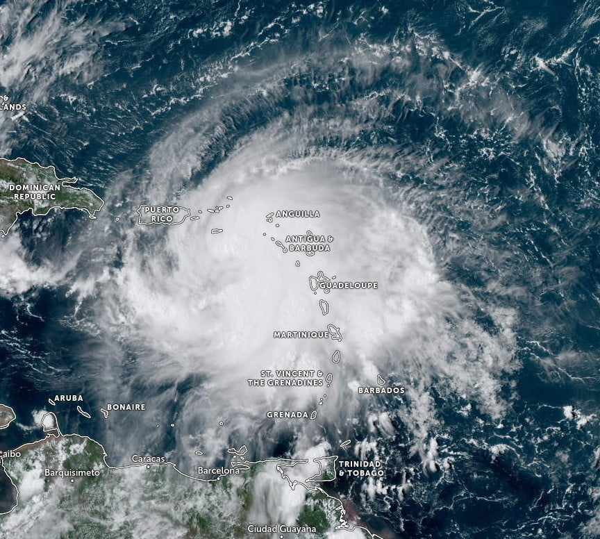
Heavy rains produced by Tropical Storm “Fiona” continue over portions of the Leeward Islands and are spreading across the Virgin Islands. The storm is strengthening and moving toward Puerto Rico and the Dominican Republic.
- Hurricane conditions are expected across portions of Puerto Rico Sunday and Sunday night, September 18, and are possible across the U.S. Virgin Islands tonight and Sunday.
- Tropical storm conditions will continue to affect portions of the Leeward Islands today and will spread westward to the U.S. and British Virgin Islands later today, and to Puerto Rico tonight.
- Tropical storm conditions will reach the Dominican Republic by Sunday night.
- Heavy rains from Fiona will spread west to the British and U.S. Virgin Islands and Puerto Rico today, the Dominican Republic Sunday, and the Turks and Caicos Monday night. This rainfall is likely to produce considerable flood impacts including flash and urban flooding, along with mudslides in areas of higher terrain, particularly in Puerto Rico.
- Fiona is forecast to strengthen while moving near Puerto Rico and the Dominican Republic through Monday, and interests in the Turks and Caicos Islands and southeastern Bahamas should continue to monitor forecasts for the storm.
At 18:00 UTC on September 17, the center of Tropical Storm “Fiona” was located about 145 km (90 miles) NNW of St. Croix. It had maximum sustained winds of 95 km/h (60 mph), minimum central pressure of 1 002 hPa, and was moving W at 13 km/h (8 mph).1
A west-northwestward motion at a similar forward speed is expected to begin later today, followed by a turn toward the northwest by Sunday evening.
On the forecast track, the center of Fiona is expected to move near or south of the Virgin Islands this evening, approach Puerto Rico tonight, and move near or over Puerto Rico Sunday night.
Fiona should then move near the Dominican Republic on Monday.
Strengthening is forecast during the next few days, and Fiona is expected to become a hurricane by Sunday or Sunday night while moving near Puerto Rico.
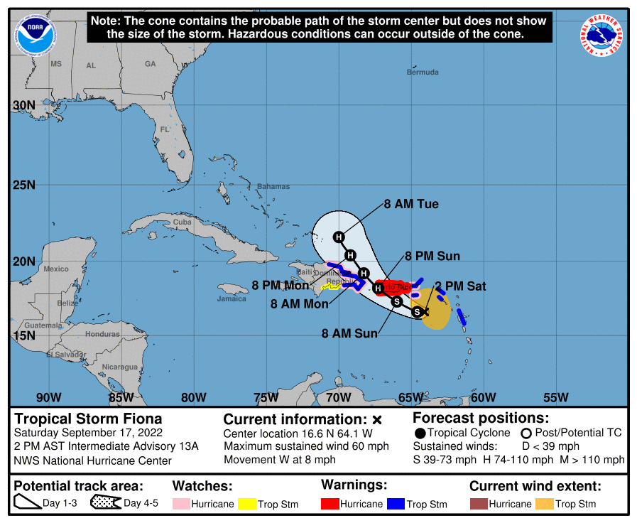
A Hurricane Watch is in effect for the U.S. Virgin Islands; South coast of the Dominican Republic from Cabo Engano westward to Cabo Caucedo; North coast of the Dominican Republic from Cabo Engano westward to Puerto Plata.
A Tropical Storm Warning is in effect for Saba and St. Eustatius; St. Maarten; Guadeloupe, St. Barthelemy, and St. Martin; U.S. Virgin Islands; British Virgin Islands; South coast of the Dominican Republic from Cabo Engano westward to Cabo Caucedo; North coast of the Dominican Republic from Cabo Engano westward to Puerto Plata.
A Tropical Storm Watch is in effect for the areas South coast of the Dominican Republic west of Cabo Caucedo to Barahona
Very heavy rains and flooding have occurred over portions of the Leeward Islands since Friday, September 16.
A station at St. Claude Matouba Irfa, in the mountains in southwestern Guadeloupe, recently measured a 24-hour rainfall total of 494.3 mm (19.46 inches).
Fiona is forecast to produce the following rainfall:
- Leeward Islands and Northern Windward Islands: Additional 50 – 100 mm (2 to 4 inches).
- British and U.S. Virgin Islands: 100 – 150 mm (4 to 6 inches) with local maximum of 250 mm (10 inches) possible.
- Puerto Rico: 300 – 400 mm (12 to 16 inches) with local maximum of 500 mm (20 inches) possible, particularly across eastern and southern Puerto Rico.
- Dominican Republic: 100 – 200 mm (4 to 8 inches) with local maximum of 300 mm (12 inches) possible, particularly on the far eastern coast.
- Haiti: 50 to 75 mm (1 to 3 inches) with isolated maximum totals of 100 mm (4 inches).
- Turks and Caicos: 100 to 150 mm (4 to 6 inches).
These rains are likely to produce flash and urban flooding, along with mudslides in areas of higher terrain, particularly southern and eastern Puerto Rico and the eastern Dominican Republic.
The combination of storm surge and the tide will cause normally dry areas near the coast to be flooded by rising waters moving inland from the shoreline.
The water could reach the following heights above ground somewhere in the indicated areas in areas of onshore winds if the peak surge occurs at the time of high tide:
- Southern coast of Puerto Rico: 30 – 90 cm (1 to 3 feet)
- Vieques and Culebra: 30 – 90 cm (1 to 3 feet)
- U.S. Virgin Islands: 30 – 60 cm (1 to 2 feet)
Storm surge will raise water levels by as much as 30 – 90 cm (1 to 3 feet) above normal tide levels along the immediate coast in areas of onshore winds in the Dominican Republic.
Swells generated by Fiona are affecting the Leeward Islands, the northern Windward Islands, the Virgin Islands, Puerto Rico, the northern coast of the Dominican Republic, the Turks and Caicos Islands, and the southeastern Bahamas.
These conditions could cause life-threatening surf and rip current conditions.
References:
1 Tropical Storm Fiona Intermediate Advisory Number 13A – NWS National Hurricane Center Miami FL – 200 PM AST Sat Sep 17 2022
I'm a dedicated researcher, journalist, and editor at The Watchers. With over 20 years of experience in the media industry, I specialize in hard science news, focusing on extreme weather, seismic and volcanic activity, space weather, and astronomy, including near-Earth objects and planetary defense strategies. You can reach me at teo /at/ watchers.news.
Commenting rules and guidelines
We value the thoughts and opinions of our readers and welcome healthy discussions on our website. In order to maintain a respectful and positive community, we ask that all commenters follow these rules.