
Historically powerful Alaska storm, U.S.
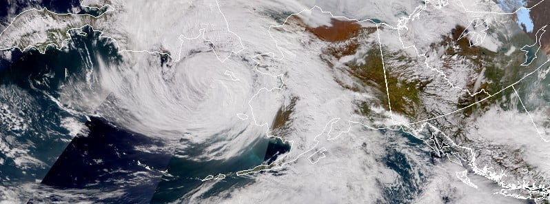
Image credit: NASA/NOAA JPSS
Remnants of Typhoon “Merbok” will bring potentially historical coastal flooding, high surf, coastal erosion, high winds, high seas and heavy rain to western Alaska and the Bering Sea through the weekend, the National Weather Service (NWS) warns.
- Residents of the affected region are urged to take the necessary actions to protect flood-prone property. If travel is required, do not drive around barricades or through water of unknown depth.
Significant coastal flooding is expected across western Alaska over the weekend as remnants of Typhoon “Merbok” enter the region, bringing disruptive rainfall and very strong winds.
Numerous Coastal Flood Warnings are in effect. Areas affected include Southern Seward Peninsula Coast, Eastern Norton Sound and Nulato Hills, St Lawrence Island and Bering Strait Coast, Yukon Delta, Chukchi Sea Coast, Baldwin Peninsula and Selawik Valley, Northern and Interior Seward Peninsula, as of 03:59 AKDT on September 17 (11:59 UTC).
Numerous roads may be closed as a result across Southern Seward Peninsula Coast. Low lying property including homes, businesses, the airport, and other critical infrastructure will be inundated while some shoreline erosion will occur.
In Nome, water levels will be 2.4 to 3.3 m (8 to 11 feet) above the normal high tide line. Areas near the mouth of the Snake River and upstream, will also be inundated as water backs up in the river due to the storm surge. The Belmont Subdivision will be significantly impacted by flooding, as will the Airport Terminal, and some areas of the runway may be flooded.
Streets on the west side of town may also be flooded.
The Nome/Council Road may be impassable as waves run well up the beach.
In Golovin, water levels will be 2.7 m to 3.9 m (9 to 13 feet) above the normal high tide line. Golovin will see significant inundation around the old runway and water may flood around the fuel storage area and areas lower than the school. Highest water levels are expected Saturday morning through Saturday evening, September 17.
Significant flooding is also expected in Eastern Norton Sound and Nulato Hills.
From Shaktoolik to Stebbins, water levels will be 2.4 to 3.6 m (8 to 12 feet) above the normal high tide line. The Shaktoolik Airport will also be impacted.
The high water may surround some building in Shaktoolik.
In Unalakleet, water will inundate areas around the AC Store and Lodge.
Flooding will also occur in the north end of town and in low lying areas around the runway.
Roads and houses near the coast at Stebbins and St Michael will be flooded.
In Elim and Koyuk, water levels will be 3.6 to 5.4 m (12 to 18 feet) above the normal high tide line. At Elim, the water and sewer system may back up as high water and persistent southeast winds push water up the creek and may contaminate the water supply.
At Koyuk, water will back up in the Koyuk River and Creek with flooding around the store warehouse and other low lying areas. Highest water levels are expected Saturday afternoon through Sunday morning.
Water levels will be 0.9 to 2.4 m (3 to 8 feet) above the normal high tide line in St Lawrence Island and Bering Strait Coast. Expect water to fill the lagoon at Brevig Mission which may surround some buildings, and may flood Port Clarence Road.
In Teller, portions of Front Ave may be flooded. Tin City post office may flood and water may surround the fuel storage tanks. In Gambell, high water may impact the dump. Significant erosion is possible at Little Diomede. Highest water levels are expected Saturday into Saturday night.
Water levels will also be 0.9 to 2.4 m (3 to 8 feet) above the normal high tide line across the Yukon Delta.
Most if not all of Nunam Iqua will be impacted by flooding, NWS Fairbanks warns.
Water will back up in the river at Kotlik and flooding will occur around houses and in low lying areas. Scammon Bay will be impacted as water in the Kun River backs up and floods the west end of the runway and adjacent low lying areas.
Hooper Bay fuel storage area will be inundated and the road to the airport will be partially submerged. Flooding is possible upstream on the Yukon River to Mountain Village with significant flooding at Emmonak and Alakanuk. Highest water levels are expected Friday night through Saturday.
Chukchi Sea coast is also on Coastal Flood Warning. Water levels are expected to rise 1.5 to 2.1 m (5 to 7 feet) above the normal high tide level. The highest water levels are expected Sunday.
Buildings in Kivalina on the lagoon side of town are at risk for flooding.
In Shishmaref, the airstrip will likely be impacted. Wave run-up from the coast may impact buildings near the sewage lagoon.
Water levels are expected to rise 1.2 to 1.8 m (4 to 6 feet) above the normal high tide level in Baldwin Peninsula and Selawik Valley. Highest water levels are expected Saturday night into Sunday. Teacher housing in Kotzebue will potentially be impacted.
Northern and Interior Seward Peninsula can expect water levels to be 0.9 to 1.5 m (3 to 5 feet) above the normal high tide level. Roads and houses near the coast at Deering may be inundated.
In Buckland, low lying areas around houses may flood. Highest water levels are expected Saturday night into Sunday.
NWS is urging residents of the affected regions to take the necessary actions to protect flood-prone property. If travel is required, do not drive around barricades or through water of unknown depth.
High Wind Warnings and Wind Advisories are in effect across the region.
I'm a dedicated researcher, journalist, and editor at The Watchers. With over 20 years of experience in the media industry, I specialize in hard science news, focusing on extreme weather, seismic and volcanic activity, space weather, and astronomy, including near-Earth objects and planetary defense strategies. You can reach me at teo /at/ watchers.news.
Commenting rules and guidelines
We value the thoughts and opinions of our readers and welcome healthy discussions on our website. In order to maintain a respectful and positive community, we ask that all commenters follow these rules.