
Tropical Cyclone 16P (Cook) wreaking havoc on Vanuatu, heading toward New Caledonia
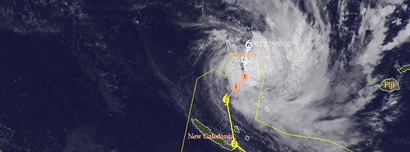
Featured image: Tropical Cyclone 16P (Cook) on April 8, 2017. Credit: UW-CIMSS
Tropical Cyclone 16P, soon to be named Cook, is wreaking havoc on Vanuatu today, April 8, 2017. The cyclone is expected to intensify over the coming days on its way to New Caledonia. It comes at the end of the official cyclone season, which runs from November to April.
At 03:00 UTC on April 8, 2017, Tropical Cyclone 16P was located approximately 816 km (507 miles) NNW of Noumea, New Caledonia and has tracked west-southwestward at 7 km/h (4.6 mph) over the past six hours, JTWC said. Animated multispectral imagery shows deep convective banding wrapping into a consolidating low level circulation.
At 00:00 UTC today, 16P had maximum sustained winds of 64.8 km/h (40 mph) and gusts to 83 km/h (51.7 mph).
TS #16P, west of #Fiji, is wreaking havoc on #Vanuatu & expected to intensify into a Category 2 Cyclone (#Cook) en route to #NewCaledonia. pic.twitter.com/e0hFlkVWfg
— UW-Madison CIMSS (@UWCIMSS) April 8, 2017
Poss tracks (black is ensemble mean) soon-to-be #TCCook as it nears NZ – note shift west – offical advice @FijiMet https://t.co/WhMFlK9yhT pic.twitter.com/xBR0xtDanu
— NIWA Weather (@NiwaWeather) April 8, 2017
Upper level analysis indicated the system is currently in an area of low to moderate vertical wind shear and excellent poleward and equatorward outflow. The system is tracking through an area of high sea surface temperatures (29 – 30 °C / 84.2 – 86 °F) under the steering influence of two ridges, one to the east and one to the west. These two ridges will steer the storm generally to the south and will remain the primary steering feature over the next couple of days.
Favorable environmental conditions are expected to persist for the next 48 – 72 hours resulting in likely near-term rapid intensification followed by steady intensification to a peak of 167 km/h (103 mph). This would make Cook a major, Category 3 system on the Saffir-Simpson Hurricane Wind Scale. The system is expected to begin extratropical transition in about 96 hours (4 days) and complete it by about 03:00 UTC on April 13.
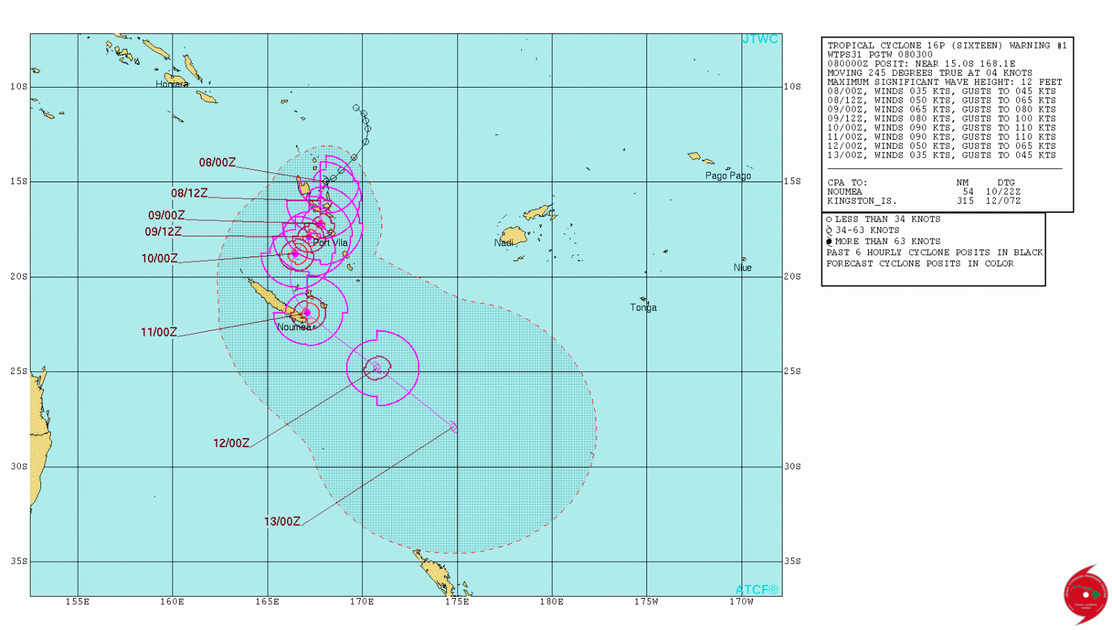
Tropical Cyclone 16P (Cook) JTWC forecast track on April 8, 2017
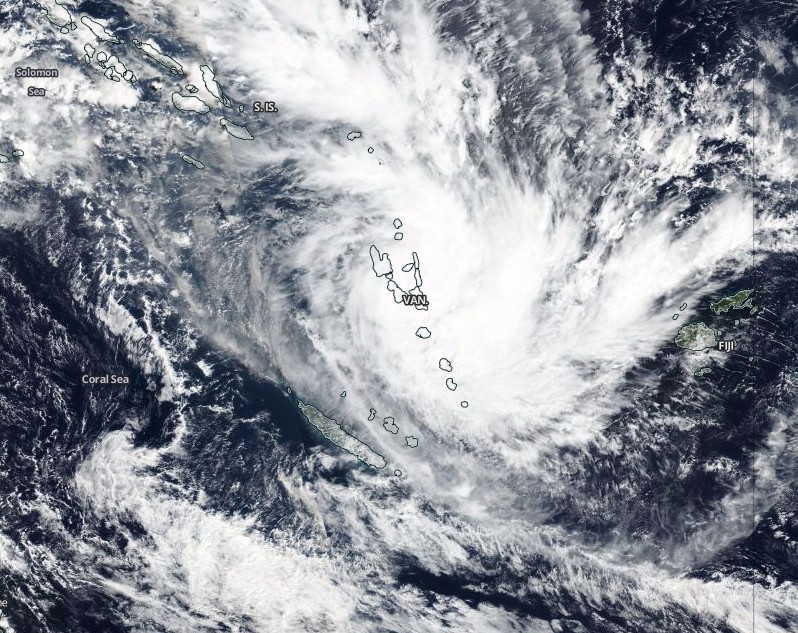
Tropical Cyclone 16P (Cook) on April 8, 2017. Credit: NASA/NOAA/DoD Suomi NPP/VIIRS
At 09:00 UTC (20:00 Vanuatu time), the system was located about 60 km (37 miles) south-southwest of Malekula and 120 km (74 miles) northwest of Efate. It was moving south at a speed of 21 km/h (13 mph), the Vanuatu Meteorology nad Geo-Hazards Department in Port Vila said.
The central pressure of the system was estimated at 997 hPa. Winds close to the center were estimated at 55 km/h (34 mph), increasing to 75 km/h (46.6 mph) within the next 6 to 12 hours. The potential for the system to become a tropical cyclone within the next 12 hours is high.
Damaging gale force winds of 75 km/h (46.6 mph) and very rough seas with heavy swells are expected to affect the Malampa, Penama, Sanma and Shefa provinces.
Heavy rainfall and flooding are expected over low lying areas and areas close to river banks. Coastal flooding is also expected, the department said.
According to current forecast tracks, 16P will reach category 1 shortly after it moves away from Vanuatu.
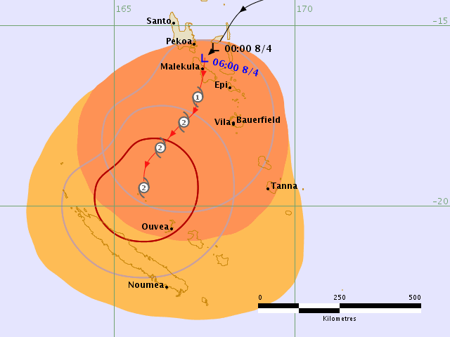
Tropical Cyclone 16P (Cook) hazard map. Credit: RSMC NADI
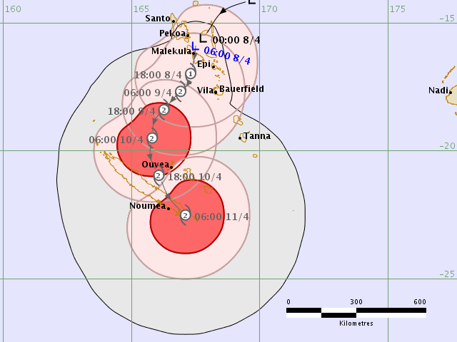
Tropical Cyclone 16P (Cook) forecast track on April 8, 2017. Credit: RSMC NADI
I'm a dedicated researcher, journalist, and editor at The Watchers. With over 20 years of experience in the media industry, I specialize in hard science news, focusing on extreme weather, seismic and volcanic activity, space weather, and astronomy, including near-Earth objects and planetary defense strategies. You can reach me at teo /at/ watchers.news.
Hi!, just wanted to say that, compared to other TC in the region of the south Pacific Cyclone Pam is one of the most dangerous and monstrous TC have ever seen in my life. And also, it will be a unforgettable memory and a better history for kids who wish to study Geography and Learn more about what it really means when comes to Natural hazard issues. Just wanted to add on by saying that it is so true that Natural disaster is beyond human control.. thank you..
True, thank you for sharing your experience with us.