
Powerful nor’easter to hit the East Coast
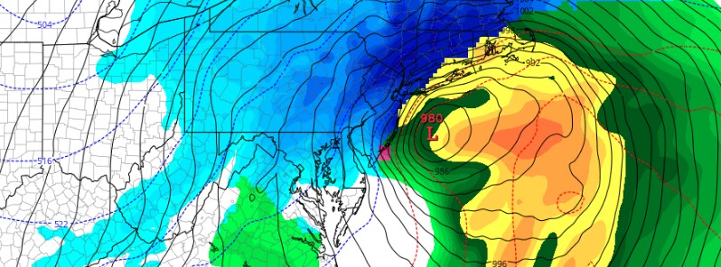
Featured image: Powerful nor'easter to hit the East Coast - March 14, 2017. Credit: GFS/TropicalTidbits
A major, late-season winter storm is about to hit the US East Coast on Tuesday, March 14, 2017, bringing very heavy snow, ice, strong winds and dangerous travel conditions from the Middle Atlantic to New England. Some regions can expect up to 61 cm (2 feet) of snow. Strong winds could down trees and cause power outages.
The National Weather Service warns that the heaviest snowfall is expected to occur from the northern Middle Atlantic to Southern New England where 30 to 46 cm (12 to 18 inches) can be expected with localized amounts up to 61 cm (2 feet).
"It continues feeling like winter across much of the country, despite it is now mid-March," NWS meteorologist David Hamrick said.
"A large surface high pressure ridge over south-central Canada is sprawling southward into the central and eastern U.S., allowing for a continuous supply of January-like temperatures through the middle of the work week. Afternoon highs are expected to be on the order of 15 to 30 degrees below normal from the northern Plains to the Mid-Atlantic region, with the possibility of some record lows," he said.
Things get interesting for the East Coast beginning Monday night.
A low pressure system crossing the Midwest states and Ohio Valley is expected to phase with another low off the southeast US coast. This will allow for a strong nor'easter to develop near the coast and cause a late-season snowstorm from the central Appalachians to New England, including many of the big cities in the Northeast US.
Widespread winter storm warnings are now in effect for heavy snowfall accumulations, with some areas likely getting in excess of a foot from eastern Pennsylvania to southern New England.
The tricky part of the forecast deals with the rain/snow line over the Mid-Atlantic region with a tight gradient in accumulations expected near the greater Washington DC metro area. Closer to the coast from southern New Jersey to the Carolinas, rain is expected with amounts in excess of 25.4 mm (1 inch) likely.
"A powerful Nor’easter developing tonight in the Mid-Atlantic promises to deliver every type of winter precipitation imaginable across the metro region," said Jason Samenow, the Washington Post’s weather editor and Capital Weather Gang's chief meteorologist.
"Heavy snow is likely to plaster our far north and west areas. A mix of accumulating snow, sleet and rain will hit the District and close-in suburbs, while our southern and eastern areas see more cold rain with some sleet and snow mixed in.
Precipitation will move into the region between about 18:00 and 21:00 but should not cause problems for the evening commute, given temperatures above freezing. Overnight, conditions will vary considerably over short distances.
"You may only have to travel 10 miles [16 km] to go from 5 to 10 inches [13 and 25 cm] of snow to very little. Tuesday morning’s commute is likely to be a mess, with heavy snow in our colder areas and a sloppy mix in the immediate metro," Samenow said.
This storm has been named by The Weather Channel as Winter Storm Stella.
I'm a dedicated researcher, journalist, and editor at The Watchers. With over 20 years of experience in the media industry, I specialize in hard science news, focusing on extreme weather, seismic and volcanic activity, space weather, and astronomy, including near-Earth objects and planetary defense strategies. You can reach me at teo /at/ watchers.news.
Commenting rules and guidelines
We value the thoughts and opinions of our readers and welcome healthy discussions on our website. In order to maintain a respectful and positive community, we ask that all commenters follow these rules.