
Four dead after shallow M5.3 earthquake hits southern Iran
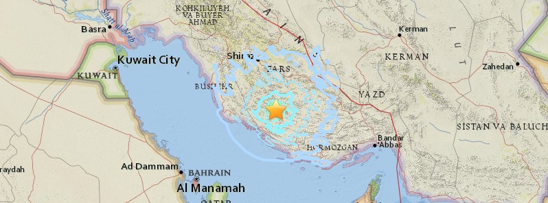
Image credit: USGS
Four people have been killed and another 4 injured after a shallow earthquake registered by the USGS as M5.3 hit southern Iran at 02:33 UTC (06:03 local time) on January 6, 2017. The quake hit at a depth of 10 km (6.2 miles). EMSC is reporting M5.2 at the same depth. Iran is one of the most seismically active countries in the world and this quake has, once again, raised fears of a 'big one.' Experts warn building codes are almost universally ignored in Iran. Capital Tehran is especially vulnerable to earthquakes.
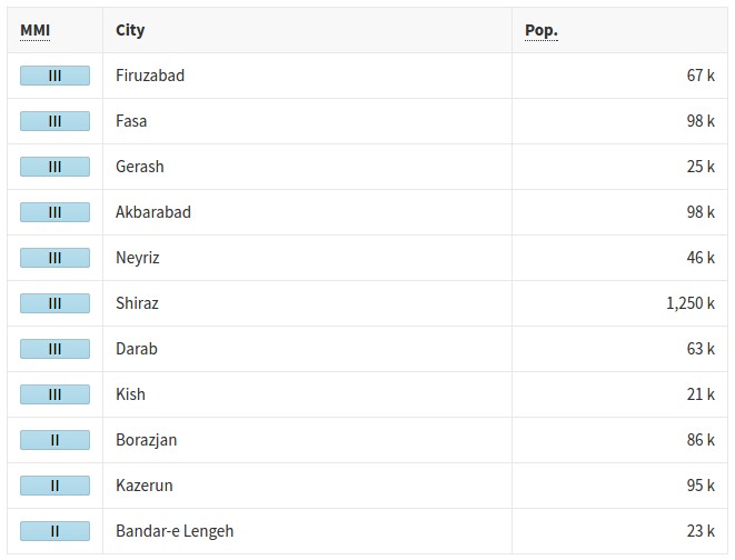
According to the USGS, the epicenter was located 31.8 km (19.7 miles) SSE of Qīr (population 0), 88.7 km (55.1 miles) SE of Fīrūzābād (population 66 558), and 96.5 km (60.0 miles) SSW of Fasā (population 98 061), Iran.
As a result of the earthquake, the walls of old buildings crumbled and the local power grid was shut down, the PressTV reported.
According to the director general of the province’s crisis management organization, Hasan Fayyazpour, the entire area is currently on a state of alert. Fayyazpour noted that those killed were Afghan nationals.
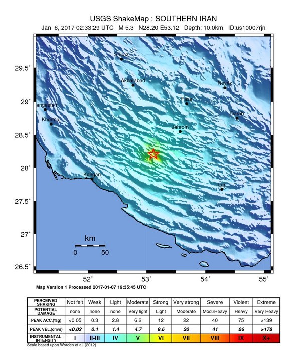
USGS issued a yellow alert level for shaking-related fatalities. Some casualties are possible and the impact should be relatively localized. Past events with this alert level have required a local or regional level response. Green alert level was issued for economic losses. There is a low likelihood of damage.
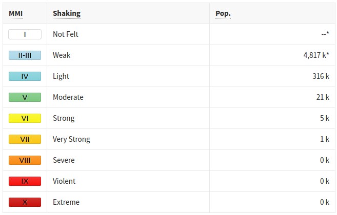
Overall, the population in this region resides in structures that are highly vulnerable to earthquake shaking, though some resistant structures exist.
Recent earthquakes in this area have caused secondary hazards such as landslides that might have contributed to losses.
Estimated population exposure to earthquake shaking
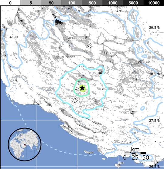
Selected cities exposed
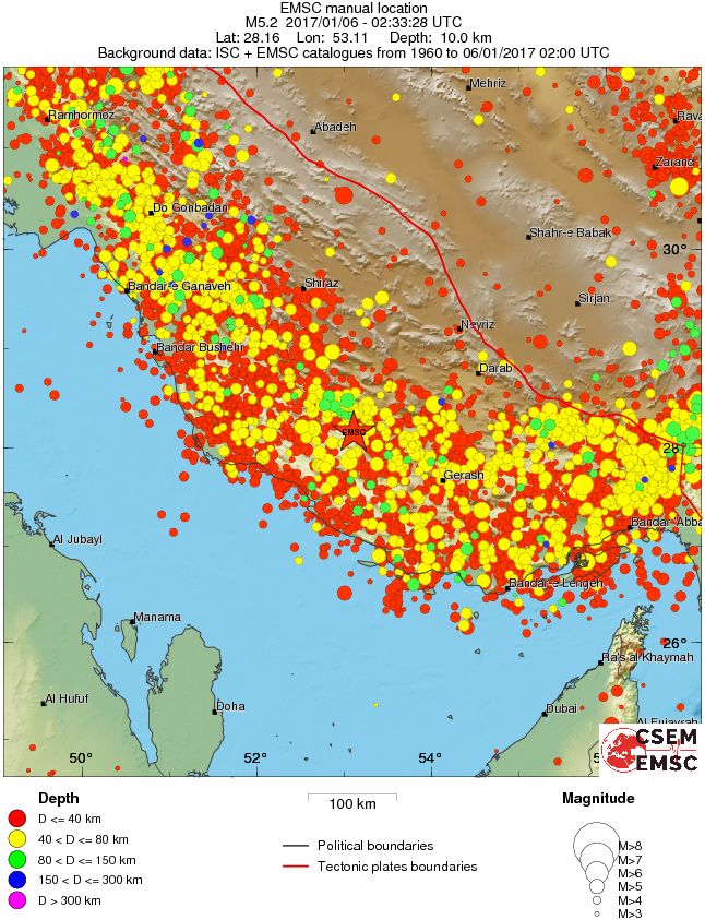
Regional seismicity
Fears of a 'big one'
Iran is one of the most seismically active countries in the world, being crossed by several major faults that cover at least 90% of the country. As a result, earthquakes in Iran occur often and are destructive.
The country has suffered several devastating earthquakes in recent years. Most notably, a M6.6 on December 22, 2003 which flattened the southeastern city of Bam, killing between 26 271 and 43 200 people. More than 30 000 were injured.
Since 1900, at least 126 000 fatalities have resulted from earthquakes in Iran.
Experts have previously warned that hundreds of thousands of people could die if a powerful earthquake one day struck Tehran. They say building codes are almost universally ignored
Bahram Akasheh, considered one of Iran's leading experts on earthquakes and seismic activity, has repeatedly warned that Tehran is especially vulnerable to earthquakes.
He has been one of the foremost proponents for moving the Iranian capital of Tehran to Isfahan because of a distinct threat from a devastating earthquake.
According to Akasheh's calculations, there is a 90 percent chance of a 6.0-magnitude quake hitting the capital and a 50 percent chance of 7.5-magnitude earthquake, The Guardian wrote in 2004.
The vast majority of buildings in Tehran are located on the convergence of some 100 known fault lines which in its present architectural form are incapable of withstanding even a moderate earthquake.
A hypothesis presented by Akasheh indicates that a 6.8 quake in Tehran would kill at least 725 000 people.
According to Akasheh, "Tehran must be rebuilt; if not it should be moved. Either we have to put up with millions of dead, millions of injured, or we need to move the capital somewhere else and take steps to decrease the population here and make Tehran more resistant to earthquakes."
Seismotectonics of the Middle East and vicinity
No fewer than four major tectonic plates (Arabia, Eurasia, India, and Africa) and one smaller tectonic block (Anatolia) are responsible for seismicity and tectonics in the Middle East and surrounding region. Geologic development of the region is a consequence of a number of first-order plate tectonic processes that include subduction, large-scale transform faulting, compressional mountain building and crustal extension.
Mountain building in northern Pakistan and Afghanistan is the result of compressional tectonics associated with collision of the India plate moving northwards at a rate of 40 mm/yr with respect to the Eurasia plate. Continental thickening of the northern and western edge of the India subcontinent has produced the highest mountains in the world, including the Himalayan, Karakoram, Pamir and Hindu Kush ranges. Earthquake activity and faulting found in this region, as well as adjacent parts of Afghanistan and India, are due to collisional plate tectonics.
Beneath the Pamir-Hindu Kush Mountains of northern Afghanistan, earthquakes occur to depths as great as 200 km as a result of remnant lithospheric subduction. Shallower crustal earthquakes in the Pamir-Hindu Mountains occur primarily along the Main Pamir Thrust and other active Quaternary faults, which accommodate much of the region's crustal shortening. The western and eastern margins of the Main Pamir Thrust display a combination of thrust and strike-slip mechanisms.
Along the western margin of the Tibetan Plateau, in the vicinity of southeastern Afghanistan and western Pakistan, the India plate translates obliquely relative to the Eurasia plate, resulting in a complex fold-and-thrust belt known as the Sulaiman Range. Faulting in this region includes strike-slip, reverse-slip and oblique-slip motion and often results in shallow, destructive earthquakes. The relatively fast moving left-lateral, strike-slip Chaman Fault system in southeastern Afghanistan accommodates translational motion between the India and Eurasia plates. In 1505, a segment of the Chaman Fault system near Kabul, Afghanistan ruptured causing widespread destruction of Kabul and surrounding villages. In the same region, the more recent 30 May 1935, M7.6 Quetta, Pakistan earthquake, occurred within the Sulaiman Range, killing between 30,000 and 60,000 people.
Off the south coast of Pakistan and southeast coast of Iran, the Makran trench is the present-day surface expression of active subduction of the Arabia plate beneath the continental Eurasia plate, which converge at a rate of approximately 20 mm/yr. Although the Makran subduction zone has a relatively slow convergence rate, it has produced large devastating earthquakes and tsunamis. For example, the November 27, 1945 M8.0 mega-thrust earthquake produced a tsunami within the Gulf of Oman and Arabia Sea, killing over 4,000 people. Northwest of this active subduction zone, collision of the Arabia and Eurasia plates forms the approximately 1,500-km-long fold and thrust belt of the Zagros Mountains, which crosses the whole of western Iran and extends into northeastern Iraq. Collision of the Arabia and Eurasia plates also causes crustal shortening in the Alborz Mountains and Kopet Dag in northern Iran. Eastern Iran experiences destructive earthquakes that originate on both strike-slip and reverse faults. For example, the 16 September 1978 M7.8 earthquake, along the southwest edge of the Dasht-e-Lut Basin killed at least 15,000 people.
Along the eastern margin of the Mediterranean region there is complex interaction between the Africa, Arabia and Eurasia plates. The Red Sea Rift is a spreading center between the Africa and Arabia plates, with a spreading rate of approximately 10mm/yr near its northern end, and 16mm/yr near its southern end (Chu, D. and Gordon, R. G., 1998). Seismicity rate and size of earthquakes has been relatively small along the spreading center, but the rifting process has produced a series of volcanic systems across western Saudi Arabia.
Further north, the Red Sea Rift terminates at the southern boundary of the Dead Sea Transform Fault. The Dead Sea Transform is a strike-slip fault that accommodates differential motion between the Africa and Arabia plates. Though both the Africa plate, to the west, and the Arabia plate, to the east, are moving in a NNE direction, the Arabia plate is moving slightly faster, resulting in the left-lateral, strike-slip motion along this segment of the plate boundary. Historically, earthquake activity along the Dead Sea Transform has been a significant hazard in the densely populated Levant region (eastern Mediterranean). For example, the November 1759 Near East earthquake is thought to have killed somewhere between 2,000-20,000 people. The northern termination of the Dead Sea Transform occurs within a complex tectonic region of southeast Turkey, where interaction of the Africa and Arabia plates and the Anatolia block occurs. This involves translational motion of the Anatolia Block westwards, with a speed of approximately 25mm/yr with respect to Eurasia, in order to accommodate closure of the Mediterranean basin.
The right-lateral, strike-slip North Anatolia Fault, in northern Turkey, accommodates much of the westwards motion between the Anatolia Block and Eurasia Plate. Between 1939 and 1999, a series of devastating M7.0+ strike-slip earthquakes propagated westwards along the North Anatolia Fault system. The westernmost of these earthquakes was the 17th August 1999, M7.6 Izmit earthquake, near the Sea of Marmara, killed approximately 17,000 people.
At the southern edge of the Anatolia Block lies the east-west trending Cyprian Arc with associated levels of moderate seismicity. The Cyprian Arc represents the convergent boundary between the Anatolia Block to the north and the Africa Plate to the south. The boundary is thought to join the East Anatolia Fault zone in eastern Turkey; however no certain geometry or sense of relative motion along the entire boundary is widely accepted. (USGS)
The Watchers team and our contributors bring the latest on extreme weather, earthquakes, volcanic eruptions, space weather, and all things science. We're all about making sense of the natural world and keeping you informed on what’s happening. Got a tip or a question? Hit us up using the form at newstips!
Commenting rules and guidelines
We value the thoughts and opinions of our readers and welcome healthy discussions on our website. In order to maintain a respectful and positive community, we ask that all commenters follow these rules.