
Strong and shallow M6.5 earthquake hits central Italy, the strongest since 1980
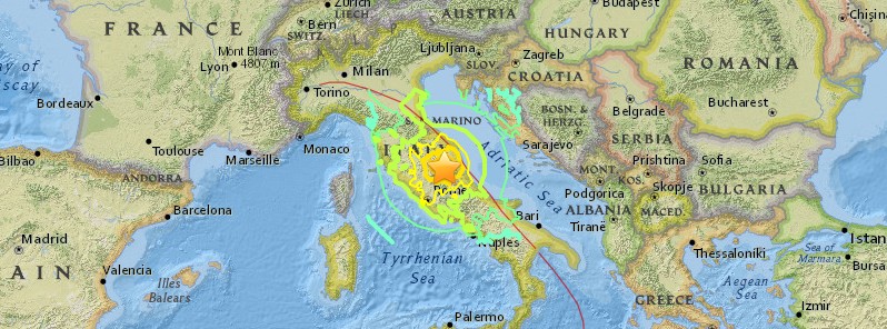
Image credit: USGS
A strong and shallow earthquake registered by the EMSC as M6.5 hit central Italy at 06:40 UTC on October 30, 2016. The agency is reporting a depth of 10 km (6.2 miles). USGS is reporting M6.6 at a depth of 10 km.
According to the EMSC, the epicenter was located 16 km (9.9 miles) N of Maltignano (population 2 600), 38 km (23.6 miles) W of Ascoli Piceno (population 51 400), 59 km (36.6 miles) NW of L’Aquila (population 68 600) and 117 km (72.7 miles) NE of Roma (population 2 564 000), Italy.
There are 2 744 538 people living within 100 km (62 miles). Some 30 million people are estimated to be living in the felt area.
The quake comes just 4 days after M6.1 hit the same region and two months after deadly M6.2 of August 24, 2016.
EMSC said this is the strongest earthquake in Italy since 1980, and an unprecedented sequence of 3 large shocks in 4 days for the country – M5.5, M6.1 and M6.5 – the strongest ground motion ever recorded.
There were no immediate reports of casualties, but tremors were felt in the capital Rome. This region is mostly evacuated since earthquakes started in August.
The mayor of the village of Ussita told Ansa news agency: "Everything collapsed. I can see columns of smoke, it's a disaster. I was sleeping in the car and I saw hell."
Services on the metro in Rome have been suspended since the quake.
Numerous buildings near the epicenter have reportedly collapsed.
Sequenza sismica in Italia centrale: nuovo evento di magnitudo 6.5, 30 ottobre 2016, ore 07:40 https://t.co/QqyQMPh6ZC
— INGVterremoti (@INGVterremoti) October 30, 2016
More pictures of damage#ItalyEarthquake #italy pic.twitter.com/rzWiIF5kJH
— Global News (@ofirzarfatinews) October 30, 2016
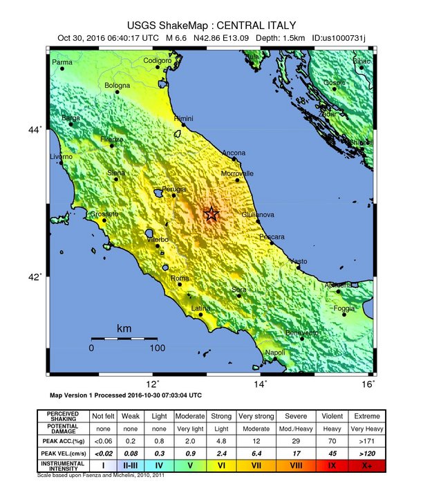 USGS issued a yellow alert for shaking-related fatalities and economic losses. Some casualties and damage are possible and the impact should be relatively localized. Past yellow alerts have required a local or regional level response.
Overall, the population in this region resides in structures that are a mix of vulnerable and earthquake resistant construction. The predominant vulnerable building types are unreinforced brick with mud and mid-rise nonductile concrete frame with infill construction.
Recent earthquakes in this area have caused secondary hazards such as landslides that might have contributed to losses.
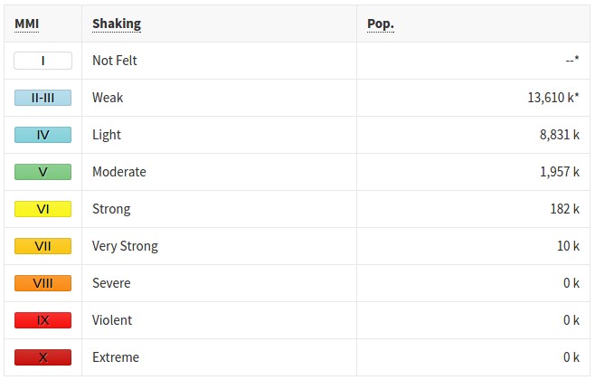
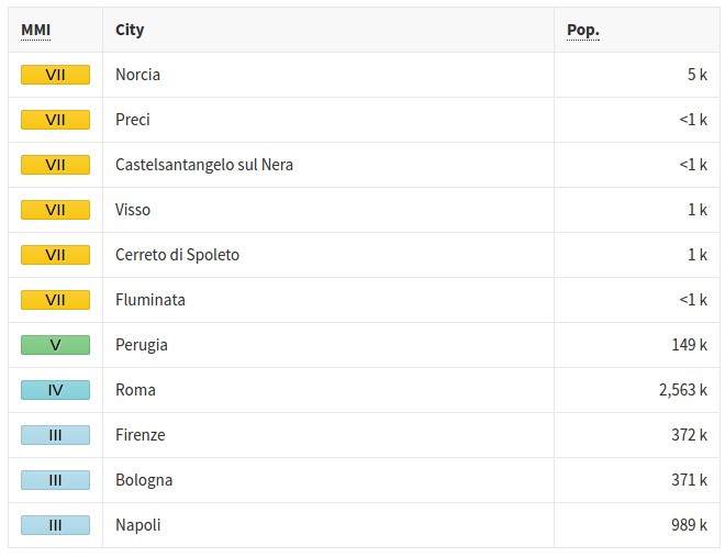
Estimated population exposure to earthquake shaking
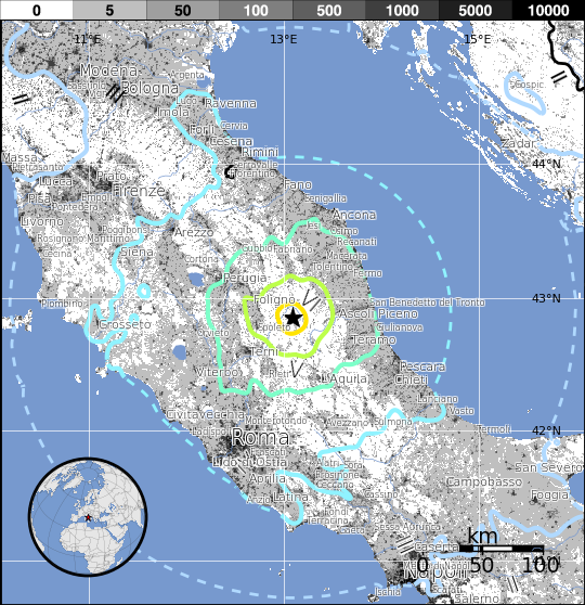
Selected cities exposed
More than 286 aftershocks were registered since M6.1 on October 26.
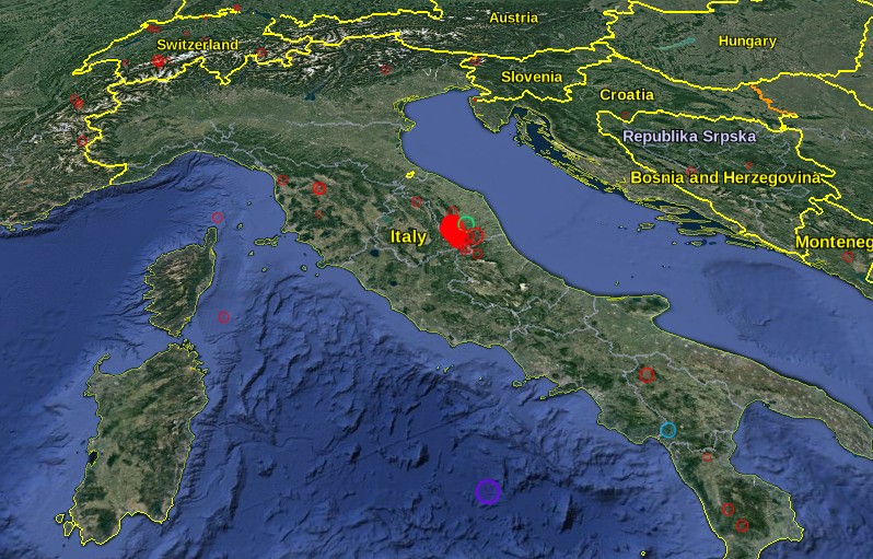
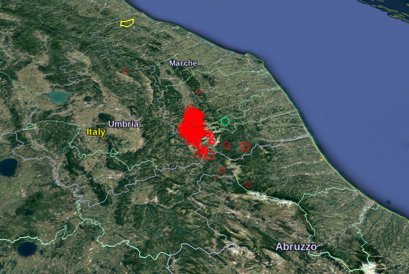
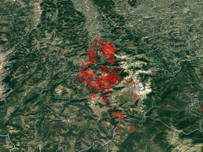
Credits: EMSC, Google
Seismotectonics of the Mediterranean region and vicinity
The Mediterranean region is seismically active due to the northward convergence (4-10 mm/yr) of the African plate with respect to the Eurasian plate along a complex plate boundary. This convergence began approximately 50 Ma and was associated with the closure of the Tethys Sea. The modern day remnant of the Tethys Sea is the Mediterranean Sea. The highest rates of seismicity in the Mediterranean region are found along the Hellenic subduction zone of southern Greece, along the North Anatolian Fault Zone of western Turkey and the Calabrian subduction zone of southern Italy. Local high rates of convergence at the Hellenic subduction zone (35mm/yr) are associated with back-arc spreading throughout Greece and western Turkey above the subducting Mediterranean oceanic crust. Crustal normal faulting throughout this region is a manifestation of extensional tectonics associated with the back-arc spreading. The region of the Marmara Sea is a transition zone between this extensional regime, to the west, and the strike-slip regime of the North Anatolian Fault Zone, to the east. The North Anatolian Fault accommodates much of the right-lateral horizontal motion (23-24 mm/yr) between the Anatolian micro-plate and Eurasian plate as the Anatolian micro-plate is being pushed westward to further accommodate closure of the Mediterranean basin caused by the collision of the African and Arabian plates in southeastern Turkey. Subduction of the Mediterranean Sea floor beneath the Tyrrhenian Sea at the Calabrian subduction zone causes a significant zone of seismicity around Sicily and southern Italy. Active volcanoes are located above intermediate depth earthquakes in the Cyclades of the Aegean Sea and in southern Italy.
In the Mediterranean region there is a written record, several centuries long, documenting pre-instrumental seismicity (pre-20th century). Earthquakes have historically caused widespread damage across central and southern Greece, Cyprus, Sicily, Crete, the Nile Delta, Northern Libya, the Atlas Mountains of North Africa and the Iberian Peninsula. The 1903 M8.2 Kythera earthquake and the 1926 M7.8 Rhodes earthquakes are the largest instrumentally recorded Mediterranean earthquakes, both of which are associated with subduction zone tectonics. Between 1939 and 1999 a series of devastating M7+ strike-slip earthquakes propagated westward along the North Anatolian Fault Zone, beginning with the 1939 M7.8 Erzincan earthquake on the eastern end of the North Anatolian Fault system. The 1999 M7.6 Izmit earthquake, located on the westward end of the fault, struck one of Turkey's most densely populated and industrialized urban areas killing, more than 17,000 people. Although seismicity rates are comparatively low along the northern margin of the African continent, large destructive earthquakes have been recorded and reported from Morocco in the western Mediterranean, to the Dead Sea in the eastern Mediterranean. The 1980 M7.3 El Asnam earthquake was one of Africa's largest and most destructive earthquakes within the 20th century.
Large earthquakes throughout the Mediterranean region have also been known to produce significant and damaging tsunamis. One of the more prominent historical earthquakes within the region is the Lisbon earthquake of November 1, 1755, whose magnitude has been estimated from non-instrumental data to be about 8.0. The 1755 Lisbon earthquake is thought to have occurred within or near the Azores-Gibraltar transform fault, which defines the boundary between the African and Eurasian plates off the west coast of Morocco and Portugal. The earthquake is notable for both a large death toll of approximately 60,000 people and for generating a tsunami that swept up the Portuguese coast inundating coastal villages and Lisbon. An earthquake of approximately M8.0 near Sicily in 1693 generated a large tsunami wave that destroyed numerous towns along Sicily's east coast. The M7.2 December 28, 1908 Messina earthquake is the deadliest documented European earthquake. The combination of severe ground shaking and a local tsunami caused an estimated 60,000 to 120,000 fatalities.
The Watchers team and our contributors bring the latest on extreme weather, earthquakes, volcanic eruptions, space weather, and all things science. We're all about making sense of the natural world and keeping you informed on what’s happening. Got a tip or a question? Hit us up using the form at newstips!
Commenting rules and guidelines
We value the thoughts and opinions of our readers and welcome healthy discussions on our website. In order to maintain a respectful and positive community, we ask that all commenters follow these rules.