
Torrential downpours trigger extensive flooding in Nelson city and Tasman district, New Zealand
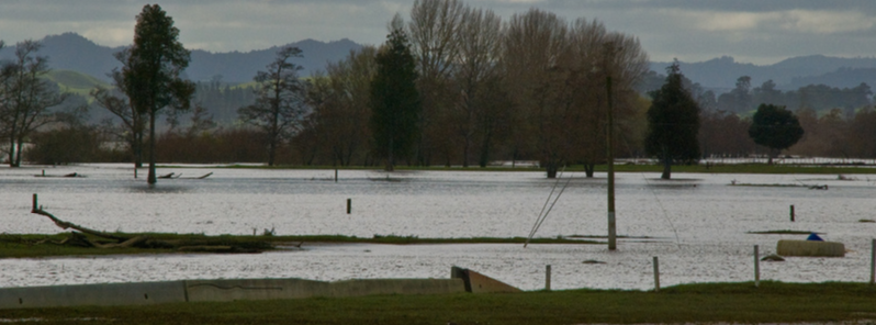
Featured image: Waikato River flood near Glen Murray, New Zealand, August 22, 2008. Image credit: Phillip Capper (Flickr-CC)
Heavy rainfall over the last two days triggered extensive surface flooding in parts of Nelson city and Tasman district in New Zealand on February 18, 2016, local civil defence and emergency authorities reported.
Reported flooding resulted from a period of severe weather over the last couple of days. 180 lightning strikes have been reported in the Central Otago district, and three of these struck the local houses. Rough seas and intense waves have been observed in the Auckland area.
More than 50 cm (19.7 inches) of rainfall was recorded during the last two days and significant amount of precipitation accumulated in the region's rivers. Wairoa River has reached a 25-year flood level and Anatoki River has reported a 10-year flood level while a one-year flood level has been observed at the Maitai River.
67.8 mm (2.7 inches) of rain was recorded at Nelson airport on February 17, according to the Meteorological Service of New Zealand. For comparison, the average rainfall total for February is 46 mm (1.8 inches).
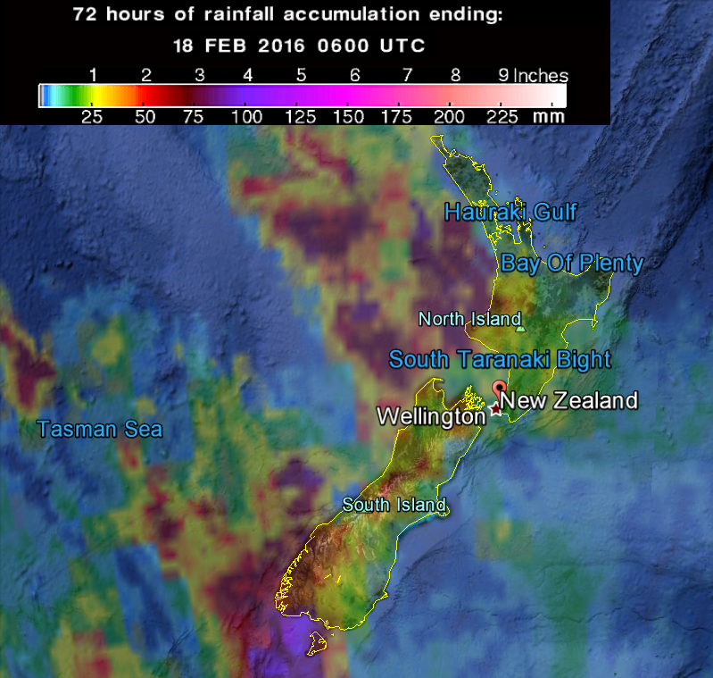
72-hr rainfall accumulation as observed by the GPM Core Observatory. Image credit: Google/NASA/JAXA GPM
Civil defence reported even more extreme rainfall in localised areas: "Parts of Nelson Tasman were drenched by more than half a meter (1.6 feet) of rain over the past 48 hours. 528 mm (20.8 inches) was recorded at the Paradise rain gauge in the hills behind Takaka."
The Anatoki River has overflowed parts of the Golden Bay, while Wairoa brought severe flooding to the Brightwater area where several roads had to be closed. Ferntown, Waitapu Splash, Upper Takaka and Lindsay's Bridge also reported flooding.
Luckily, no evacuations or injuries from weather-related incidents were reported. More detailed reported on the flood damage is expected, as the situation ic currently being assessed.
The New Zealand Meteorological Service issued a severe weather warning for the West Coast of the South Island and the Bay of Plenty and Rotorua on February 18: "A complex low over the Tasman Sea is expected to move east across the South Island today and early tomorrow, bringing heavy rain to the West Coast of the South Island and strong northwesterly winds over the South Island and lower North Island from this afternoon to Friday."
"Heavy rain and thunderstorms are expected about Fiordland, Westland and Buller through to Friday morning, where another 150-250 mm (5.9-9.8 inches) could accumulate on top of what has already fallen on the ranges of Westland. Heavy rain is forecast to continue in Bay of Plenty through Friday afternoon, where 150 mm (5.9 inches) could accumulate over a 30 hour period."
Commenting rules and guidelines
We value the thoughts and opinions of our readers and welcome healthy discussions on our website. In order to maintain a respectful and positive community, we ask that all commenters follow these rules.