
Severe Tropical Cyclone “Victor” affects Cook Islands with rainfall, winds and rough seas
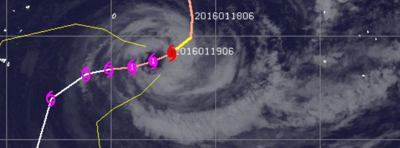
Featured image: Tropical Cyclone "Victor", January 19, 2016, 18:52 UTC. Image credit: UW-CIMSS
Tropical Cyclone "Victor" formed in the South Pacific Ocean on January 14 and is now equivalent to a Category 1 hurricane on the Saffir-Simpson wind scale. The system is not expected to hit the Cook Islands directly, but its effect will nevertheless be felt. The archipelago will be affected by the occasional thunderstorms accompanied with locally heavy rainfall, moderate winds, and rough seas.
Severe Tropical Cyclone "Victor" was located approximately 759.3 km (471.8 miles) west of Rarotonga and moving southwestward at 11 km/h (6.8 mph) on January 19 at 09:00 UTC, according to Joint Typhoon Warning Center (JTWC). The system was packing maximum sustained winds of 148.2 km/h (92 mph) with gusts up to 185.2 km/h (115 mph) at the time, and the maximum central pressure was estimated at 963 hPa.
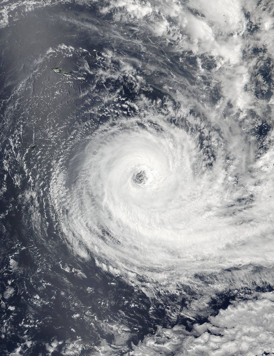
On January 19 at 01:00 UTC the VIIRS instrument aboard NASA-NOAA's Suomi NPP captured this image of a wide-eyed Tropical Cyclone Victor in the South Pacific Ocean. The eye was about 64 km (40 miles) wide.Image credits: NASA Goddard Rapid Response
Over the next 24 hours, the hurricane's strength will decrease and wind speeds will lower to 129.6 km/h (80.5 mph) with somewhat higher gusts of 166.7 km/h (103.6 mph).
Tropical Cyclone "Victor", January 19, 2016, 18:52 UTC. Image credit: UW-CIMSS
An approaching trough is expected to rapidly increase the vertical wind shear in the area which will significantly contribute to the weakening trend. Victor will begin a weak extratropical transition over the next 120 hours as it interacts with the baroclinic zone.
The system is expected to bypass the Cook Islands on its track. However, it will still affect the area with strong winds, high waves, and heavy rainfall.
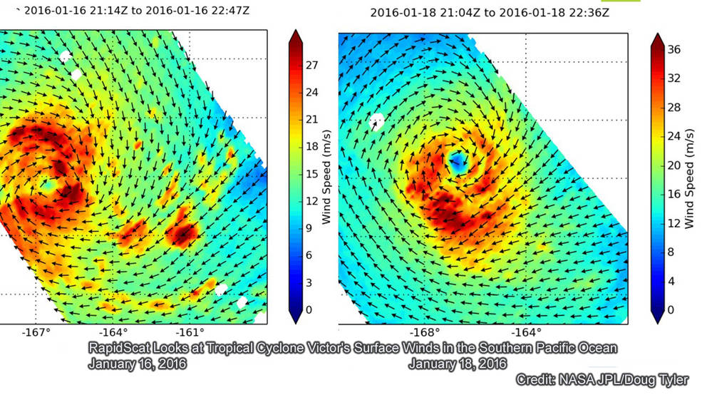
On January 16, 2016 (left) RapidScat measured Victor's strongest winds near 108 km/h (67 mph) in all quadrants except the western side. On January 18 (right) slightly weaker. By January 18 strongest winds had increased to 129.6 km/h (80.5 mph) in all but the northern side. Image credits: NASA JPL, Doug Tyler
According to Fiji Meteorological Service, Palmeston can expect strong north to northeast winds with speeds ranging between 37 and 55.6 km/h (23 and 34.5 mph), rough to very rough seas, and moderate northerly swells. The area could experience occasional, locally heavy rain and few thunderstorms.
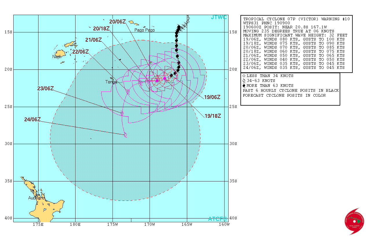
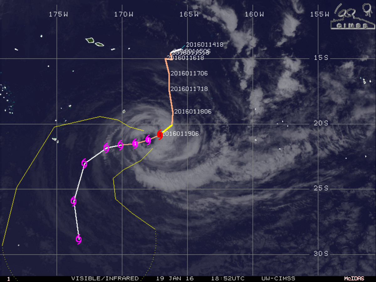
Tropical Cyclone "Victor" 5-day forecast track. Image credit: JTWC
The rest of Southern Cooks will see moderate to fresh northeast winds, rough seas, and moderate northeasterly swells along with occasional, locally heavy rain and squally thunderstorms.
Rarotonga can also expect occasional, locally heavy rain and few thunderstorms while the rest of the Northern Cooks will most likely see moderate north to northwest winds, fresh at times, moderate to rough seas and northerly swells.
Commenting rules and guidelines
We value the thoughts and opinions of our readers and welcome healthy discussions on our website. In order to maintain a respectful and positive community, we ask that all commenters follow these rules.