
Typhoon “Mujigae” hits China: tens of thousands evacuated, 120 missing in the Philippines
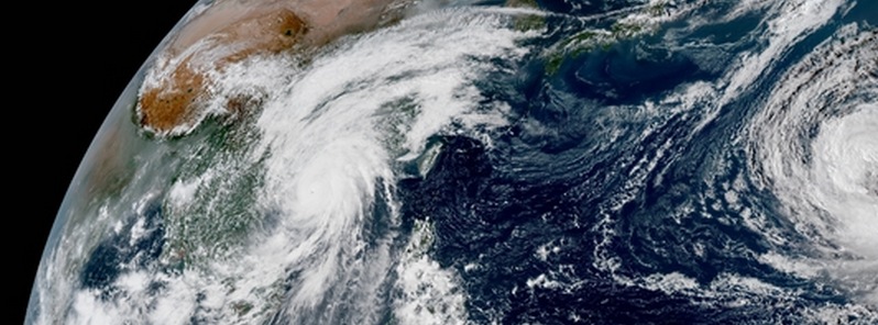
Featured image: Typhoon "Mujigae" at 05:50 UTC on October 4, 2015. Credit: JMA/Himawari-8.
Typhoon "Mujigae", known as Kabayan in the Philippines, was rapidly intensifying before it hit southern China early Sunday, October 4, 2015. Mujigae was bringing powerful winds and heavy rain as it approached China, prompting officials to issue red alerts. The storm left 120 fisherman missing in the Philippines.
Chinese officials say tens of thousands of people were evacuated in the country's south before the landfall near the city of Zhanjiang, Guangdong province. Mujigae was packing winds of 180 km/h (112 mph) at its center, and moving NW at about 19.3 km/h (12 mph), according to National Meteorological Center. There were no immediate reports of injuries.
Around 60 000 fishing boats were recalled to harbor in Hainan and coastal Guangdong province.
Category One Typhoon #Mujigae bearing down on Hong Kong and southeastern China. pic.twitter.com/12Yw2hfDWh
— UW-Madison CIMSS (@UWCIMSS) October 3, 2015
Typhoon #Mujigae over far southern Guangdong province, China after making landfall likely as 100 kt storm. pic.twitter.com/LthmYfvjEU
— Anthony Sagliani (@anthonywx) October 4, 2015
Typhoon #Mujigae has cleared eye prior to landfall. Satellite estimate at edge of Super Typhoon status (125-knots) pic.twitter.com/cQ0RNqW6Jq
— Ryan Maue (@RyanMaue) October 4, 2015
Meantime, the Philippine coast guard searched for 23 fishing boats with more than 120 fishermen lost when Mujigae hit the main island of Luzon, Reuters reports. "Nearly 30 fishing boats with more than 150 fishermen were returning from the South China Sea when Mujigae caught them at sea, the regional disaster and risk reduction agency said in a report on Sunday."

72hr rainfall accumulation by 00:00 UTC on October 4, 2015 with JTWC forecast track. Credit: Google Earth / NASA/JAXA GPM / JTWC
On October 1, the International Space Station made a pass over Tropical Storm Mujigae just before it made landfall in the Philippines and the RapidScat instrument measured the storm's surface winds. RapidScat saw maximum sustained winds in the northern quadrant of the storm near 24 meters per second (86.4 km/h/53.6 mph).

On October 1, RapidScat saw maximum sustained winds in the northern quadrant of the storm near 24 meters per second (86.4 km/h/53.6 mph). Credit: NASA JPL, Doug Tyler
MODIS instrument aboard NASA's Aqua satellite captured the following, visible image, of Tropical Storm "Mujigae" exiting the Philippines on October 2 at 05:25 UTC and moving through the South China Sea. No eye was visible in the image and the storm was almost completely over water, except for the eastern quadrant, which still blanketed part of Luzon.
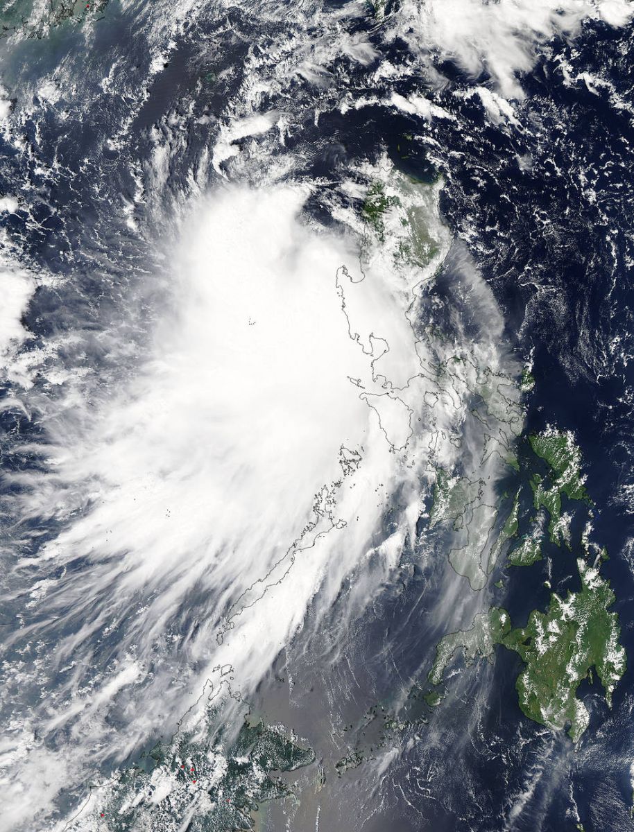
Image credit: NASA Aqua/MODIS
At 06:00 UTC on October 6, Typhoon "Mujigae" had maximum sustained winds of 212 km/h (132 mph), and wind gusts to 259 km/h (161 mph), according to JTWC.
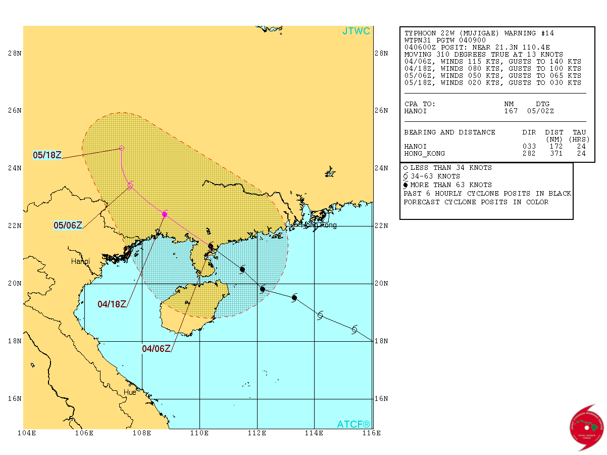
Typhoon "Mujigae" forecast track by JTWC on October 4, 2015.
I'm a dedicated researcher, journalist, and editor at The Watchers. With over 20 years of experience in the media industry, I specialize in hard science news, focusing on extreme weather, seismic and volcanic activity, space weather, and astronomy, including near-Earth objects and planetary defense strategies. You can reach me at teo /at/ watchers.news.
Commenting rules and guidelines
We value the thoughts and opinions of our readers and welcome healthy discussions on our website. In order to maintain a respectful and positive community, we ask that all commenters follow these rules.