
Very Severe Tropical Cyclone “Hudhud” targets India
.jpg)
Featured image: METEOSAT-7 IR satellite image of Indian Ocean at 21:00 UTC on October 10, 2014. (Credit: METEOSAT/UW-CIMSS)
Tropical Cyclone Hudhud formed in Northern Indian Ocean on October 8, 2014 and began to track westward across the Bay of Bengal. Now, as a very severe tropical cyclone, it is gaining more strength before landfall on October 12, 2014.
The Joint Typhoon Warning Center (JTWC) expects the cyclone to remain on a generally west-northwestward trajectory over the next couple of days. Hudhud is expected to intensify due favorable environment and peak around 185 km/h (115 mph) before landfall.
According to the Regional Specialized Meteorological Centre for Tropical Cyclones over the North Indian Ocean (RSMC), Hudhud is forecast to cross North Andhrapradesh coast around Visakhapatnam during the afternoon of October 12, 2014.
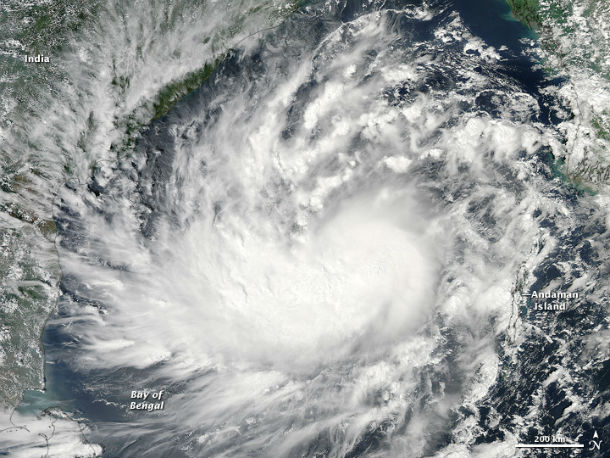
The Moderate Resolution Imaging Spectroradiometer (MODIS) on NASA's Aqua satellite acquired this natural-color image of Cyclone Hudhud at 07:45 UTC on October 9, 2014. (NASA image courtesy Jeff Schmaltz, LANCE MODIS Rapid Response Team at NASA GSFC. Caption by Mike Carlowicz)
.jpg)
INSAT-3D satellite images taken at 22:30 UTC on October 10, 2014. (Credit: IMD/INSAT)
RSMC expects wind speed reaching 50 to 60 km/h with gusts up to 70 km/h in area along and off the northern Andhra Pradesh coast and southern Odisha coast early on October 11. Wind speed is expected to increase to 130 to 140 km/h (80 to 87 mph) with higher gusts during October 12 along and off north Andhra coast and 80 to 90 km/h (50 to 56 mph) along and off south Odisha coast. JTWC expects top maximum sustained winds of 215 km/h (134 mph) with gusts up to 260 km/h (161 mph).
.png)
MTSAT RBTOP IR satellite image of center of TC Hudhud at 23:32 UTC on October 10, 2014. (Credit: NOAA/MTSAT)
.png)
Hudhud forecast track (Credit: JTWC)
Storm surge of about 1 to 2 meters (3.2 to 6.4 feet) above astronomical tide would inundate low lying areas of east Godavari, Visakhapatnam, Vijayanagaram and Srikakulam districts of north coastal Andhra Pradesh at the time of landfall. Hudhud is capable to cause widespread damage to infrastructure and disrupt power and communications in low-lying coastal areas. Land interaction will erode the system and it will rapidly dissipate.
India's eastern coast and Bangladesh are frequently hit by strong cyclones between April and November, causing deaths and widespread damage to property.
.jpg)
Satellite animations
- Storm-Centered Infrared (Meteosat 7; CIMSS)
- Storm-Centered Enhanced Infrared (Meteosat 7; CIMSS)
- Storm-Centered Water Vapor (Meteosat 7; CIMSS)
- Storm-Centered Visible (Meteosat 7; CIMSS)
- Storm-Centered Infrared (MTSAT2; NOAA/SSD)
- Storm-Centered Infrared (Aviation Color Enhancement) (MTSAT2; NOAA/SSD)
- Storm-Centered Water Vapor (MTSAT2; NOAA/SSD)
- Storm-Centered Visible (MTSAT2; NOAA/SSD)
- Storm-Centered Visible (Colorized) (MTSAT2; NOAA/SSD)
- Meteosat 7 Infrared
- Meteosat 7 Infrared (Color Background)
- Meteosat 7 Infrared (NHC Color Enhancement)
- Meteosat 7 Water Vapor
- Meteosat 7 Water Vapor (Color Background)
Commenting rules and guidelines
We value the thoughts and opinions of our readers and welcome healthy discussions on our website. In order to maintain a respectful and positive community, we ask that all commenters follow these rules.