
As Typhoon “Phanfone” leaves Japan, Typhoon “Vongfong” becomes a new threat
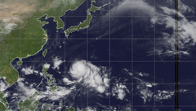
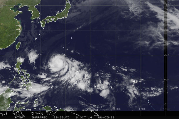
Featured image: MTSAT IR satellite image of West Pacific region taken at 22:30 UTC on October 6, 2104. (Credit: NOAA/UW-CIMSS)
Phanfone made landfall as Category 1 typhoon early on October 6, 2014 near Hamamatsu in Shizuoka Prefecture with maximum sustained winds of 134 km/h (82 mph). A peak gust of 164 km/h (102 mph) was recorded at Omaezaki, Shizuoka Prefecture.
.jpg)
The Moderate Resolution Imaging Spectroradiometer (MODIS) on NASA's Aqua satellite acquired this natural-color image of Typhoon Phanfone at 04:55 UTC on October 5, the day before making landfall. (Credit: NASA image by Jeff Schmaltz, LANCE/EOSDIS Rapid Response. Caption by Kathryn Hansen.)
The 667,000 people living in the mountainous regions of Shizuoka Prefecture were urged to evacuate to safer ground after three days of heavy rains and high threat of mudslides. In total, more than 2 million people across Japan were advised to evacuate as Phanfone came ashore.
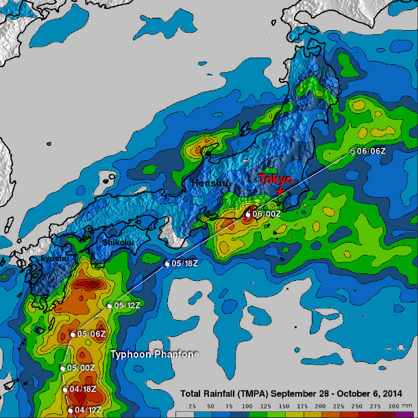
The TRMM- based, near-real time Multi-satellite Precipitation Analysis (TMPA) at the NASA Goddard Space Flight Center has been measuring the distribution of precipitation over the tropics. TMPA based rainfall totals are shown here for the period from September 28 to October 6, 2014 during which Phanfone formed east of Guam and traveled to Japan. The typhoon dropped rainfall over much of Japan but rainfall was particularly heavy near Phanfone's track along the southeastern coast of the islands. This analysis indicated that Phanfone dropped the greatest amount of rainfall in central Japan west of Tokyo where rainfall totals greater than 275 mm (10.8 inches) were found. This analysis found some rainfall totals above 300 mm (11.8 inches) over the Pacific Ocean southeast of Japan. (Credit: Hal Pierce/SSAI/NASA GSFC)
Typhoon turned northeast bringing torrential rain and strong winds to Tokyo metropolitan area before moving out to sea. According to Japan Meteorological Agency, some of the heaviest rainfall was recorded in Tokyo, which received 272 mm (10.71 inches) of rain, and Owase, which received 414 mm (16.30 inches) of rain. Kagiana received some of the heaviest rainfall – up to 80 mm (2.70 inches) of rain in just one hour. Heavy rainfall and strong winds from Phanfone also caused the suspension of search efforts for the missing hikers on Japan's Mount Ontake, which suddenly erupted in late September.
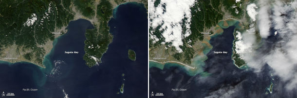
The intense rain and resulting runoff led to sediment plumes in Sugata Bay, visible in the natural-color image (right) acquired October 6 by the Moderate Resolution Imaging Spectroradiometer (MODIS) on NASA's Aqua satellite. Such plumes were not apparent on September 29 (left). (Credit: NASA Earth Observatory image by Jesse Allen, using data from the Land Atmosphere Near real-time Capability for EOS (LANCE). Caption by Kathryn Hansen.)
A press release from Kadena Air Base stated that one airman is confirmed dead and two more are missing after they were washed out to sea from the northwest coast of Okinawa on October 5, 2014. More than 50 people were reportedly injured across the country.
Phanfone is accelerating northeastward as it undergoes extra-tropical transition. Strong vertical wind shear and cooling sea surface temperatures will rapidly erode the system as it transitions into a storm force cold-core low.
.jpg)
Typhoon Vongfong a new threat to Japan
As Phanfone moves out, Typhoon Vongfong is aiming Japan over the coming days, potentially impacting areas already hit hard by Phanfone. Typhoon Vongfong hit Guam, Rota, Saipan and Tinian islands on October 5, 2014 as a Category 2 storm with 169 km/h (105 mph) winds. Typhoon Vongfong brought flooding rainfall and damaging winds to the northern Mariana Islands.
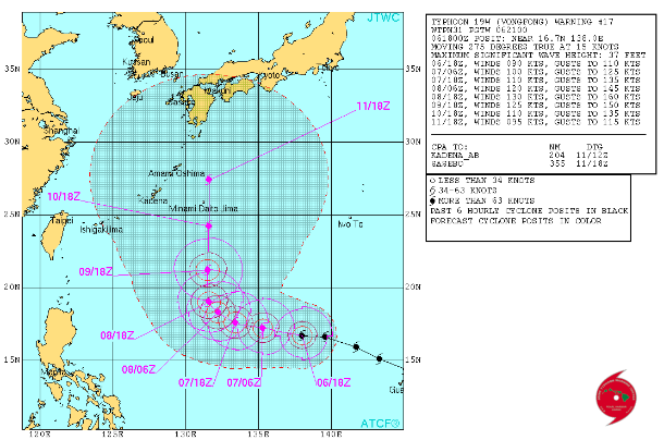
Typhoon Vongfong forecast track (Credit: JTWC)
Vongfong is expected to reach a super typhoon strength winds, near or over 240 km/h (150 mph) before nearing Japan mainland. Warm sea surface temperatures of 30°C (86°F) and moderate wind shear will fuel the system before cooler waters and higher wind shear weaken the system as it approaches Japan.
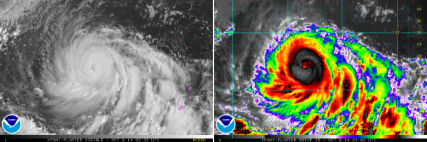
MTSAT IR imagery captured development of Typhoon Vongfong late on October 6, 2014. (Credit: NOAA/UW-CIMSS)
Satellite animations
- Storm-Centered Infrared (MTSAT2; NOAA/SSD)
- Storm-Centered Infrared (Aviation Color Enhancement) (MTSAT2; NOAA/SSD)
- Storm-Centered Water Vapor (MTSAT2; NOAA/SSD)
- Storm-Centered Visible (MTSAT2; NOAA/SSD)
- Storm-Centered Visible (Colorized) (MTSAT2; NOAA/SSD)
- Storm-Centered Infrared (MTSAT2; CIMSS)
- Storm-Centered Enhanced Infrared (MTSAT2; CIMSS)
- Storm-Centered Water Vapor (MTSAT2; CIMSS)
- Storm-Centered Visible (MTSAT2; CIMSS)
- Tropical West Pacific Infrared (MTSAT2; NOAA)
- Tropical West Pacific Enhanced Infrared (MTSAT2; NOAA)
- Tropical West Pacific Water Vapor (MTSAT2; NOAA)
- Tropical West Pacific Visible (MTSAT2; NOAA)
This is brilliant coverage.My daughter is married to a Japanese Doctor.They have a 2 year old and we go cold with fear as these typhoons unfold.No other country wants to make war with Japan so the weather vents it’s violence