
Super Typhoon “Hinnamnor” devours Tropical Depression “Gardo” – to impact Okinawa and South Korea
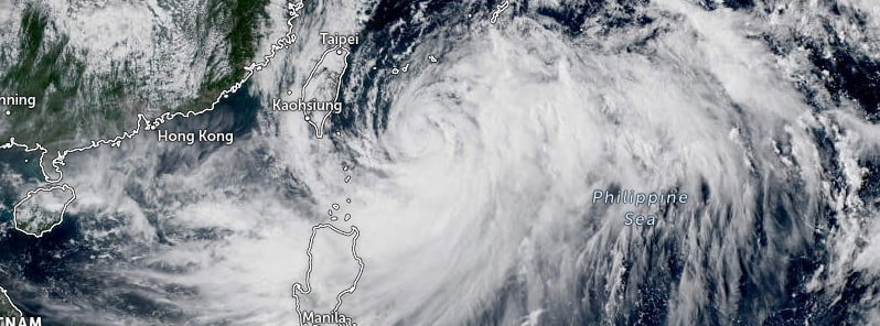
Featured image: Typhoon "Hinnamnor" at 06:10 UTC on September 2, 2022. Credit: JMA/Himawari-8, Zoom Earth, The Watchers
Typhoon “Hinnamnor” – the first super typhoon of the season and the strongest tropical cyclone of the year – merged with Tropical Depression “Gardo” on September 1, 2022, and continued moving toward Okinawa, Japan. The system is expected to turn toward South Korea and Western Japan on September 5.
At 09:00 UTC on September 2, the center of Typhoon “Hinnamnor” – known as Henry in the Philippines – was about 570 km (355 miles) SSW of Kadena Air Base, Okinawa, Japan.
It had maimum 10-minute sustained winds of 165 km/h (105 mph), with gusts up to 240 km/h (150 mph), and maximum 1-minute sustained winds of 150 km/h (90 mph).
The minimum central barometric pressure was 935 hPa, and the system was moving NNW at 11 km/h (6.9 mph).
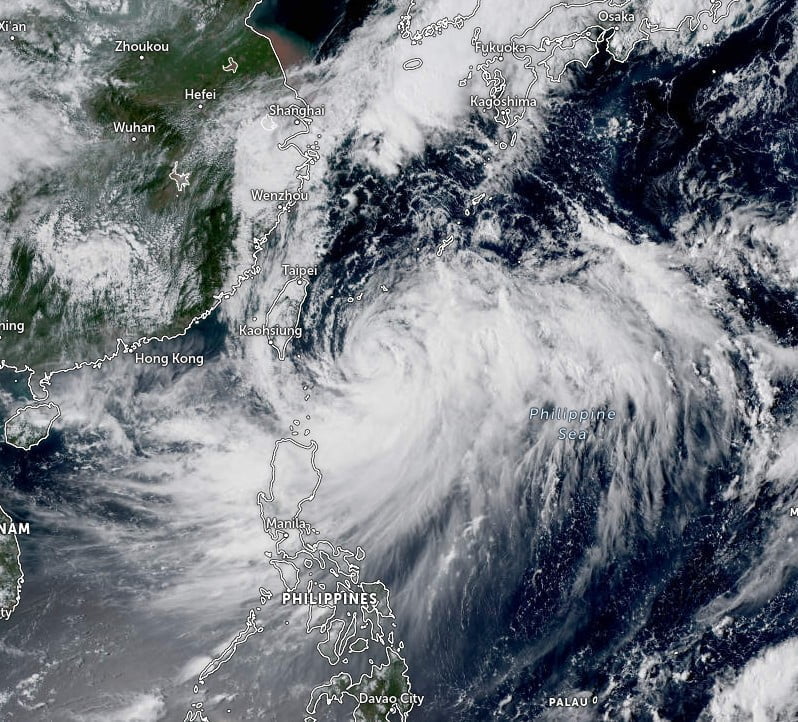
Animated radar imagery reveals a defined eye, while enhanced infrared satellite imagery shows deep convective banding wrapping into a raged, formative eye, JTWC forecasters said at 15:00 UTC today.1
The ASCAR-B image indicates gale-force winds over the northern semicircle extending just south of Ishigakijima and Miyakojima, Japan.
Gale-force winds are more extensive over the southern semicircle, extending about 370 km (230 miles) to the east and southeast.
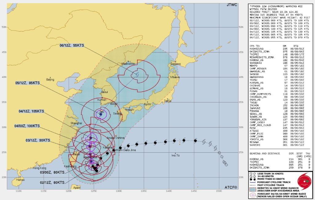
The system is forecast to re-intensify to a peak of 195 km/h / 120 mph (1-minute) by 15:00 UTC on September 4, according to the JTWC.
At around 00:00 UTC on September 5, Hinnamnor will recurve toward South Korea and Western Japan.
The system will commence extra-tropical transition near Cheju-do around 15:00 UTC on September 6 and will rapidly transition into an extra-tropical low in the Sea of Japan by 15:00 UTC on September 7.
The Japan Meteorological Agency (JMA) said the typhoon is forecast to approach the Sakishima Islands, including Miyako and Ishigaki, on Saturday evening (LT), September 3, with heavy rain, strong gusts and high waves.
The conditions are expected to worsen on Sunday, with winds of up to 235 km/h / 145 mph (10-minute) around the Sakishima Islands and up to 125 km/h (75 mph) affecting the prefecture’s largest island.2
Over the next 24 hours, the Sakishima Islands could get up to 300 mm (12 inches) of rain, Tokai region and Okinawa’s main island up to 150 mm (6 inches) and up to 100 mm (4 inches) in the Kinki Region.
References:
1 Typhoon 12W (Hinnamnor) – Prognostic reasoning- Issued at 15:00 UTC on September 2, 2022
2 Typhoon Hinnamnor to slam Okinawa islands through weekend – The Japan Times – September 2, 2022
I'm a dedicated researcher, journalist, and editor at The Watchers. With over 20 years of experience in the media industry, I specialize in hard science news, focusing on extreme weather, seismic and volcanic activity, space weather, and astronomy, including near-Earth objects and planetary defense strategies. You can reach me at teo /at/ watchers.news.
Commenting rules and guidelines
We value the thoughts and opinions of our readers and welcome healthy discussions on our website. In order to maintain a respectful and positive community, we ask that all commenters follow these rules.