
NOAA predicts significant harmful algal bloom in western Lake Erie this summer
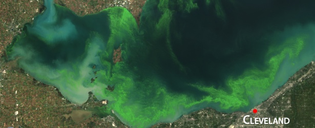
Featured image: Satellite image of 2011 bloom, the worst bloom in recent years, which impacted over half of the lake shore. Credit: MERIS/ESA, processed by NOAA/NOS/NCCOS
NOAA and its research partners predict that western Lake Erie will have a significant bloom of cyanobacteria, a toxic blue-green algae, during the 2014 bloom season in late summer. However, the predicted bloom is expected to be smaller than last year’s intense bloom, and considerably less than the record-setting 2011 bloom.
Bloom impacts will vary across the lake’s western basin and are classified by an estimate of both its concentration and how far it spreads.
Harmful algal blooms (HABs) were common in western Lake Erie between the 1960s and 1980s. After a lapse of nearly 20 years, blooms have been steadily increasing over the past decade. Since 2008, NOAA has issued weekly HAB bulletins for western Lake Erie through the National Centers for Coastal Ocean Science (NCCOS) to give warnings of bloom development. Also, this marks the third time NOAA has issued an annual outlook for western Lake Erie.
Satellite image of 2011 bloom, the worst bloom in recent years, which impacted over half of the lake shore. Credit: MERIS/ESA, processed by NOAA/NOS/NCCOS
“The reemergence of harmful algal blooms in Lake Erie is an ecological and economic setback for communities along the coast,” U.S. Representative Marcy Kaptur said. “NOAA, Ohio Sea Grant, OSU, Heidelberg University and University of Toledo are developing tools to predict and target phosphorus, which will help in the fight to restore balance to Lake Erie’s ecosystem, Ohio’s greatest natural resource.”
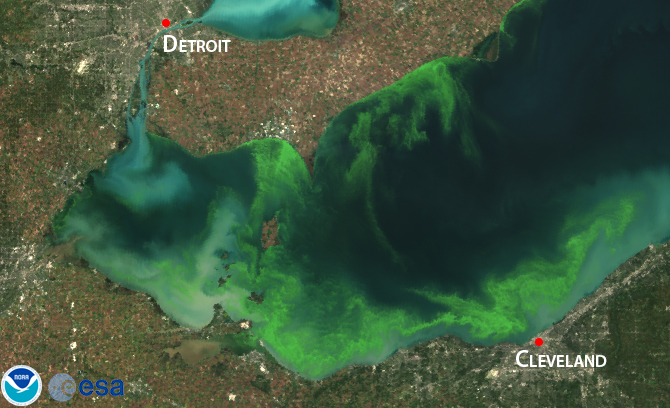
Satellite image of 2012 mild bloom 3. Credit: MODIS/NASA, processed by NOAA/NOS/NCCOS
“The Lake Erie harmful algal bloom forecast, combined with NOAA’s weekly HAB Bulletins, underscores the importance of having accessible and reliable environmental intelligence so the public and environmental health specialists can make informed decisions,” said Holly Bamford, assistant NOAA administrator for the National Ocean Service. “With this information, we can work collectively to understand harmful algal blooms and mitigate risk to humans and marine ecosystems.”
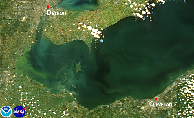
Satellite image of 2013 intense bloom, which was concentrated in the lake's western basin. Credit: MODIS/NASA, processed by NOAA/NOS/NCCOS
“This NOAA model, resulting from a great collaboration, has been incredibly valuable to us as we work to eliminate blooms to protect human health, the Lake Erie ecosystem and its coastal economy,” said Jeff Reutter, Ph.D., director of Ohio State University’s Sea Grant program and Stone Laboratory. “In Ohio, as part of the Ohio Phosphorus Task Force II, we have used information from the NOAA model to help us target reductions in the amount of phosphorus going into the lake that should help us greatly reduce or eliminate the HABs.”
The 2014 seasonal forecast used models developed by NCCOS scientists, the coastal science office for NOAA’s National Ocean Service. The forecast uses a 12-year Lake Erie nutrient flow data set, collected by Heidelberg University’s National Center for Water Quality Research, and analysis of satellite data from the European Space Agency’s ENVISAT and NASA’s Terra and Aqua satellites.
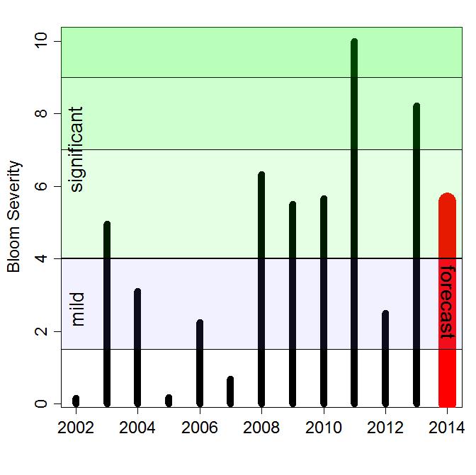
2014 forecast bloom severity compared to previous years based on NOAA and University of Toledo data. Credit: NOAA
Separately, a jointly funded University of Michigan Water Center and NOAA Great Lakes Environmental Research Laboratory (GLERL) independent HAB experimental model concurs with the 2014 forecast. In addition to the satellite monitoring, GLERL, Ohio State University’s Sea Grant program and Stone Laboratory, Heidelberg University, the University of Toledo, and Ohio EPA will be collecting key measurements from the lake as the summer progresses. Those results will provide valuable information to regional managers and assist NCCOS scientists in further refining the accuracy of this forecast’s models.
“Issuing and evaluating these seasonal forecasts improves our understanding of how the blooms form, which leads to strategies to reduce their impacts,” said Richard Stumpf, Ph.D., NOAA’s ecological forecasting applied research lead at NCCOS. “Our academic partnerships also support us in making improvements to the forecast, further helping managers monitor the bloom, and informing the public of where and when they can best use this great lake.”
Source: NOAA
The Watchers team and our contributors bring the latest on extreme weather, earthquakes, volcanic eruptions, space weather, and all things science. We're all about making sense of the natural world and keeping you informed on what’s happening. Got a tip or a question? Hit us up using the form at newstips!
Commenting rules and guidelines
We value the thoughts and opinions of our readers and welcome healthy discussions on our website. In order to maintain a respectful and positive community, we ask that all commenters follow these rules.