
Newborn Tropical Cyclone Amara strengthening as it nears La Reunion island
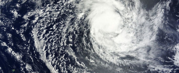
Image credit: NASA Terra MODIS
Third tropical depression of the Southern Indian Ocean cyclone season strengthened into tropical storm named Amara today. The Joint Typhoon Warning Center (JTWC) expects that Tropical Cyclone Amara will continue to strengthen over the next 5 days reaching hurricane-strength by December 22 as it nears La Reunion Island. They warn residents to closely monitor the progress.
At 09:00 UTC today, Amara's maximum sustained winds were near 62 km/h (35 knots/40 mph). The storm's course is forecast to change as a new steering influence comes into play.
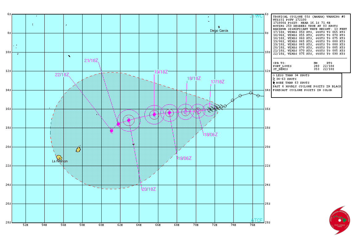
Tropical Cyclone Amara – Forecast track on December 17, 2013. Image credit: JTWC
According to latest JTWC warning, issued 21:00 UTC today, Tropical Cyclone 03S (Amara), was located approximately 544 NM (1000 km) south of Diego Garcia, and has tracked west-southwestward at 03 knots over the past six hours. Animated infrared satellite imagery depicts improving structure as the low level circulation center (llcc) has become tighter wrapped and deep convection has further improved.
Upper-level analysis indicates the system is now located underneath the subtropical ridge axis which is providing low (05-10 knots) vertical wind shear (vws) and good equatorward outflow although the poleward outflow channel has diminished. Tropical Cyclone Amara continues to move slowly as it is located in a weak steering environment, between two subtropical ridges.
The system is expected to begin to slowly accelerate to the west in the next 24 hours and remain on a this slow westward track under the influence of a building subtropical ridge to the southeast. By tau 96 a deep mid-latitude trough will pass south of the cyclone and erode the western periphery of the steering subtropical ridge.
During this time Amara will begin to slow down and dip southwest. Gradual intensification is expected under the favorable upper level conditions as well as supportive 26 to 27 degree sea surface temperatures (ssts). As it approaches the waters northeast of Mauritius, the combined effects of warmer ssts (28 degrees Celsius) and increased poleward outflow, should cause intensification to 75 knots. Maximum significant wave height at 18:00 UTC today was 3.9 meters (13 feet).
Tropical Cyclone Amara on December 17, 2013. Image credit: NASA Terra MODIS
NASA's TRMM and Aqua satellites flew overhead shortly after formation and provided visible and rainfall data on the intensifying storm.
TRMM captured data on rainfall rates occurring in Tropical Cyclone Amara on December 17 at 05:52 UTC and saw heavy rain occurring around the center and northwestern quadrant of the tropical storm. Rainfall rates in those areas topped 50 mm/2 inches per hour.
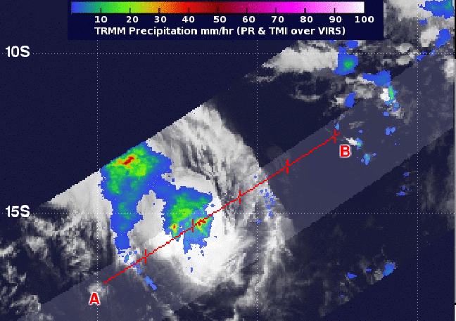
NASA's TRMM satellite captured this image of rainfall rates occurring in Tropical Cyclone Amara on December 17 at 05:52 UTC, and heavy rain (red) was happening in the center and northwestern quadrants. Image credit: NASA/SSAI, Hal Pierce
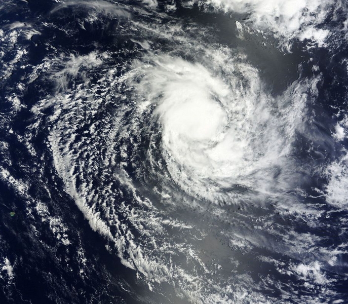
Aqua satellite passed over the storm and MODIS captured a visible image of newborn Tropical Cyclone Amara at 08:20 UTC. Image revealed the storm had good circulation.
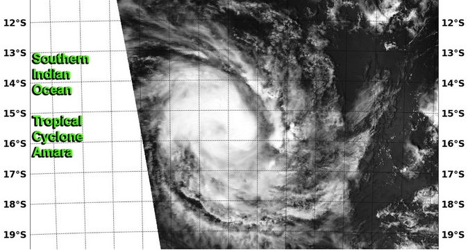
NASA's Aqua satellite captured this visible image of newborn Tropical Cyclone Amara in the Southern Indian Ocean on December 17 at 08:20 UTC. Image credit: NRL/NASA
In four days, by December 21, a strong mid-latitude trough, or elongated area of low pressure, is expected to pass south of the cyclone, slow it down and dip it toward the southwest (Goddard).
I'm a dedicated researcher, journalist, and editor at The Watchers. With over 20 years of experience in the media industry, I specialize in hard science news, focusing on extreme weather, seismic and volcanic activity, space weather, and astronomy, including near-Earth objects and planetary defense strategies. You can reach me at teo /at/ watchers.news.
Commenting rules and guidelines
We value the thoughts and opinions of our readers and welcome healthy discussions on our website. In order to maintain a respectful and positive community, we ask that all commenters follow these rules.