
Active volcanoes in the world: July 3 – July 9, 2013
Image credit: TW
This week, 4 volcanoes had new activity, ongoing activity was reported for 9 volcanoes. This report covers active volcanoes in the world recorded from July 3 – July 9, 2013 based on Smithsonian/USGS criteria.
New activity/unrest: | Popocatépetl, México | Shiveluch, Central Kamchatka (Russia) | Suwanose-jima, Ryukyu Islands (Japan) | Tori-shima, Japan
Ongoing activity: | Chirinkotan, Kuril Islands | Fuego, Guatemala | Gamkonora, Halmahera | Kilauea, Hawaii (USA) | Kizimen, Eastern Kamchatka (Russia) | Sakura-jima, Kyushu | Tolbachik, Central Kamchatka (Russia) | Veniaminof, Alaska Peninsula | White Island, New Zealand
The Weekly Volcanic Activity Report is a cooperative project between the Smithsonian's Global Volcanism Program and the US Geological Survey's Volcano Hazards Program. Updated by 2300 UTC every Wednesday, notices of volcanic activity posted on these pages are preliminary and subject to change as events are studied in more detail. This is not a comprehensive list of all of Earth's volcanoes erupting during the week, but rather a summary of activity at volcanoes that meet criteria discussed in detail in the "Criteria and Disclaimers" section. Carefully reviewed, detailed reports on various volcanoes are published monthly in the Bulletin of the Global Volcanism Network.
New activity/unrest
POPOCATEPETL, México
19.023°N, 98.622°W; summit elev. 5426 m
CENAPRED reported that on 3 July the seismic network detected 84 emissions from Popocatépetl. Diffuse ash plumes at 0705 and 0825 rose almost 2 km above the crater. Starting at 1742 tremor was accompanied by persistent emissions of gas and ash that rose 3.5 km. Incandescent tephra was ejected short distances onto the N and E flanks. During 3-4 July tremor and 99 emissions were detected, and incandescence from the crater was observed. Steam-and-gas plumes continued to rise above the crater and incandescent tephra was ejected onto the N and E flanks. According to news articles, multiple airlines canceled 47 flights to and from the México City (65 km NW) and Toluca (105 km WNW) airports on 4 July. Flights resumed later that day. Ash fell in areas as far as México City (70 km NW).
Gas, steam, and ash plumes drifted NW on 5 July, and almost continuous tremor was recorded. CENAPRED staff, with support of the Ministry of the Navy of México, conducted an overflight and observed continuously ejected incandescent tephra deposited at most 1.5 km away on almost all flanks, and an ash plume that rose 2 km. Cloud cover often obscured visual observations. A news article stated that four airlines canceled a total of 17 flights.
.jpg)
Infrared image captured on July 5, 2013 showing the explosions at Popocatepetl(Credit: CENAPRED)
On 6 July low-frequency, high-amplitude tremor was accompanied by gas, steam, and ash emissions that rose 2 km and drifted NW. At 1330 the low-frequency tremor amplitude decreased, followed by diminishing emissions of gas and ash which drifted NW. The National Coordination of Civil Protection (CNPC) of the Ministry of Interior (SEGOB), CENAPRED, and Scientific Advisory Committee raised the Alert Level to Yellow, Phase Three. The public was reminded not to approach the crater within a 12-km radius. Later that day gas-and-ash plumes rose 3 km and drifted NW. Three explosions were detected, but cloud cover prevented visual confirmation. News articles noted ash again in parts of México City; ash accumulation was much greater in areas closer to the volcano.
During 7-9 July tremor was accompanied by persistent emissions of steam, gas, and small amounts of ash that drifted WSW and NW; cloud cover continued to hinder visual observations. Three explosions increased gas-and-ash emissions. Incandescence and ejected incandescent tephra were sometimes observed. During an overflight on 7 July, scientists observed that a new lava dome, 250 m in diameter, had recently formed in the crater. Explosions on 8 July generated ash plumes that rose 1 km and drifted NW, and explosions on 9 July generated an ash plume that rose 1.5 km and drifted SW.
Geologic summary: Popocatépetl, whose name is the Aztec word for smoking mountain, towers to 5,426 m 70 km SE of Mexico City and is North America's second-highest volcano. Frequent historical eruptions have been recorded since the beginning of the Spanish colonial era. A small eruption on 21 December 1994 ended five decades of quiescence. Since 1996 small lava domes have incrementally been constructed within the summit crater and destroyed by explosive eruptions. Intermittent small-to-moderate gas-and-ash eruptions have continued, occasionally producing ashfall in neighboring towns and villages.
SHIVELUCH, Central Kamchatka (Russia)
56.653°N, 161.360°E; summit elev. 3283 m
Based on visual observations and analyses of satellite data, KVERT reported that during 28 June-5 July a viscous lava flow effused on the N flank of Shiveluch's lava dome, accompanied by hot avalanches, incandescence, and fumarolic activity. Ash plumes as high as 6 km (19,700 ft) a.s.l. were observed during 27-28 June and 3 July. Satellite images detected a daily thermal anomaly, and ash plumes that drifted 35 km SE on 3 July. The Aviation Color Code remained at Orange.
Geologic summary: The high, isolated massif of Shiveluch volcano (also spelled Sheveluch) rises above the lowlands NNE of the Kliuchevskaya volcano group and forms one of Kamchatka's largest and most active volcanoes. The currently active Molodoy Shiveluch lava-dome complex was constructed during the Holocene within a large breached caldera formed by collapse of the massive late-Pleistocene Strary Shiveluch volcano. At least 60 large eruptions of Shiveluch have occurred during the Holocene, making it the most vigorous andesitic volcano of the Kuril-Kamchatka arc. Frequent collapses of lava-dome complexes, most recently in 1964, have produced large debris avalanches whose deposits cover much of the floor of the breached caldera. Intermittent explosive eruptions began in the 1990s from a new lava dome that began growing in 1980. The largest historical eruptions from Shiveluch occurred in 1854 and 1964.
SUWANOSE-JIMA, Ryukyu Islands (Japan)
29.635°N, 129.716°E; summit elev. 799 m
According to the Tokyo VAAC, a pilot observed an ash plume from Suwanose-jima that rose to an altitude of 1.5 km (5,000 ft) a.s.l. Ash was not detected in satellite images.
Geologic summary: The 8-km-long, spindle-shaped island of Suwanose-jima in the northern Ryukyu Islands consists of an andesitic stratovolcano with two historically active summit craters. Only about 50 persons live on the sparsely populated island. The summit of the volcano is truncated by a large breached crater extending to the sea on the east flank that was formed by edifice collapse. Suwanose-jima, one of Japan's most frequently active volcanoes, was in a state of intermittent Strombolian activity from On-take, the NE summit crater, that began in 1949 and lasted nearly a half century. The largest historical eruption took place in 1813-14, when thick scoria deposits blanketed residential areas, after which the island was uninhabited for about 70 years. The SW crater produced lava flows that reached the western coast in 1813, and lava flows reached the eastern coast of the island in 1884.
TORI-SHIMA, Izu Islands (Japan)
30.48°N, 140.32°E; summit elev. 403 m
According to the Tokyo VAAC a pilot observed an ash plume from Tori-shima drifting at an altitude of 2.1 km (7,000 ft) a.s.l. on 6 July.
Geologic summary: The circular, 2.7-km-wide island of Tori-shima is capped by an unvegetated summit cone formed during an eruption in 1939. Fresh lava flows from this eruption form part of the northern coastline. The volcano is also referred to as Izu-Tori-shima to distinguish it from the several other Japanese island volcanoes called Tori-shima ("Bird Island"). The main cone is truncated by a 1.5-km-wide caldera that contains two central cones, of which 403-m-high Iwo-dake is the highest. Historical eruptions have also occurred from flank vents near the N coast and offshore submarine vents. A 6-8 km submarine caldera lies immediately to the N of Tori-shima.
Ongoing activity
CHIRINKOTAN, Kuril Islands
48.980°N, 153.480°E; summit elev. 724 m
Based on analysis of satellite images, SVERT reported that steam-and-gas emissions from Chirinkotan were observed on 3 July and a thermal anomaly was detected on 4 July. The Aviation Color Code remained at Yellow.
Geologic summary: The small, mostly unvegetated 3-km-wide island of Chirinkotan occupies the far end of an E-W-trending volcanic chain that extends nearly 50 km west of the central part of the main Kuril Islands arc. Chirinkotan is the emergent summit of a volcano that rises 3000 m from the floor of the Kuril Basin. A small 1-km-wide caldera about 300-400 m deep is open to the SE. Lava flows from a cone within the breached crater reached the north shore of the island. Historical eruptions have been recorded at Chirinkotan since the 18th century. Fresh lava flows also descended the SE flank of Chirinkotan during an eruption in the 1880s that was observed by the English fur trader Captain Snow.
FUEGO, Guatemala
14.473°N, 90.880°W; summit elev. 3763 m
INSIVUMEH reported that explosions from Fuego during 3-9 July generated ash plumes that rose 100-750 m above the crater and drifted 4-10 km W and NW on most days. During 4-5 and 8-9 July shock waves vibrated structures in areas including Sangre de Cristo (8 km WSW), Panimaché (8 km SW), and Morelia (9 km SW). On 5 July lahars descended the Las Lajas and El Jute drainages (SE), carrying blocks up to 50 cm in diameter.
Geologic summary: Volcán Fuego, one of Central America's most active volcanoes, is one of three large stratovolcanoes overlooking Guatemala's former capital, Antigua. The scarp of an older edifice, Meseta, lies between 3,763-m-high Fuego and its twin volcano to the N, Acatenango. Construction of Meseta volcano continued until the late Pleistocene or early Holocene, after which growth of the modern Fuego volcano continued the southward migration of volcanism that began at Acatenango. Frequent vigorous historical eruptions have been recorded at Fuego since the onset of the Spanish era in 1524, and have produced major ashfalls, along with occasional pyroclastic flows and lava flows. The last major explosive eruption from Fuego took place in 1974, producing spectacular pyroclastic flows visible from Antigua.
GAMKONORA, Halmahera
1.38°N, 127.53°E; summit elev. 1635 m
CVGHM reported that observers at the Gamkonora observation post in Gamsungi (6 km NW), West Halmahera, reported that during 27 May-30 June diffuse white plumes rose up to 300 m above the crater rim. Seismicity declined overall, but a seismic crisis characterized by continuous tremor was detected on 10 June; tremor was not detected during 13-30 June. The Alert Level was lowered to 2 (on a scale of 1-4) on 1 July. Residents and tourists were asked not to venture near the crater within a radius of 1.5 km.
Geologic summary: The shifting of eruption centers on Gamkonora, at 1635 m the highest peak of Halmahera, has produced an elongated series of summit craters along a N-S trending rift. Youthful-looking lava flows originate near the cones of Gunung Alon and Popolojo, south of Gamkonora. Since its first recorded eruption in the 16th century, Gamkonora has typically produced small-to-moderate explosive eruptions. Its largest historical eruption, in 1673, was accompanied by tsunamis that inundated villages.
KILAUEA, Hawaii (USA)
19.421°N, 155.287°W; summit elev. 1222 m
During 3-9 July HVO reported that the circulating lava lake occasionally rose and fell in the deep pit within Kilauea's Halema'uma'u Crater. The plume from the vent continued to deposit variable amounts of ash, spatter, and Pele's hair onto nearby areas.
At Pu'u 'O'o Crater, glow emanated from three spatter cones and a small lava pond on the E part of the crater floor. Branches of the Kahauale’a 2 lava flow, fed by the NE spatter cone, were active as far N as 2.6 km and as far NNW as 1.9 km, and burned forest in both areas. Peace Day activity, fed by lava tubes extending from Pu'u 'O'o, consisted of some breakout activity on the pali and coastal plain, and ocean entries at locations inside and outside the National Park boundary.
Geologic summary: Kilauea, one of five coalescing volcanoes that comprise the island of Hawaii, is one of the world's most active volcanoes. Eruptions at Kilauea originate primarily from the summit caldera or along one of the lengthy E and SW rift zones that extend from the caldera to the sea. About 90% of the surface of Kilauea is formed of lava flows less than about 1,100 years old; 70% of the volcano's surface is younger than 600 years. A long-term eruption from the East rift zone that began in 1983 has produced lava flows covering more than 100 sq km, destroying nearly 200 houses and adding new coastline to the island.
KIZIMEN, Eastern Kamchatka (Russia)
55.130°N, 160.32°E; summit elev. 2376 m
KVERT reported that during 28 June-5 July moderate seismic activity continued at Kizimen. Video and satellite data showed that lava continued to extrude from the summit, producing incandescence, strong gas-and-steam activity, and hot avalanches on the W and E flanks. A thermal anomaly was detected in satellite images on 28 June, and during 1 and 3-4 July. The Aviation Color Code remained at Orange.
Geologic summary: Kizimen is an isolated, conical stratovolcano that is morphologically similar to Mount St. Helens prior to its 1980 eruption. The summit of Kizimen consists of overlapping lava domes, and blocky lava flows descend the flanks of the volcano, which is the westernmost of a volcanic chain north of Kronotsky volcano. The 2,376-m-high Kizimen was formed during four eruptive cycles beginning about 12,000 years ago and lasting 2,000-3,500 years. The largest eruptions took place about 10,000 and 8300-8400 years ago, and three periods of longterm lava-dome growth have occurred. The latest eruptive cycle began about 3,000 years ago with a large explosion and was followed by lava-dome growth lasting intermittently about 1,000 years. An explosive eruption about 1,100 years ago produced a lateral blast and created a 1.0 x 0.7 km wide crater breached to the NE, inside which a small lava dome (the fourth at Kizimen) has grown. A single explosive eruption, during 1927-28, has been recorded in historical time.
SAKURA-JIMA, Kyushu
31.585°N, 130.657°E; summit elev. 1117 m
JMA reported that two explosions at Sakura-jima's Showa Crater were detected during 5-8 July; cloud cover prevented visual observations of the crater. Crater incandescence was occasionally detected at night. Based on information from JMA, the Tokyo VAAC reported that during 8-9 July explosions generated plumes that rose to altitudes of 1.8-3.7 km (6,000-12,000 ft) a.s.l. and drifted NE, E, and SE.
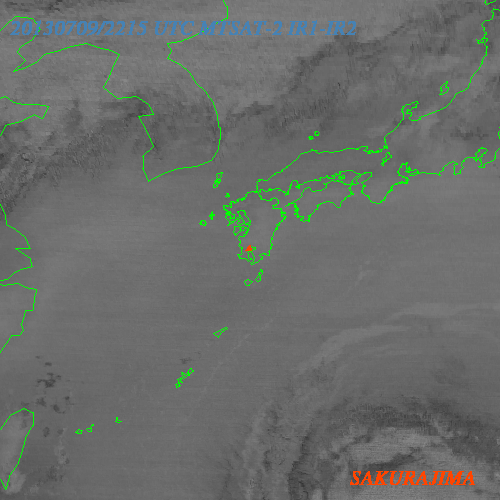
Satellite split image of Sakurajima volcano, on July 09, 2013 (Credit: Tokyo VAAC, MTSAT)
Geologic summary: Sakura-jima, one of Japan's most active volcanoes, is a post-caldera cone of the Aira caldera at the northern half of Kagoshima Bay. Eruption of the voluminous Ito pyroclastic flow was associated with the formation of the 17 x 23-km-wide Aira caldera about 22,000 years ago. The construction of Sakura-jima began about 13,000 years ago and built an island that was finally joined to the Osumi Peninsula during the major explosive and effusive eruption of 1914. Activity at the Kita-dake summit cone ended about 4,850 years ago, after which eruptions took place at Minami-dake. Frequent historical eruptions, recorded since the 8th century, have deposited ash on Kagoshima, one of Kyushu's largest cities, located across Kagoshima Bay only 8 km from the summit. The largest historical eruption took place during 1471-76.
TOLBACHIK, Central Kamchatka (Russia)
55.830°N, 160.330°E; summit elev. 3682 m
KVERT reported that the S fissure along the W side of Tolbachinsky Dol, a lava plateau on the SW side of Tolbachik, continued to produce very fluid lava flows during 28 June-5 July that traveled to the W, S, and E sides of the plateau. Cinder cones continued to grow along the S fissure and weak gas-and-steam plumes were observed. A large thermal anomaly on the N part of Tolbachinsky Dol was visible daily in satellite imagery. The Aviation Color Code remained at Orange.
Geologic summary: The massive Tolbachik basaltic volcano is located at the southern end of the dominantly andesitic Kliuchevskaya volcano group. The Tolbachik massif is composed of two overlapping, but morphologically dissimilar volcanoes. The flat-topped Plosky Tolbachik shield volcano with its nested Holocene Hawaiian-type calderas up to 3 km in diameter is located east of the older and higher sharp-topped Ostry Tolbachik stratovolcano. The summit caldera at Plosky Tolbachik was formed in association with major lava effusion about 6500 years ago and simultaneously with a major southward-directed sector collapse of Ostry Tolbachik volcano. Lengthy rift zones extending NE and SSW of the volcano have erupted voluminous basaltic lava flows during the Holocene, with activity during the past two thousand years being confined to the narrow axial zone of the rifts. The 1975-76 eruption originating from the SSW-flank fissure system and the summit was the largest historical basaltic eruption in Kamchatka.
Source: GVP
it semms like things r really got hot on our planet with all this new activity going on