
Shallow M 6.0 earthquake hit Honshu, Japan
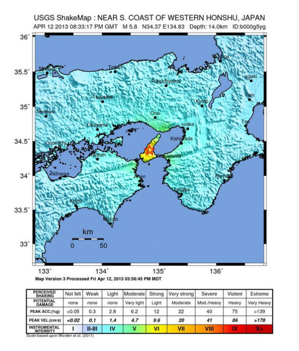
Image credit: USGS Shake Map
Japan Meteorological Agency (JMA) registered M 6.0 earthquake near Sumoto at Honshu Island, Japan, on April 12, 2013 at 20:33 UTC (April 13, 2013 at 05:33 local time). The epicenter was 9 km (5 miles) NW of Sumoto, Japan and 20 km (12 miles) NNE of Fukura, Japan at coordinates 34.369°N, 134.831°E. JMA reported depth of 10 km.
USGS and EMSC reported M 5.8 at the same depth. There was no tsunami warning issued.
FDMA Japan reports that 6 people have been reported injured so far.
USGS shake intensity map (Credit: USGS)
USGS PAGER issued Yellow alert for estimated economic losses (42%). Past events with this alert level have required a local or regional level response. Millions of people have felt this earthquake.
Western Honshu recorded landslides, fires and liquefaction after series of recent earthquakes in this area.
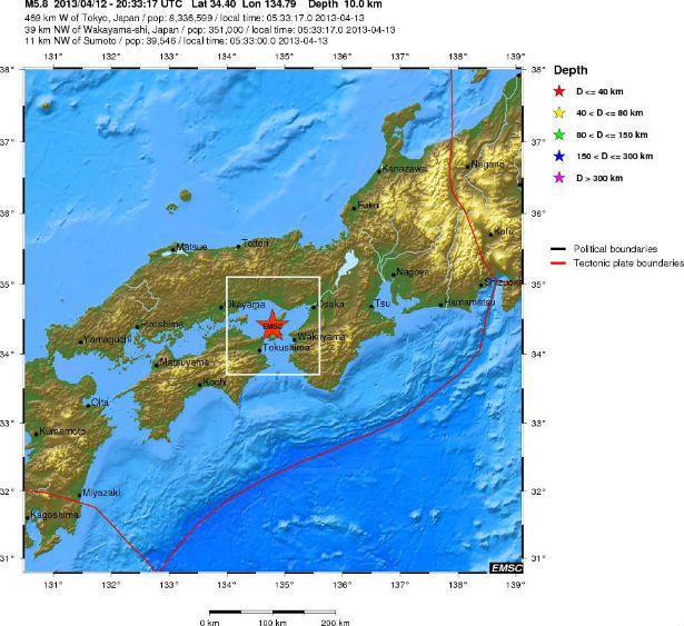 Regional view map (Credit: EMSC)
Tectonic summary by USGS
The April 12, 2013 (UTC) M5.8 earthquake in southern Japan occurred as result of east-west oriented thrust type motion near the junction of the predominantly right-lateral Arima-Takatsuki and Median Tectonic Lines between the islands of Shikoku and Honshu. The depth and style of faulting is consistent with shortening of the shallow continental crust due to slip partitioning in the upper plate of the Nankai Subduction Zone.
The broad scale tectonics of southern Japan are dominated by active subduction of oceanic crust beneath the Eurasian Plate. In the region of the April 12 event, the Philippine oceanic plate subducts northwestward beneath the islands of southern Honshu, Kyushu, and Shikoku at a rate of 66mm/yr, forming the Nankai Subduction Zone. In many subduction zone environments, active plate convergence is partitioned between thrust-type motion perpendicular to the subduction zone and strike-slip motion parallel to the subduction zone in the upper plate. Preliminary source location and mechanisms for the April 12 event are consistent with trench-parallel faulting in the vicinity of the Arima-Takatsuki and Niigata-Kobe fault zones, which accommodate ~7mm/yr and ~6mm/yr of right-lateral fault motion respectively. While the events mechanism is consistent with thrust-type motion, thrust- and normal-type earthquakes are common along major strike slip faults. To the north of the Nankai Subduction Zone, a complex plate triple junction forms before the Pacific oceanic plate subducts westward beneath northern Honshu and Hokkaido. This region was the source of the March 2011 Mw9.0 Tohoku-Oki earthquake and tsunami.
Seven events between Mw6.0 and 6.9 have occurred within 300km of the April 12 event in the past 40 years. The April 12 event occurred about 30 km from the 1995 Mw6.9 Kobe earthquake, which resulted in 6,434 deaths and ~$US100 billion in damage.
Seismotectonics of Japan and Vicinity
Japan and the surrounding islands straddle four major tectonic plates: Pacific plate; North America plate; Eurasia plate; and Philippine Sea plate. The Pacific plate is subducted into the mantle, beneath Hokkaido and northern Honshu, along the eastern margin of the Okhotsk microplate, a proposed subdivision of the North America plate. Farther south, the Pacific plate is subducted beneath volcanic islands along the eastern margin of the Philippine Sea plate. This 2,200 km-long zone of subduction of the Pacific plate is responsible for the creation of the deep offshore Ogasawara and Japan trenches as well as parallel chains of islands and volcanoes, typical of Circumpacific island arcs. Similarly, the Philippine Sea plate is itself subducting under the Eurasia plate along a zone, extending from Taiwan to southern Honshu that comprises the Ryukyu Islands and the Nansei-Shoto trench.
Subduction zones at the Japanese island arcs are geologically complex and produce numerous earthquakes from multiple sources. Deformation of the overriding plates generates shallow crustal earthquakes, whereas slip at the interface of the plates generates interplate earthquakes that extend from near the base of the trench to depths of 40 to 60 km. At greater depths, Japanese arc earthquakes occur within the subducting Pacific and Philippine Sea plates and can reach depths of nearly 700 km. Since 1900, three great earthquakes occurred off Japan and three north of Hokkaido. They are the M8.4 1933 Sanriku-oki earthquake, the M8.3 2003 Tokachi-oki earthquake, the M9.0 2011 Tohoku earthquake, the M8.4 1958 Etorofu earthquake, the M8.5 1963 Kuril earthquake, and the M8.3 1994 Shikotan earthquake. (USGS)
Commenting rules and guidelines
We value the thoughts and opinions of our readers and welcome healthy discussions on our website. In order to maintain a respectful and positive community, we ask that all commenters follow these rules.