
Active volcanoes in the world: April 3 – April 9, 2013
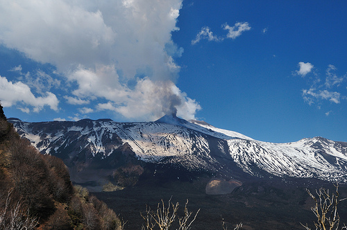
Image credit: gnuckx - CC BY 2.0
This week, 6 volcanoes had new activity, whereas ongoing activity was reported for 13 volcanoes. This report covers active volcanoes in the world recorded from April 3 – April 9, 2013 based on Smithsonian/USGS criteria.
New activity/unrest: | Grozny Group, Iturup Island | Karangetang
Ongoing activity: | Bagana, Bougainville | Batu Tara, Komba Island (Indonesia) | Chirpoi, Kuril Islands (Russia) | Etna, Sicily (Italy) | Karymsky, Eastern Kamchatka (Russia) | Kilauea, Hawaii (USA) | Kizimen, Eastern Kamchatka (Russia) | Lokon-Empung, Sulawesi | Paluweh, Lesser Sunda Islands (Indonesia) | Sabancaya, Perú | Sakura-jima, Kyushu | Shiveluch, Central Kamchatka (Russia) | Tolbachik, Central Kamchatka (Russia)
The Weekly Volcanic Activity Report is a cooperative project between the Smithsonian’s Global Volcanism Program and the US Geological Survey’s Volcano Hazards Program. Updated by 2300 UTC every Wednesday, notices of volcanic activity posted on these pages are preliminary and subject to change as events are studied in more detail. This is not a comprehensive list of all of Earth’s volcanoes erupting during the week, but rather a summary of activity at volcanoes that meet criteria discussed in detail in the “Criteria and Disclaimers” section. Carefully reviewed, detailed reports on various volcanoes are published monthly in the Bulletin of the Global Volcanism Network.
New activity/unrest
GROZNY GROUP, Iturup Island
45.026°N, 147.922°E; summit elev. 1211 m
SVERT reported that on 3 April at 0755 ash from Grozny Group fell in Kurilsk (23 km N) and Kitovy, producing deposits 2-3 mm thick. Cloud cover prevented observations of the volcano. The next day satellite images showed an ash plume that rose 3 km (10,000 ft) a.s.l. and drifted W and NW. The Aviation Color Code remained at Yellow.
Geologic summary: The Grozny volcano group in central Iturup Island contains the complex volcanoes of Ivan Grozny and Tebenkov. The former has a 3-3.5 km diameter caldera that is open to the south, where the large, 1158-m-high andesitic Grozny extrusion dome (also known as Etorofu-Yake-yama) was emplaced. Several other lava domes of Holocene age were constructed to the NE; extrusion of these domes has constricted a former lake in the northern side of the caldera to an extremely sinuous shoreline. The forested andesitic Tebenkov volcano, also known as Odamoi-san, lies immediately to the NE of the Grozny dome complex. The large Machekh crater, which displays strong fumarolic activity, lies immediately south of Tebenkov. Historical eruptions, the first of which took place in 1968, have been restricted to Ivan Grozny.
KARANGETANG , Siau I
2.78°N, 125.40°E; summit elev. 1784 m
Based on analyses of satellite imagery and wind data, the Darwin VAAC reported that on 9 April an ash plume from Karangetang rose to an altitude of 4.3 km (14,000 ft) a.s.l. and drifted over 45 km WNW. According to a news article, pahoehoe lava flows traveled 150 m and rock avalanches traveled 2 km down the flanks on that same day.
Geologic summary: Karangetang (also known as Api Siau) lies at the northern end of the island of Siau, N of Sulawesi, and contains five summit craters strung along a N-S line. One of Indonesia’s most active volcanoes, Karangetang has had more than 40 recorded eruptions since 1675. Twentieth-century eruptions have included frequent explosions, sometimes accompanied by pyroclastic flows and lahars.
LASCAR, Northern Chile
23.37°S, 67.73°W; summit elev. 5592 m
OVDAS-SERNAGEOMIN reported that during March a web camera monitoring Láscar recorded white gas plumes rising 600 m above the crater. At night during 2-4 April incandescence from the crater was observed. On 3 April increased emissions from the crater fluctuated from white to gray, indicating possible ash. Plumes rose 320 m and drifted SE. Seismicity remained at normal levels during the increased emissions. On 5 April the Alert Level was raised to Yellow.
Geologic summary: Lascar is the most active volcano of the northern Chilean Andes. The andesitic-to-dacitic stratovolcano contains six overlapping summit craters and lies 5 km W of an older, higher stratovolcano, Volcán Aguas Calientes. Lascar consists of two major edifices; activity began at the eastern volcano and then shifted to the western cone. The largest eruption of Lascar took place about 26,500 years ago, and following the eruption of the Tumbres scoria flow about 9,000 years ago, activity shifted back to the eastern edifice, where three overlapping craters were formed. Frequent small-to-moderate explosive eruptions have been recorded from Lascar in historical time since the mid-19th century, along with periodic larger eruptions that produced ashfall hundreds of kilometers away from the volcano. The largest historical eruption of Lascar took place in 1993 and produced pyroclastic flows that extended up to 8.5 km NW of the summit.
RAUNG, Eastern Java (Indonesia)
8.125°S, 114.042°E; summit elev. 3332 m
CVGHM reported that during March white plumes rose at most 400 m above Raung. Seismicity decreased significantly on 25 March, and tremor was absent starting in April. On 5 April the Alert level was lowered to 2 (on a scale of 1-4). Visitors and residents were warned not to approach the crater within a 1.8-km radius.
Geologic summary: Raung, one of Java’s most active volcanoes, is a massive stratovolcano in easternmost Java that was constructed SW of the rim of Ijen caldera. The 3,332-m-high, unvegetated summit of Gunung Raung is truncated by a dramatic steep-walled, 2-km-wide caldera that has been the site of frequent historical eruptions. A prehistoric collapse of Gunung Gadung on the W flank produced a large debris avalanche that traveled 79 km from the volcano, reaching nearly to the Indian Ocean. Raung contains several centers constructed along a NE-SW line, with Gunung Suket and Gunung Gadung stratovolcanoes being located to the NE and W, respectively.
TAMBORA, Sumbawa Island (Indonesia)
8.25°S, 118.00°E; summit elev. 2850 m
Based on visual observations and seismic data, CVGHM raised the Alert Level for Tambora to 2 (on a scale of 1-4) on 5 April.
Geologic summary: The massive Tambora stratovolcano forms the entire 60-km-wide Sanggar Peninsula on northern Sumbawa Island. The largely trachybasaltic-to-trachyandesitic volcano grew to about 4000 m elevation before forming a caldera more than 43,000 years ago. Late-Pleistocene lava flows largely filled the early caldera, after which activity changed to dominantly explosive eruptions during the early Holocene. Tambora was the source of history’s largest explosive eruption, in April 1815. Pyroclastic flows reached the sea on all sides of the peninsula, and heavy tephra fall devastated croplands, causing an estimated 60,000 fatalities. The eruption of an estimated more than 150 cu km of tephra formed a 6-km-wide, 1250-m-deep caldera and produced global climatic effects. Minor lava domes and flows have been extruded on the caldera floor at Tambora during the 19th and 20th centuries.
YASUR, Vanuatu (SW Pacific)
19.53°S, 169.442°E; summit elev. 361 m
On 7 April, the Vanuatu Geohazards Observatory reported that explosive activity from Yasur had increased beginning on 2 April; explosions had become stronger and more frequent. Bombs fell around the summit area, the tourist walk, and the parking area. Moderate ash venting occurred on 2, 4, and 5 April, and possibly continued. The Alert Level was lowered to 2 (on a scale of 0-4).
Geologic summary: Yasur, the best-known and most frequently visited of the Vanuatu volcanoes, has been in more-or-less continuous Strombolian and vulcanian activity since Captain Cook observed ash eruptions in 1774. This style of activity may have continued for the past 800 years. Yasur is a mostly unvegetated pyroclastic cone with a nearly circular, 400-m-wide summit crater. Yasur is largely contained within the small Yenkahe caldera in SE Tanna Island. It is the youngest of a group of Holocene volcanic centers constructed over the down-dropped NE flank of thePleistocene Tukosmeru volcano. Active tectonism along the Yenkahe horst accompanying eruptions of Yasur has raised Port Resolution harbor more than 20 m during the past century.
Ongoing activity
BAGANA, Bougainville
6.140°S, 155.195°E; summit elev. 1750 m
Based on analyses of satellite imagery and wind data, the Darwin VAAC reported that on 7 April ash plumes from Bagana rose to an altitude of 3 km (10,000 ft) a.s.l. and drifted almost 85 km SW and WSW. On 9 April an ash plume rose to an altitude of 4 km (13,000 ft) a.s.l. and drifted almost 75 km SW.
Geologic summary: Bagana volcano, occupying a remote portion of central Bougainville Island, is one of Melanesia’s youngest and most active volcanoes. Bagana is a massive symmetrical lava cone largely constructed by an accumulation of viscous andesitic lava flows. The entire lava cone could have been constructed in about 300 years at its present rate of lava production. Eruptive activity at Bagana is characterized by non-explosive effusion of viscous lava that maintains a small lava dome in the summit crater, although explosive activity occasionally producing pyroclastic flows also occurs. Lava flows form dramatic, freshly preserved tongue-shaped lobes up to 50-m-thick with prominent levees that descend the volcano’s flanks on all sides.
BATU TARA, Komba Island (Indonesia)
7.792°S, 123.579°E; summit elev. 748 m
Based on analyses of satellite imagery and wind data, the Darwin Volcanic Ash Advisory Centre (VAAC) reported that during 5-7 April ash plumes from Batu Tara rose to an altitude of 2.1 km (7,000 ft) a.s.l. and drifted 35-45 km SW, WSW, and NW.
Geologic summary: The small isolated island of Batu Tara in the Flores Sea about 50 km north of Lembata (formerly Lomblen) Island contains a scarp on the eastern side similar to the Sciara del Fuoco of Italy’s Stromboli volcano. Vegetation covers the flanks of Batu Tara to within 50 m of the 748-m-high summit. Batu Tara lies north of the main volcanic arc and is noted for its potassic leucite-bearing basanitic and tephritic rocks. The first historicaleruption from Batu Tara, during 1847-52, produced explosions and a lava flow.
CHIRPOI, Kuril Islands (Russia)
46.525°N, 150.875°E; summit elev. 742 m
SVERT reported that a weak thermal anomaly over Snow, a volcano of Chirpoi, was detected in satellite images on 6 April; cloud cover prevented observations of the volcano on other days during 1-8 April.
Geologic summary: Chirpoi, a small island lying between the larger islands of Simushir and Urup, contains a half dozen volcanic edifices constructed within an 8-9 km wide, partially submerged caldera. The southern rim of thecaldera is exposed on nearby Brat Chirpoev Island. Two volcanoes on Chirpoi Island have been historically active. The symmetrical Cherny volcano, which forms the 691 m high point of the island, erupted twice during the 18th and 19th centuries. The youngest volcano, Snow, originated between 1770 and 1810. It is composed almost entirely oflava flows, many of which have reached the sea on the southern coast. No historical eruptions are known from 742-m-high Brat Chirpoev, but its youthful morphology suggests recent strombolian activity.
ETNA, Sicily (Italy)
37.734°N, 15.004°E; summit elev. 3330 m
Sezione di Catania – Osservatorio Etneo reported that on 3 April, after almost 18 days of relative quiet, the New Southeast Crater (NSEC) of Etna produced its ninth episode of lava fountaining. Activity had increased on 2 April when small grayish-brown puffs rose from NSEC. Cloud cover prevented further visual observations through the following night; however, sporadic glow suggested Strombolian activity. On the morning of 3 April, the volcanic tremor amplitude slowly increased and was accompanied by numerous explosion signals. Field observations revealed that at 1330 vigorous Strombolian activity was occurring at one or two NSEC vents, with jets of pyroclastic material rising up to a few tens of meters above the crater rim. The activity progressively intensified between 1400 and 1430, with frequent, powerful Strombolian explosions often generating loud bangs and launching great quantities of incandescent bombs (with diameters of many meters) onto the flanks of the cone. Shortly after 1435,ash emission started from the saddle vent (SV), followed a few minutes later by Strombolian explosions from the same vent. At 1450, a continuous jet of incandescent lava fountained up to 100 m, whereas the vents within NSEC continued to produce powerful loud explosions. At around 1505 a lava flow moved through the deep breach in the SE rim of NSEC and then traveled over the W rim of the Valle del Bove. During the same time interval, lava emissions started from SV, feeding a flow that went S.
Since 1430 the eruptive plume drifted SE and contained modest amounts of volcanic ash. At around 1540 ashemissions progressively increased and the volcanic tremor amplitude showed a rapid rise. Between 1540 and 1615 low lava fountaining continued from SV, whereas the vents within NSEC emitted intermittent, pulsating lava fountains. The incandescent jets from the vents within NSEC rose up to 400 m above the crater rim. At 1615, lava fountaining at SV intensified, with jets rising 400-500 m high. Explosions from the vents within NSEC continued, producing loud detonations every 1-2 seconds.
Lava fountaining significantly decreased between 1625 and 1628 when a new eruptive vent (NV) opened a few tens of meters to the W of SV, on the E slope of the old SEC cone, and emitted grayish-brown ash. A dense cloud of pyroclastic material emitted by NSEC vents and SV rose about 2 km high and drifted SE. Fallout of pyroclastic material affected almost the same area that had already been subjected to the heavy shower of lapilli on 16 March: Zafferana Etnea and Santa Venerina on the SE flank, and the N part of Acireale plus a number of smaller villages to the N at the S margin of Giarre, in the Ionian area. The deposit was thinner than that of 16 March, and the dimensions of the lapilli were notably smaller.
Between 1630 and 1640, the eruptive activity reached a new peak of intensity with sustained lava fountains from SV and powerful explosions from the vents within the NSEC. At 1637 a thermal surveillance camera recorded apyroclastic flow from the NE flank of the NSEC cone. Two lava flows emerged from the same area and traveled toward the Valle del Bove.
After 1640, lava fountaining activity showed a rapid decrease, followed by a long series of explosions heard many tens of kilometers away, vibrating doors and windows on the E flank. During this phase, a second pyroclastic flowfrom the NE flank of the NSEC cone traveled about 1.5 km. The series of strong explosions at the conclusion of the paroxysm lasted until about 1705; subsequently, brown ash continued to be emitted from the SV and NV vents, eventually followed by dense volumes of white vapor. After nightfall, the lava flows emitted during the paroxysm were still brightly incandescent, and slow lava emission continued from several vents on the S and NE sides of the cone. All lava emissions ceased on 4 April.
Geologic summary: Mount Etna, towering above Catania, Sicily’s second largest city, has one of the world’s longest documented records of historical volcanism, dating back to 1500 BC. Historical lava flows cover much of the surface of this massive basaltic stratovolcano, the highest and most voluminous in Italy. Two styles of eruptive activity typically occur at Etna. Persistent explosive eruptions, sometimes with minor lava emissions, take place from one or more of the three prominent summit craters, the Central Crater, NE Crater, and SE Crater. Flank eruptions, typically with higher effusion rates, occur less frequently and originate from fissures that open progressively downward from near the summit. A period of more intense intermittent explosive eruptions from Etna’s summit craters began in 1995. The active volcano is monitored by the Instituto Nazionale di Geofisica e Volcanologia (INGV) in Catania.
KARYMSKY, Eastern Kamchatka (Russia)
54.05°N, 159.45°E; summit elev. 1536 m
KVERT reported that satellite data showed a thermal anomaly on Karymsky on 1 and 3 April. Technical problems prevented seismic data collection. The Aviation Color Code remained at Orange.
Geologic summary: Karymsky, the most active volcano of Kamchatka’s eastern volcanic zone, is a symmetricalstratovolcano constructed within a 5-km-wide caldera that formed about 7,600-7,700 radiocarbon years ago. Construction of the Karymsky stratovolcano began about 2,000 years later. The latest eruptive period began about 500 years ago, following a 2,300-year quiescence. Much of the cone is mantled by lava flows less than 200 years old. Historical eruptions have been Vulcanian or Vulcanian-Strombolian with moderate explosive activity and occasional lava flows from the summit crater. Most seismicity preceding Karymsky eruptions has originated beneath Akademia Nauk caldera, which is located immediately S of Karymsky volcano and erupted simultaneously with Karymsky in 1996.
KILAUEA, Hawaii (USA)
19.421°N, 155.287°W; summit elev. 1222 m
During 3-9 April HVO reported that the circulating lava lake periodically rose and fell in the deep pit within Kilauea’s Halema’uma’u Crater. The plume from the vent continued to deposit variable amounts of ash, spatter, and Pele’s hair onto nearby areas.
At Pu’u ‘O’o Crater, glow emanated from four spatter cones on the crater floor. Two lava flows (Peace Day and Kahauale’a) were fed by lava tubes extending from Pu’u ‘O’o. Multiple lava flows from the NE spatter cone, collectively called the Kahauale’a flow, traveled across the NE flank of Pu’u ‘O’o cone to the cone’s base and advanced more than 4.9 km NE over older flows. Peace Day activity consisted of lava flows active above the pali (5 km SE of Pu’u ‘O’o), on the pali, and on the coastal plain. Lava also entered the ocean at two main locations spanning the National Park boundary.
Geologic summary: Kilauea, one of five coalescing volcanoes that comprise the island of Hawaii, is one of the world’s most active volcanoes. Eruptions at Kilauea originate primarily from the summit caldera or along one of the lengthy E and SW rift zones that extend from the caldera to the sea. About 90% of the surface of Kilauea is formed of lava flows less than about 1,100 years old; 70% of the volcano’s surface is younger than 600 years. A long-term eruption from the East rift zone that began in 1983 has produced lava flows covering more than 100 sq km, destroying nearly 200 houses and adding new coastline to the island.
KIZIMEN, Eastern Kamchatka (Russia)
55.130°N, 160.32°E; summit elev. 2376 m
KVERT reported that during 29 March-5 April moderate seismic activity continued at Kizimen. Video and satellite data showed that lava continued to extrude from the summit, producing incandescence, strong gas-and-steam activity, and hot avalanches on the W and E flanks. Satellite images detected a daily thermal anomaly over the volcano. Based on information from Yelizovo Airport (UHPP) and analysis of satellite imagery, the Tokyo VAACreported that an ash plume rose to an altitude of 4.6 km (15,000 ft) a.s.l. and drifted S on 4 April. The Aviation Color Code remained at Orange.
Geologic summary: Kizimen is an isolated, conical stratovolcano that is morphologically similar to Mount St. Helens prior to its 1980 eruption. The summit of Kizimen consists of overlapping lava domes, and blocky lava flows descend the flanks of the volcano, which is the westernmost of a volcanic chain north of Kronotsky volcano. The 2,376-m-high Kizimen was formed during four eruptive cycles beginning about 12,000 years ago and lasting 2,000-3,500 years. The largest eruptions took place about 10,000 and 8300-8400 years ago, and three periods of longterm lava-dome growth have occurred. The latest eruptive cycle began about 3,000 years ago with a large explosion and was followed by lava-dome growth lasting intermittently about 1,000 years. An explosive eruption about 1,100 years ago produced a lateral blast and created a 1.0 x 0.7 km wide crater breached to the NE, inside which a small lava dome (the fourth at Kizimen) has grown. A single explosive eruption, during 1927-28, has been recorded in historical time.
LOKON-EMPUNG, Sulawesi
1.358°N, 124.792°E; summit elev. 1580 m
Based on both CVGHM and ground reports, the Darwin VAAC reported that on 3 April an eruption from Lokon-Empung produced an ash plume that rose to altitudes of 3-3.4 km (10,000-11,000 ft) a.s.l. and drifted S and SE. On 8 April an ash plume rose to an altitude of 4.6 km (15,000 ft) a.s.l. and drifted SW. Ash was not detected in satellite imagery.
Geologic summary: The twin volcanoes Lokon and Empung, rising about 800 m above the plain of Tondano, are among the most active volcanoes of Sulawesi. Lokon, the higher of the two peaks (whose summits are only 2.2 km apart) has a flat, craterless top. The morphologically younger Empung volcano has a 400-m-wide, 150-m-deep crater that erupted last in the 18th century, but all subsequent eruptions have originated from Tompaluan, a 150 x 250 m wide double crater situated in the saddle between the two peaks. Historical eruptions have primarily produced small-to-moderate ash plumes that have occasionally damaged croplands and houses, but lava-domegrowth and pyroclastic flows have also occurred.
PALUWEH, Lesser Sunda Islands (Indonesia)
8.32°S, 121.708°E; summit elev. 875 m
Based on analyses of satellite imagery and wind data, the Darwin VAAC reported that on 3 April an ash plume from Paluweh rose to an altitude of 2.1 km (7,000 ft) a.s.l. and drifted 37 km SE and W. During 6-7 April ash plumes rose to an altitude of 3 km (10,000 ft) a.s.l. and drifted over 45 km W and WSW.
Geologic summary: Paluweh volcano, also known as Rokatenda, forms the 8-km-wide island of Paluweh N of the volcanic arc that cuts across Flores Island. Although the volcano rises about 3,000 m above the sea floor, its summit reaches only 875 m above sea level. The broad irregular summit region contains overlapping craters up to 900 m wide and several lava domes. Several flank vents occur along a NW-trending fissure. The largest historical eruption of Paluweh occurred in 1928, when a strong explosive eruption was accompanied by landslide-induced tsunamis and lava-dome emplacement.
SABANCAYA, Perú
15.78°S, 71.85°W; summit elev. 5967 m
On 4 April Instituto Geofísico de Perú (IGP) reported that volcano-tectonic (VT) earthquakes at Sabancaya dominated the seismic signals although long-period (LP) events continued to be detected.
Geologic summary: Sabancaya, located on the saddle between 6288-m-high Ampato and 6025-m-high Hualca Hualca volcanoes, is the youngest of these volcanic centers and the only one to have erupted in historical time. The oldest of the three volcanoes, Nevado Hualca Hualca, is of probable late-Pliocene to early Pleistocene age. Both Nevado Ampato and Nevado Sabancaya are only slightly affected by glacial erosion and consist of a series of lava domes aligned along a NW-SW trend. The name of 5967-m-high Sabancaya (meaning “tongue of fire” in the Quechua Indian language) first appeared in records in 1595 AD, suggesting activity prior to that date. Holoceneactivity has consisted of plinian eruptions followed by emission of voluminous andesitic and dacitic lava flows, which form an extensive apron around the volcano on all sides but the south. Records of historical eruptions of Sabancaya date back to 1750.
SAKURA-JIMA, Kyushu
31.585°N, 130.657°E; summit elev. 1117 m
JMA reported that during 1-5 April three explosions from Sakura-jima’s Showa Crater ejected tephra at most 1.8 km from the crater. Crater incandescence was occasionally detected at night. Based on a pilot report, the Tokyo VAACreported that an ash plume drifted N on 4 April.
Geologic summary: Sakura-jima, one of Japan’s most active volcanoes, is a post-caldera cone of the Aira calderaat the northern half of Kagoshima Bay. Eruption of the voluminous Ito pyroclastic flow was associated with the formation of the 17 x 23-km-wide Aira caldera about 22,000 years ago. The construction of Sakura-jima began about 13,000 years ago and built an island that was finally joined to the Osumi Peninsula during the major explosive and effusive eruption of 1914. Activity at the Kita-dake summit cone ended about 4,850 years ago, after which eruptions took place at Minami-dake. Frequent historical eruptions, recorded since the 8th century, have depositedash on Kagoshima, one of Kyushu’s largest cities, located across Kagoshima Bay only 8 km from the summit. The largest historical eruption took place during 1471-76.
SHIVELUCH, Central Kamchatka (Russia)
56.653°N, 161.360°E; summit elev. 3283 m
Based on visual observations and analyses of satellite data, KVERT reported that during 29 March-5 April a viscous lava flow effused on the E flank of Shiveluch’s lava dome, accompanied by hot avalanches, incandescence, and fumarolic activity. Satellite imagery showed a daily thermal anomaly on the lava dome. An explosion on 5 April observed by video generated an ash plume that rose to altitudes of 5.5-6 km (16,400-19,700 ft) a.s.l. The Aviation Color Code remained at Orange.
Geologic summary: The high, isolated massif of Shiveluch volcano (also spelled Sheveluch) rises above the lowlands NNE of the Kliuchevskaya volcano group and forms one of Kamchatka’s largest and most active volcanoes. The currently active Molodoy Shiveluch lava-dome complex was constructed during the Holocene within a large breached caldera formed by collapse of the massive late-Pleistocene Strary Shiveluch volcano. At least 60 large eruptions of Shiveluch have occurred during the Holocene, making it the most vigorous andesitic volcano of the Kuril-Kamchatka arc. Frequent collapses of lava-dome complexes, most recently in 1964, have produced large debris avalanches whose deposits cover much of the floor of the breached caldera. Intermittent explosive eruptions began in the 1990s from a new lava dome that began growing in 1980. The largest historical eruptions from Shiveluch occurred in 1854 and 1964.
TOLBACHIK, Central Kamchatka (Russia)
55.830°N, 160.330°E; summit elev. 3682 m
KVERT reported that the S fissure along the W side of Tolbachinsky Dol, a lava plateau on the SW side of Tolbachik, continued to produce very fluid lava flows during 29 March-5 April that traveled to the W, S, and E sides of the plateau. Cinder cones continued to grow along the fissure. Gas-and-ash plumes rose to an altitude of 3.5 km (11,500 ft) a.s.l. and drifted in multiple directions. A very large thermal anomaly on the N part of Tolbachinsky Dol was visible daily in satellite imagery. The Aviation Color Code remained at Orange.
Geologic summary: The massive Tolbachik basaltic volcano is located at the southern end of the dominantly andesitic Kliuchevskaya volcano group. The Tolbachik massif is composed of two overlapping, but morphologically dissimilar volcanoes. The flat-topped Plosky Tolbachik shield volcano with its nested Holocene Hawaiian-type calderas up to 3 km in diameter is located east of the older and higher sharp-topped Ostry Tolbachik stratovolcano. The summit caldera at Plosky Tolbachik was formed in association with major lava effusion about 6500 years ago and simultaneously with a major southward-directed sector collapse of Ostry Tolbachik volcano. Lengthy rift zones extending NE and SSW of the volcano have erupted voluminous basaltic lava flows during the Holocene, with activity during the past two thousand years being confined to the narrow axial zone of the rifts. The 1975-76 eruption originating from the SSW-flank fissure system and the summit was the largest historical basaltic eruption in Kamchatka.
Source: Global Volcanism Program
Commenting rules and guidelines
We value the thoughts and opinions of our readers and welcome healthy discussions on our website. In order to maintain a respectful and positive community, we ask that all commenters follow these rules.