
Tropical Cyclone Evan formed in South Pacific – Trouble for American Samoa and Fiji
Featured image: NOAA's GOES-15 satellite captured this visible image of newborn Tropical Storm Evan in the South Pacific on Dec. 12, 2012 at 15:00 UTC . (Credit: NASA GOES Project)
Newborn tropical storm named Evan is causing problems for the residents of American Samoa and Fiji in the South Pacific Ocean. Tropical storm warnings are in effect for American Samoa, a gale warning and storm watch are in effect for Tutuila, Aunuu, Manua and Swains Island. Evan continues to move to the east and expected to strengthen. Evan is expected to move to the southwest and towards Fiji.
According to latest JTWC report, Tropical Cyclone Evan is located approximately 145 nm west of Pago Pago, American Samoa, and is moving east-northeastward at 07 knots. Upper level analysis indicates Evan has improving radial outflow as an apparent point source anticyclone is beginning to develop over the low-level circulation center (LLCC). A mid-latitude jet is beginning to enhance the equatorward outflow channel and is expected to persist over the next 72 hours.
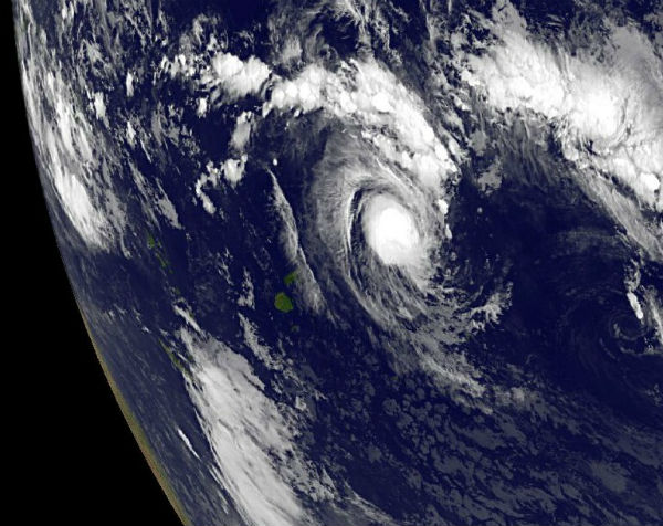
 TS Evan seen by MTSAT IR visible spectar
At 15:00 UTC on December 12, Tropical Storm Evan had maximum sustained winds near 50 knots (57.5 mph/92.6 kph). The center of Evan was located near 13.9 south latitude and 173.2 west longitude, about 145 nautical miles (170 miles/268.5 km) west of Pago Pago, American Samoa. Pago Pago is the capital of American Samoa. Tropical-storm-force winds extended 45 nautical miles (51.7 miles/83.3 km) from the center.
Evan will remain on an eastward track for the next 24 hours under the influence of the low- to mid-level near-equatorial ridge and will continue to intensify as vertical wind shear remains low and sea surface temperatures remain high.
 Ewan forecast track (Credit: JTWC)
MODIS/Aqua satellite and NOAA’s GOES-15 satellite both captured imagery of the newborn storm’s cloud cover.
The Atmospheric Infrared Sounder (AIRS) instrument aboard NASA’s Aqua satellite captured an infrared image of newborn Tropical Storm Evan over American Samoa on December 12, 2012 at 12:47 UTC. The strongest thunderstorms with cloud top temperatures exceeding -63F (-52C) appeared around the center of circulation and in a band of thunderstorms north and east of the center. Cloud top temperatures that cold indicate the highest, strongest storms with the heaviest rainfall within the tropical cyclone.
 The AIRS instrument aboard NASA’s Aqua satellite captured an infrared image of newborn Tropical Storm Evan over American Samoa on Dec. 12, 2012 at 12:47 UTC (7:47 a.m. EST). The strongest thunderstorms (purple) appear around the center of circulation and in a band of thunderstorms north and east of the center.
(Credit: NASA/JPL, Ed Olsen)
For more updated forecasts, go here.
Satellite Animations
- Storm-Centered Infrared (MTSAT; NOAA/SSD)
- Storm-Centered Infrared (Aviation Color Enhancement) (MTSAT; NOAA/SSD)
- Storm-Centered Water Vapor (MTSAT; NOAA/SSD)
- Storm-Centered Visible (MTSAT; NOAA/SSD)
- Storm-Centered Visible (Colorized) (MTSAT; NOAA/SSD)
- Southeast Pacific Infrared (GOES 11; NOAA)
- Southeast Pacific Enhanced Infrared (GOES 11; NOAA)
- Southeast Pacific Water Vapor (GOES 11; NOAA)

[…] Tropical Cyclone Evan formed in South Pacific – Trouble for American Samoa and Fiji. Share this:TwitterFacebookLinkedInTumblrMoreEmailPrintGoogle +1DiggRedditPinterestStumbleUponLike this:LikeBe the first to like this. […]