
Miriam became major hurricane – begins to weaken
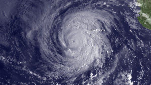
Image credit: TW
Hurricane Miriam has continued to rapidly strengthen yesterday and forecasts show a deeper and more robust cyclone in the next few days as the storm tracks toward Baja California. Miriam has weakened over the last several hours. The eye has become overcast and cloud tops have warmed near the center recently.
A gradual weakening is forecasted for next 24 to 36 hours as southwesterly shear, associated with a trough to the north-northwest of Miriam, increases a little. Miriam continues moving northwestward but at a slightly slower forward speed.

According to latest public advisory by US National Hurricane Center at 03:00 UTC on September 25, the center of Hurricane Miriam was located near latitude 18.5 north and longitude 113.9 west. Miriam is moving toward the northwest near 8 mph (13 km/h). A gradual turn to the north with a decrease in forward speed is expected during the next couple of days.
Maximum sustained winds have decreased to near 105 mph (165 km/h) with higher gusts. Miriam is a category two hurricane on the Saffir-Simpson hurricane wind scale. Slow weakening is expected during the next 48 hours. Hurricane force winds extend outward up to 35 miles (55 km) from the center and tropical storm force winds extend outward up to 125 miles (205 km). The estimated minimum central pressure is 968 mB.

Swells generated by Miriam will affect the south and west coasts of the southern Baja Peninsula during the next couple of days. These swells are likely to cause life-threatening surf and rip current conditions.

Satellite Animations
- Storm-Centered Infrared (GOES 15; NOAA/SSD)
- Storm-Centered Infrared (Aviation Color Enhancement) (GOES 15; NOAA/SSD)
- Storm-Centered Water Vapor (GOES 15; NOAA/SSD)
- Storm-Centered Visible (GOES 15; NOAA/SSD)
- Storm-Centered Visible (Colorized) (GOES 15; NOAA/SSD)
- East Pacific Infrared (GOES 15; NOAA/SSD)
- East Pacific (Aviation Color Enhancement) (GOES 15; NOAA/SSD)
- East Pacific Water Vapor (GOES 15; NOAA/SSD)
- East Pacific Visible (GOES 15; NOAA/SSD)
- East Pacific Visible (Colorized) (GOES 15; NOAA/SSD)
Commenting rules and guidelines
We value the thoughts and opinions of our readers and welcome healthy discussions on our website. In order to maintain a respectful and positive community, we ask that all commenters follow these rules.