
Massive earthquake magnitude 7.3 struck offshore El Salvador
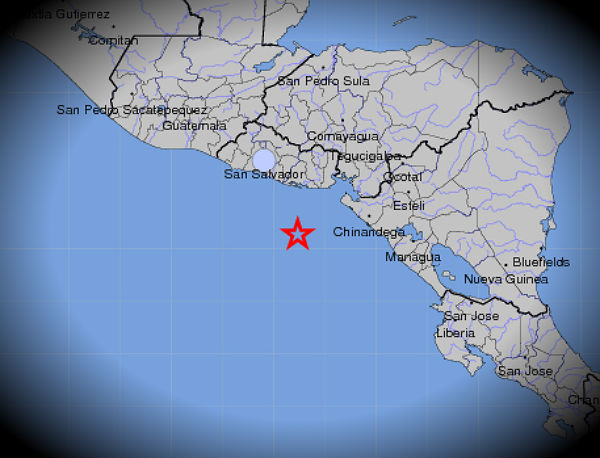
Image credit: TW
Massive M7.3 earthquake struck offshore El Salvador on August 27, 2012 at 04:37:23 UTC. The epicenter was located 118 km (74 miles) S from Usulután, 138 km (86 miles) SSW from San Miguel and 169 km (105 miles) SSE from capital San Salvador (12.279°N, 88.530°W). The depth of epicenter was 52.9 km (32.9 miles).
USGS reports a M7.4 at depth of 53 km, Geofon reports a M6.6 M7.1 at depth of 10 km and EMSC a M5.2 M7.3 at depth of 14 km.
USGS first reported magnitude 7.4 then later downgraded to 7.3. Biggest difference after evaluation was depth where they changed it from 52.9 km to 20.3 km (12.6 miles).
At 05:01 UTC aftershock with recorded magnitude of 4.6 and depth of 19.9 km was reported by USGS. At 05:38 UTC another strong aftershock with magnitude 5.4 was recorded. Depth was 57.8 km (35.9 miles).

")

Pacific Tsunami Warning Center issued a tsunami warning for Costa Rica, Nicaragua, El Salvador, Honduras, Guatemala, Panama and Mexico. They stated that it is not known that a tsunami was generated, however, an earthquake of this size has the potential to generate a destructive tsunami that can strike coastlines in the region near the epicenter within minutes to hours. NOAA West Coast and Alaska Tsunami Warning Center didn’t issue any warning.

TSUNAMI LOCATION FORECAST POINT COORDINATES ARRIVAL TIME
——————————– ———— ————
COSTA RICA CABO_SAN_ELENA 10.9N 274.0E 0526Z 27 AUG
PUERTO_QUEPOS 9.4N 275.8E 0553Z 27 AUG
CABO_MATAPALO 8.4N 276.7E 0555Z 27 AUG
NICARAGUA CORINTO 12.5N 272.8E 0532Z 27 AUG
PUERTO_SANDINO 12.2N 273.2E 0539Z 27 AUG
SAN_JUAN_DL_SUR 11.2N 274.1E 0551Z 27 AUG
EL SALVADOR ACAJUTLA 13.6N 270.2E 0543Z 27 AUG
HONDURAS AMAPALA 13.2N 272.4E 0556Z 27 AUG
GUATEMALA SIPICATE 13.9N 268.8E 0559Z 27 AUG
PANAMA PUNTA_BURICA 8.0N 277.1E 0605Z 27 AUG
PUNTA_MALA 7.5N 280.0E 0652Z 27 AUG
BALBOA_HTS. 9.0N 280.4E 0912Z 27 AUG
MEXICO PUERTO_MADERO 14.8N 267.5E 0606Z 27 AUG
Buoy Station 43413 – 360 NM South-Southwest of Acapulco, Mexico is in tsunami mode.
Epicenter location in Google Maps
")
[…] https://watchers.news/2012/08/27/magnitude-7-4-struck-offshore-el-salvador/ […]
[…] 7.4 Quake El Salvador http://www.youtube.com/watch?v=-BrCVGDmkFA&list=UUHE92x768p8h-fMrqhsnE1Q&index=0&feature=plcp http://maps.google.com/maps?f=q&hl=en&q=OFFSHORE%20EL%[email protected],-89.25&z=8&t=h&view=map&ie=UTF8&oe=UTF8 http://earthquake-report.com/2012/08/27/major-earthquakes-list-august-27-2012/ http://quakes.globalincidentmap.com/map_detail.php?id=217682 http://hisz.rsoe.hu/alertmap/site/index.php?pageid=seism_index&rid=268236 https://watchers.news/2012/08/27/magnitude-7-4-struck-offshore-el-salvador/ […]