
Active volcanoes in the world: August 15 – August 21, 2012
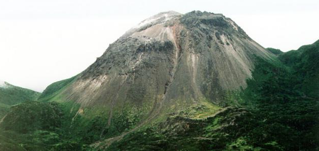
Image credit: Grozny Group - Photo by A. Korablev, 1993 (Institute of Marine Geology and Geophysics, Yuzhno-Sakhalin)
New unrest has been noticed around 5 volcanoes, ongoing activity was reported for 12 volcanoes. This report covers active volcanoes in the world recorded from August 15 – August 21, 2012 based on Smithsonian/USGS criteria.
The Weekly Volcanic Activity Report is a cooperative project between the Smithsonian’s Global Volcanism Program and the US Geological Survey’s Volcano Hazards Program. Updated by 2300 UTC every Wednesday, notices of volcanic activity posted on these pages are preliminary and subject to change as events are studied in more detail. This is not a comprehensive list of all of Earth’s volcanoes erupting during the week, but rather a summary of activity at volcanoes that meet criteria discussed in detail in the “Criteria and Disclaimers” section. Carefully reviewed, detailed reports on various volcanoes are published monthly in the Bulletin of the Global Volcanism Network.
New Activity/Unrest
GROZNY GROUP, Iturup Island
45.026°N, 147.922°E; summit elev. 1211 m
According to news reports, Ivan Grozny, one of two volcanoes comprising the Grozny Group, erupted on 16 August, after increased gas emissions from the NE flank were observed the day before. An ash plume rose 1.2 km and caused ashfall in Goryachiye Klyuchi (9 km W) and Kurilsk (25 km away). Residents reported a sulfur dioxide odor. By the afternoon ashfall had ceased and the odor subsided.
Geologic summary: The Grozny volcano group in central Iturup Island contains the complex volcanoes of Ivan Grozny and Tebenkov. The former has a 3-3.5 km diameter caldera that is open to the south, where the large, 1158-m-high andesitic Grozny extrusion dome (also known as Etorofu-Yake-yama) was emplaced. Several other lava domes of Holocene age were constructed to the NE; extrusion of these domes has constricted a former lake in the northern side of the caldera to an extremely sinuous shoreline. The forested andesitic Tebenkov volcano, also known as Odamoi-san, lies immediately to the NE of the Grozny dome complex. The large Machekh crater, which displays strong fumarolic activity, lies immediately south of Tebenkov. Historical eruptions, the first of which took place in 1968, have been restricted to Ivan Grozny.
SOTARA, Colombia
2.108°N, 76.592°W; summit elev. 4400+ m
According to INGEOMINAS, the Observatorio Vulcanológico and Sismológico de Popayán reported that during 8-14 August seismic activity at Sotará increased. The seismic network recorded 110 magnitude 0.2-1.6 events mainly located in an area 0.1-5 km NE of the peak, at depths of 2-6 km. Inflation was detected in the NE area, coincident with the zone of increased seismicity. Web-camera views showed no morphological changes. The Alert Level was raised to III (Yellow; “changes in the behavior of volcanic activity”), or the second lowest level.
Geologic summary: Volcán Sotará, also known as Cerro Azafatudo, is a little-known andesitic-dacitic stratovolcano located about 25 km SSE of Popayán city in southern Colombia, SW of Puracé volcano. Three calderas, 4.5, 2.5, and 1 km in diameter, are found on Sotará, giving the summit an irregular profile. No historicaleruptions are known from Sotará, however the volcano currently displays fumarolic and hot spring activity.
TONGARIRO, North Island (New Zealand)
39.13°S, 175.642°E; summit elev. 1978 m
GeoNet reported that seismic activity at Tongariro remained low during 14-16 August; weather conditions prevented observations of the craters. There were several reports of gas odors on 15 August, particularly from the Manawatu region (S). On 17 August GeoNet noted that although very minor amounts of ash were emitted in the first few days after the eruption, there had been no significant activity since 6 August. Seismic activity had returned to low levels after the eruption. The Alert Level was lowered to 1 (on a scale of 0-5) and the Aviation Colour Code remained at Yellow (second lowest on a four-color scale).
Geologic summary: Tongariro is a large andesitic volcanic massif, located immediately NE of Ruapehu volcano, that is composed of more than a dozen composite cones constructed over a period of 275,000 years. Vents along a NE-trending zone extending from Saddle Cone (below Ruapehu volcano) to Te Mari crater (including vents at the present-day location of Ngauruhoe) were active during a several hundred year long period around 10,000 years ago, producing the largest known eruptions at the Tongariro complex during the Holocene. The youngest cone of the complex, Ngauruhoe, has grown to become the highest peak of the massif since its birth about 2500 years ago. The symmetrical, steep-sided Ngauruhoe, along with its neighbor Ruapehu to the south, have been New Zealand’s most active volcanoes during historical time.
TUNGURAHUA, Ecuador
1.467°S, 78.442°W; summit elev. 5023 m
IG reported that on 15 August three small explosions from Tungurahua were detected along with continuous tremor. An ash plume rose 1 km above the crater and drifted W, producing ashfall in El Manzano (8 km SW) and Pillate (7 km W). Activity increased the next day, characterized by increased tremor, roaring sounds, and instances of vibrating windows. An ash plume again rose 1 km, drifted W, and produced ashfall in El Manzano and Pillate. On 17 August two long periods of tremor associated with emissions were detected; 10 explosions were also recorded. Periodic clear views of the crater showed continuous steam-and-ash plumes rising 1.5-3 km above the crater and drifting WNW. Ash fell in Pillate and Bilbao (8 km W). Activity significantly increased at 2100, and strong explosions were detected. Cloud cover prevented visual observations.
In the morning of 18 August, satellite images showed a 50-km-long plume drifting NW. A pyroclastic flow deposit on the NW flank was observed with a thermal camera. Steam-and-ash plumes rose 1.5 km and drifted WNW; ashfall was reported in Choglontús (SW), Pillate, and San Juan de Pillate (9 km W). Strong glow from the crater was observed at night, along with incandescent blocks rolling down the top of the cone. A pyroclastic flow descended the NE flank, and a lava flow on the N flank traveled 500 m.
Activity remained elevated on 19 and 20 August; continuous tremor indicating emissions was detected, along with nine explosions on 19 August and five on 20 August. Steam-and-ash plumes rose 1.5-2 km and drifted W and SW. Ash fell in Pillate, Igualata (20 km W), El Santuario, Hualpamba, Cevallos (23 km NW), Quero (20 km NW), Mocha (25 km WNW), Santa Anita, and Tisaleo (29 km NW). Roaring sounds were heard and explosions vibrated windows. Strombolian activity ejected incandescent blocks that landed a few hundred meters away. An overflight on 20 August revealed an 80-m-wide inner crater that contained lava. Blocks had accumulated at the headwaters of streams on the SW, W, and NW flanks. According to a news article, 110 families were evacuated.
On 21 August 16 large explosions were detected and again caused windows to vibrate. Strong “cannon shots” were heard in areas as far as Ambato (40 km NW), Riobamba (30 km S), and Milagro, though roaring noises decreased in intensity and duration compared to the previous few days. Ash plumes rose 1.5-5 km and drifted W, and a pyroclastic flow traveled 2.5 km down the NW flank.
Geologic summary: The steep-sided Tungurahua stratovolcano towers more than 3 km above its northern base. It sits ~140 km S of Quito, Ecuador’s capital city, and is one of Ecuador’s most active volcanoes. Historical eruptions have all originated from the summit crater. They have been accompanied by strong explosions and sometimes by pyroclastic flows and lava flows that reached populated areas at the volcano’s base. The last major eruption took place from 1916 to 1918, although minor activity continued until 1925. The latest eruption began in October 1999 and prompted temporary evacuation of the town of Baños on the N side of the volcano.
WHITE ISLAND, New Zealand
37.52°S, 177.18°E; summit elev. 321 m
On 17 August GeoNet Data Centre reported that that little to no ash was visible in the plume rising from White Island during the previous week. They also noted that seismicity was low and sulfur dioxide flux was at normal levels. The Alert Level was lowered to 1 (on a scale of 0-5), and the Aviation Colour Code remained at Yellow (second lowest on a four-color scale).
Geologic summary: The uninhabited 2 x 2.4 km White Island, one of New Zealand’s most active volcanoes, is the emergent summit of a 16 x 18 km submarine volcano in the Bay of Plenty about 50 km offshore of North Island. The 321-m-high island consists of two overlapping stratovolcanoes; the summit crater appears to be breached to the SE because the shoreline corresponds to the level of several notches in the SE crater wall. Throughout the short historical period beginning in 1826 the volcano has had long periods of continuous hydrothermal activity and steam release, punctuated by small-to-medium eruptions. Its activity also forms a prominent part of Maori legends. The most recent eruptive episode, which began on 7 March 2000, included the largest eruption at White Island in the past 20 years on 27 July.
Ongoing Activity
BATU TARA, Komba Island (Indonesia)
7.792°S, 123.579°E; summit elev. 748 m
Based on analyses of satellite imagery, the Darwin Volcanic Ash Advisory Centre (VAAC) reported that during 15-21 August ash plumes from Batu Tara rose to an altitude of 2.1 km (7,000 ft) a.s.l. and drifted 35-95 km W, NW, and NNW.
Geologic summary: The small isolated island of Batu Tara in the Flores Sea about 50 km north of Lembata (formerly Lomblen) Island contains a scarp on the eastern side similar to the Sciara del Fuoco of Italy’s Stromboli volcano. Vegetation covers the flanks of Batu Tara to within 50 m of the 748-m-high summit. Batu Tara lies north of the main volcanic arc and is noted for its potassic leucite-bearing basanitic and tephritic rocks. The first historical eruption from Batu Tara, during 1847-52, produced explosions and a lava flow.
CLEVELAND, Chuginadak Island
52.825°N, 169.944°W; summit elev. 1730 m
AVO reported that nothing unusual was observed at Cleveland in cloudy to partly cloudy satellite images during 15-16, 18, and 20-21 August. A small explosion was detected on 17 August by seismic and infrasound instruments on neighboring volcanoes. No evidence of an ash cloud was visible in satellite images following the event. Another small explosion on 19 August produced a low-level ash cloud, observed in satellite imagery, that drifted SE. Retrospective analysis of ground-coupled airwaves in seismic data further confirmed the explosion. The Volcano Alert Level remained at Watch and the Aviation Color Code remained at Orange.
Geologic summary: Symmetrical Mount Cleveland stratovolcano is situated at the western end of the uninhabited dumbbell-shaped Chuginadak Island in the east-central Aleutians. The 1,730-m-high stratovolcano is the highest of the Islands of Four Mountains group and is one of the most active in the Aleutians. Numerous large lava flows descend its flanks. It is possible that some 18th to 19th century eruptions attributed to Carlisle (a volcano located across the Carlisle Pass Strait to the NW) should be ascribed to Cleveland. In 1944 Cleveland produced the only known fatality from an Aleutian eruption. Recent eruptions from Mt. Cleveland have been characterized by short-lived explosive ash emissions, at times accompanied by lava fountaining and lava flows down the flanks.
ETNA, Sicily (Italy)
37.734°N, 15.004°E; summit elev. 3330 m
Sezione di Catania – Osservatorio Etneo reported that a new phase of activity at Etna’s Bocca Nuova summit crater started on 2 July, was virtually continuous for three weeks until 24 July, then rapidly decreased. During the first 10 days explosions were separated by quiet intervals lasting several minutes, then later became more continuous. During periods of the strongest activity, some lava bombs were ejected beyond the crater rim, landing on a gently sloping area E of the crater. Lava was emitted during 4-24 July from vents on the flanks of the pyroclastic cone that had begun to grow around the explosive vent. Rarely, lava was emitted from the main explosive vent. The lava progressively covered the crater floor next to the pyroclastic cone, which had grown 30-40 m, before the activity ceased on 24 July. Frequent ash emissions observed the next day were mostly due to explosions, and possibly from minor collapses of the summit area of the new cone. Concurrent with the decrease in eruptive activity, volcanic tremor amplitude dropped to background levels.
Episodic activity occurred during 26 July-11 August. At daybreak on 26 July, strong incandescence marked the onset of the first episode of activity within Bocca Nuova, which had the same characteristics as the previous activity; frequent Strombolian explosions were accompanied by lava flow emissions from a vent located on the W flank of the cone. The next day, the lava had almost completely filled the central subsidence pit on the floor of Bocca Nuova, and the cone had grown in height. The activity then decreased, and essentially ceased by the evening. There were intermittent ash emissions on 28 July, and volcanic tremor amplitude decreased to background levels.
The second episode, during 29 July-1 August, was characterized by small Strombolian explosions and lavaemission from a vent located on the S flank of the pyroclastic cone. Volcanic tremor amplitude showed strong oscillations, but never reached the same peak levels associated with the 26-27 July episode. Volcanic tremor amplitude dropped sharply on 1 August, marking the cessation of the activity; a few ash emissions were observed the next day.
The third episode began on 3 August with a rapid increase in the volcanic tremor amplitude and strong incandescence from Bocca Nuova, signaling the beginning of Strombolian activity and lava emissions onto the crater floor. Activity ceased the next day, and was followed by weak residual activity within Bocca Nuova, which generated small ash clouds. The fourth episode began on 6 August and ended the next day, and showed essentially the same characteristics as the previous episode.
The fifth episode began on 10 August and was again marked by a rapid increase in volcanic tremor amplitude; at nighl, bright glow illuminated the gas plume rising from the crater, which was visible up to tens of kilometers away. Some of the explosions ejected incandescent pyroclastic material well above the crater rim. The activity started to decrease just after midnight and then ended on 11 August. Subsequently, ash emissions resumed, which were particularly frequent on 13 August, and which produced small, brownish-gray clouds of fine-grained tephra. Some of the ash emissions later that evening were accompanied by ejected incandescent material; volcanic tremor amplitude, however, remained at background levels.
Geologic summary: Mount Etna, towering above Catania, Sicily’s second largest city, has one of the world’s longest documented records of historical volcanism, dating back to 1500 BC. Historical lava flows cover much of the surface of this massive basaltic stratovolcano, the highest and most voluminous in Italy. Two styles of eruptive activity typically occur at Etna. Persistent explosive eruptions, sometimes with minor lava emissions, take place from one or more of the three prominent summit craters, the Central Crater, NE Crater, and SE Crater. Flank eruptions, typically with higher effusion rates, occur less frequently and originate from fissures that open progressively downward from near the summit. A period of more intense intermittent explosive eruptions from Etna’s summit craters began in 1995. The active volcano is monitored by the Instituto Nazionale di Geofisica e Volcanologia (INGV) in Catania.
FUEGO, Guatemala
14.473°N, 90.880°W; summit elev. 3763 m
INSIVUMEH reported that during 15-16 and 18-21 August lava flows from Fuego traveled 250-500 m down the Taniluyá drainage (SW), generating block avalanches that reached vegetated areas. On 17 August 20-m-wide lahars traveled SE down the Las Lajas and El Júte drainages, carrying blocks 1.5 m in diameter. Steam rose from the deposits in Las Lajas. Explosions were heard during 18-29 August but weather conditions prevented observations. Explosions during 19-21 August produced ash plumes that rose 100-300 m above the crater and drifted N, NW, W, and SW. Incandescent material was ejected 40-100 m above the crater at night. In a special report issued on 21 August, INSIVUMEH stated that seismicity had increased, along with degassing and rumbling sounds. Incandescent material was ejected 150 m above the crater, and lava flows traveled 500 m down the El Júte and Taniluyá drainages, generating block avalanches that reached vegetated areas.
Geologic summary: Volcán Fuego, one of Central America’s most active volcanoes, is one of three large stratovolcanoes overlooking Guatemala’s former capital, Antigua. The scarp of an older edifice, Meseta, lies between 3,763-m-high Fuego and its twin volcano to the N, Acatenango. Construction of Meseta volcano continued until the late Pleistocene or early Holocene, after which growth of the modern Fuego volcano continued the southward migration of volcanism that began at Acatenango. Frequent vigorous historical eruptions have been recorded at Fuego since the onset of the Spanish era in 1524, and have produced major ashfalls, along with occasional pyroclastic flows and lava flows. The last major explosive eruption from Fuego took place in 1974, producing spectacular pyroclastic flows visible from Antigua.
GALERAS, Colombia
1.22°N, 77.37°W; summit elev. 4276 m
INGEOMINAS reported that both earthquake occurrence and magnitude were low at Galeras during 14-21 August. Sulfur dioxide emissions fluctuated, but remained at moderate levels. An ash plume rose from the crater on 16 August. White plumes were observed during 16 and 18-21 August. The Alert Level remained at III (Yellow; “changes in the behavior of volcanic activity”).
Geologic summary: Galeras, a stratovolcano with a large breached caldera located immediately W of the city of Pasto, is one of Colombia’s most frequently active volcanoes. The dominantly andesitic Galeras volcanic complex has been active for more than 1 million years, and two major caldera collapse eruptions took place during the late Pleistocene. Longterm extensive hydrothermal alteration has affected the volcano. This has contributed to large-scale edifice collapse that has occurred on at least three occasions, producing debris avalanches that swept to the W and left a large horseshoe-shaped caldera inside which the modern cone has been constructed. Major explosive eruptions since the mid Holocene have produced widespread tephra deposits and pyroclastic flows that swept all but the southern flanks. A central cone slightly lower than the caldera rim has been the site of numerous small-to-moderate historical eruptions since the time of the Spanish conquistadors.
KARYMSKY, Eastern Kamchatka (Russia)
54.05°N, 159.45°E; summit elev. 1536 m
KVERT reported moderate seismic activity from Karymsky during 10-20 August. Satellite imagery showed a weak thermal anomaly on the volcano during 10-13, 15, and 18-20 August. The Aviation Color Code remained at Orange.
Geologic summary: Karymsky, the most active volcano of Kamchatka’s eastern volcanic zone, is a symmetrical stratovolcano constructed within a 5-km-wide caldera that formed about 7,600-7,700 radiocarbon years ago. Construction of the Karymsky stratovolcano began about 2,000 years later. The latest eruptive period began about 500 years ago, following a 2,300-year quiescence. Much of the cone is mantled by lava flows less than 200 years old. Historical eruptions have been Vulcanian or Vulcanian-Strombolian with moderate explosive activity and occasional lava flows from the summit crater. Most seismicity preceding Karymsky eruptions has originated beneath Akademia Nauk caldera, which is located immediately S of Karymsky volcano and erupted simultaneously with Karymsky in 1996.
KILAUEA, Hawaii (USA)
19.421°N, 155.287°W; summit elev. 1222 m
During 15-21 August HVO reported that the circulating lava lake periodically rose and fell in the deep pit within Kilauea’s Halema’uma’u Crater. Occasional measurements indicated that the gas plume from the vent continued to deposit variable amounts of spatter and Pele’s hair onto nearby areas. There were no significant geologic changes in Pu’u ‘O’o Crater; the glowing vent at the base of the SE flank continued to glow brightly, and incandescence emanated from a lava lake in a pit on the NE part of the crater floor. A small, new pit crater opened on the S crater floor on 17 August. Lava flows were active on the pali and the coastal plain. The active lava-flow front was about 2 km from the ocean on 18 August.
Geologic summary: Kilauea, one of five coalescing volcanoes that comprise the island of Hawaii, is one of the world’s most active volcanoes. Eruptions at Kilauea originate primarily from the summit caldera or along one of the lengthy E and SW rift zones that extend from the caldera to the sea. About 90% of the surface of Kilauea is formed of lava flows less than about 1,100 years old; 70% of the volcano’s surface is younger than 600 years. A long-term eruption from the East rift zone that began in 1983 has produced lava flows covering more than 100 sq km, destroying nearly 200 houses and adding new coastline to the island.
NEVADO DEL RUIZ, Colombia
4.895°N, 75.322°W; summit elev. 5321 m
According to INGEOMINAS, the Observatorio Vulcanológico and Sismológico de Manizales reported that during 15-16 and 18-21 August variations in volcanic tremor amplitude were detected at Nevado del Ruiz, possibly associated with continuing gas and ash emissions. Earthquakes indicative of fracturing rock were located SE at depths of 1.5-4 km, with magnitudes less than 1. One event on 18 August was a M 2, located 1.17 km SW of Arenas Crater at a depth of 3.6 km. Web cameras showed gas-and-ash plumes rising 400 m and drifting W and NW during 15-16 August. A gas plume rose 400 m and drifted NW on 19 August. During 20-21 August field measurements and analysis of satellite imagery showed a significant amount of sulfur dioxide in the atmosphere. The Alert Level remained at II (Orange; “eruption likely within days or weeks”).
Geologic summary: Nevado del Ruiz is a broad, glacier-covered volcano in central Colombia that covers >200 sq km. Three major edifices, composed of andesitic and dacitic lavas and andesitic pyroclastics, have been constructed since the beginning of the Pleistocene. The modern cone consists of a broad cluster of lava domes built within the summit caldera of an older Ruiz volcano. The 1-km-wide, 240-m-deep Arenas crater occupies the summit. Steep headwalls of massive landslides cut the flanks of Nevado del Ruiz. Melting of its summit icecap during historical eruptions, which date back to the 16th century, has resulted in devastating lahars, including one in 1985 that was South America’s deadliest eruption.
POPOCATEPETL, México
19.023°N, 98.622°W; summit elev. 5426 m
CENAPRED reported that during 15-21 August seismicity at Popocatépetl indicated continuing gas-and-steam emissions that may have contained ash; cloud cover often prevented visual observations of the volcano. Incandescence from the crater was observed at night. A gas-and-ash plume rose from the crater on 15 August, and steam-and-gas plumes rose as high as 1 km and drifted NW the next day. On 17 August seismicity significantly increased. Incandescent tephra ejected from the crater fell onto the flanks and rolled 800 m. On 18 August an ash plume rose 2 km above the crater and drifted E. Ejected incandescent tephra fell onto the SE flank. A small ash emission and ejected incandescent tephra were observed on 19 August. The next day a steam-and-gas plume rose 900 m and drifted NNW. The Alert Level remained at Yellow, Phase Three.
Geologic summary: Popocatépetl, whose name is the Aztec word for smoking mountain, towers to 5,426 m 70 km SE of Mexico City and is North America’s second-highest volcano. Frequent historical eruptions have been recorded since the beginning of the Spanish colonial era. A small eruption on 21 December 1994 ended five decades of quiescence. Since 1996 small lava domes have incrementally been constructed within the summit crater and destroyed by explosive eruptions. Intermittent small-to-moderate gas-and-ash eruptions have continued, occasionally producing ashfall in neighboring towns and villages.
SAKURA-JIMA, Kyushu
31.585°N, 130.657°E; summit elev. 1117 m
JMA reported that during 17-20 August explosions from Sakura-jima’s Showa Crater ejected tephra as far as 1,300 m from the crater. Based on information from JMA, the Tokyo VAAC reported that explosions during 17-21 August produced plumes that rose to altitudes of 2.4-3.4 km (8,000-11,000 ft) a.s.l. and drifted N and NW. Pilots observed ash plumes during 18-20 August that rose to altitudes of 2.1-4.3 km (7,000-14,000 ft) a.s.l. and drifted S, SW, and W.
According to a news report, the total amount of ash emitted from Sakura-jima from January to July was more than two times larger than all of 2011, when a record number of eruptions had occurred.
Geologic summary: Sakura-jima, one of Japan’s most active volcanoes, is a post-caldera cone of the Aira caldera at the northern half of Kagoshima Bay. Eruption of the voluminous Ito pyroclastic flow was associated with the formation of the 17 x 23-km-wide Aira caldera about 22,000 years ago. The construction of Sakura-jima began about 13,000 years ago and built an island that was finally joined to the Osumi Peninsula during the major explosive and effusive eruption of 1914. Activity at the Kita-dake summit cone ended about 4,850 years ago, after which eruptions took place at Minami-dake. Frequent historical eruptions, recorded since the 8th century, have deposited ash on Kagoshima, one of Kyushu’s largest cities, located across Kagoshima Bay only 8 km from the summit. The largest historical eruption took place during 1471-76.
SANTA MARIA, Guatemala
14.756°N, 91.552°W; summit elev. 3772 m
INSIVUMEH reported that during 15-16 and 18-20 August explosions from Santa María’s Santiaguito lava-domecomplex produced ash plumes that rose 400-900 m above Caliente dome and drifted 10 km W and NW. Block avalanches originated from the fronts of multiple active flows. White gas plumes rose 200 m and drifted WNW and SW. During 18-20 August ashfall was reported in Monte Claro (S), El Rosario (45 km SW), Palajunoj (S), and surrounding areas. Sounds resembling avalanches were reported on 21 August, however weather conditions prevented visual observations.
Geologic summary: Symmetrical, forest-covered Santa María volcano is one of a chain of large stratovolcanoesthat rises dramatically above the Pacific coastal plain of Guatemala. The stratovolcano has a sharp-topped, conical profile that is cut on the SW flank by a large, 1-km-wide crater, which formed during a catastrophic eruption in 1902 and extends from just below the summit to the lower flank. The renowned Plinian eruption of 1902 followed a long repose period and devastated much of SW Guatemala. The large dacitic Santiaguito lava-dome complex has been growing at the base of the 1902 crater since 1922. Compound dome growth at Santiaguito has occurred episodically from four westward-younging vents, accompanied by almost continuous minor explosions and periodic lava extrusion, larger explosions, pyroclastic flows, and lahars.
SHIVELUCH, Central Kamchatka (Russia)
56.653°N, 161.360°E; summit elev. 3283 m
KVERT reported that during 10-18 August weak seismic activity was detected at Shiveluch. Observers noted gas-and-steam activity during 15-17 August; weather conditions prevented observations of the volcano on the other days. Satellite imagery showed a thermal anomaly on the lava dome during 10, 12-13, and 18-19 August. Seismic activity increased to moderate levels and hot avalanches were observed during 19-20 August. TheAviation Color Code remained at Orange.
Geologic summary: The high, isolated massif of Shiveluch volcano (also spelled Sheveluch) rises above the lowlands NNE of the Kliuchevskaya volcano group and forms one of Kamchatka’s largest and most active volcanoes. The currently active Molodoy Shiveluch lava-dome complex was constructed during the Holocenewithin a large breached caldera formed by collapse of the massive late-Pleistocene Strary Shiveluch volcano. At least 60 large eruptions of Shiveluch have occurred during the Holocene, making it the most vigorous andesiticvolcano of the Kuril-Kamchatka arc. Frequent collapses of lava-dome complexes, most recently in 1964, have produced large debris avalanches whose deposits cover much of the floor of the breached caldera. Intermittent explosive eruptions began in the 1990s from a new lava dome that began growing in 1980. The largest historical eruptions from Shiveluch occurred in 1854 and 1964.
Source: Global Volcanism Program
I'm a dedicated researcher, journalist, and editor at The Watchers. With over 20 years of experience in the media industry, I specialize in hard science news, focusing on extreme weather, seismic and volcanic activity, space weather, and astronomy, including near-Earth objects and planetary defense strategies. You can reach me at teo /at/ watchers.news.
Time to take a break and recalibrate the senses.
Do you know where you gonna go ? Will it be New York City, Mexico, Nashville, Tennessee, Yukon Territory or San Diego ?
https://www.youtube.com/watch?v=IjGHwGkFIFw