
Hundreds of fires covering central Africa (satellite view)
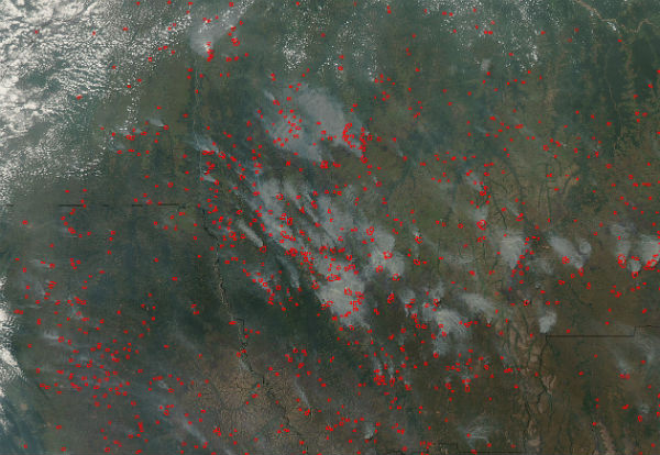
Image credit: TW
Hundreds of fires covered central Africa in mid-June, 2012, as the annual fire season heated up across the region. Multiple red hotspots, which indicate areas of increased temperatures, are heavily sprinkled across Angola (south), the Democratic Republic of the Congo (northeast), and Zambia (southeast). Thick gray smoke rises from most of the hotspots, and in some areas, especially in the Democratic Republic of the Congo, strong winds drive the smoke to the northwest. A heavy, smoke-filled haze blankets the entire region.

The Moderate Resolution Imaging Spectroradiometer (MODIS) aboard the Aqua satellite captured this true-color image on June 15, 2012 at 12:50 UTC (1:20 p.m. West African Time).
- (Credit: Jeff Schmaltz MODIS Land Rapid Response Team, NASA GSFC)
The fire season is an annual event in this region, as residents burn scrub, brush and woody savanna to open land for farming, for hunting and to drive away pests. Fire is also used on agricultural land to renew pasture grown and remove crop residue. Although lightning can also ignite fires in this region, it is highly likely that most of these fires are agricultural in origin. (MODIS)
I'm glad I finally discovered what those 'rings of fire' I saw from the night sky when flying from Johannesburg to Dubai in June 2012. It looked like the rings of volcanoes that you would see in Hawaii.
Wow. This is unbelievable. I’m praying for all these people right now…
🙂 Diane
Russia declares similar outbreak of fires captured by NASA’s Terra satellite using MODIS or Moderate Resolution Imaging Spectroradiometer instruments.
Interesting that many of the fires are caused by dry conditions, agricultural burning, lightning and human involvement according to the article. The fires in Colorado piqued my interest when slurry planes were called off for 1.5 hours due to meteor showers in the area.
I wonder if the same applies to Africa and Russia when it comes to meteor showers? I get the whole slash and burn techniques used by locals to clear land, but some of the locations in Russia appear to be scattered further apart and extremely remote without coordinates to better assess population.
[…] Hundreds of fires covering central Africa (satellite view) […]