
Shallow earthquake magnitude 5.2 hit near the southeast coast of Australia
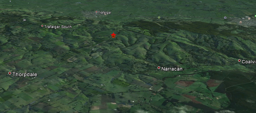
Image credit: Google Earth + USGS
Shallow earthquake with recorded magnitude of 5.2 hit near the southeast coast of Australia according to USGS. Epicenter was located 10 km (6 miles) SW of Moe, Australia (38.244°S, 146.194°E), 116 km (72 miles) from Melbourne city center. Recorded depth was 9.9 km (6.2 miles).
Geoscience Australia first reported 5.5 magnitude then downgraded to 5.3 with depth of 10km.
This is first earthquake in 2012 and so far the biggest earthquake in century for Victoria region. By many reports lasted between 30-40 seconds. A merely light top moderate shaking has been experienced by many people.
| Magnitude | 5.2 |
|---|---|
| Date-Time |
|
| Location | 38.244°S, 146.194°E |
| Depth | 9.9 km (6.2 miles) |
| Region | NEAR THE SOUTHEAST COAST OF AUSTRALIA |
| Distances | 10 km (6 miles) SW of Moe, Australia 18 km (11 miles) W of Morwell, Australia 30 km (18 miles) WSW of Traralgon, Australia 78 km (48 miles) WSW of Sale, Australia |
| Location Uncertainty | horizontal +/- 15.2 km (9.4 miles); depth +/- 2.9 km (1.8 miles) |
| Parameters | NST= 44, Nph= 49, Dmin=410.8 km, Rmss=1.12 sec, Gp= 68°, M-type=body wave magnitude (Mb), Version=5 |
| Source |
|
| Event ID | usb000ajek |

Historical seismicity – 2012

Historical seismicity – since 1900

I'm a dedicated researcher, journalist, and editor at The Watchers. With over 20 years of experience in the media industry, I specialize in hard science news, focusing on extreme weather, seismic and volcanic activity, space weather, and astronomy, including near-Earth objects and planetary defense strategies. You can reach me at teo /at/ watchers.news.
Commenting rules and guidelines
We value the thoughts and opinions of our readers and welcome healthy discussions on our website. In order to maintain a respectful and positive community, we ask that all commenters follow these rules.