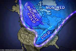
Brutally cold air mass forming up north of Northern America

The cold air will continue to expand toward the south and east Sunday night and Monday bringing some of the lowest temperatures so far from New Mexico and West Texas to the Great Lakes. The storm that brought snow to the Front Range of the Rockies and a section of the Great Plains Saturday will impact the Upper Midwest tonight and early Sunday according to AccuWeather forecast. The advance of the cold air will come with consequences.
Way up north an even colder air mass is forming. That blast will hit the Canadian Prairies later Tuesday and Wednesday forcing temperatures below zero. Some of that cold air will impact the United States later next week with the biggest push probably into the Plains and Midwest.

The Intermountain region and the western Great Plains were mighty cold today. In the Denver area, the temperature hovered around 20 degrees most of the morning and snow was coming down. Plus, a wind gusting over 20 miles per hour made it feel like it was zero to 5 below zero.
The greatest amounts will occur along a stretch from northern Iowa across southeastern Minnesota to the Upper Peninsula of Michigan. That storm will move into Ontario and Quebec Sunday in a much weakened state. Elsewhere, another snow system will be riding a second shot of cold air into Montana and Wyoming Sunday.
Snow amounts will be light at first but this will turn into a pretty decent snowstorm for southern Colorado, eastern New Mexico and West Texas Sunday night and Monday where accumulations could exceed 6 inches. Plus it’s going to be darn cold.

Commenting rules and guidelines
We value the thoughts and opinions of our readers and welcome healthy discussions on our website. In order to maintain a respectful and positive community, we ask that all commenters follow these rules.