
US all-time dew point record, extreme heat wave headed to the East
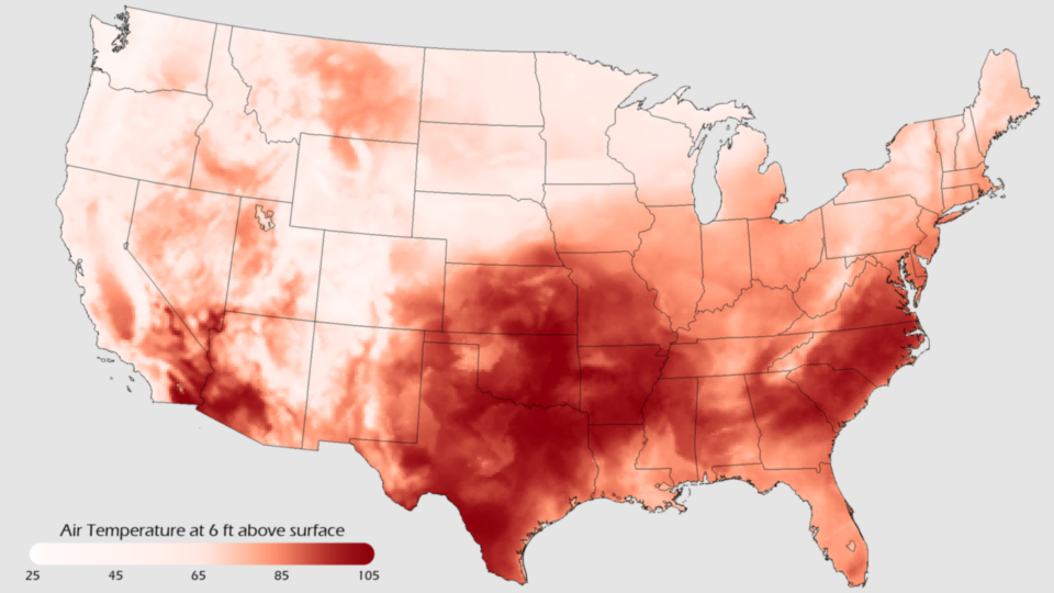
Image credit: TW
Amidst one of the worst heat waves of the year, the unbearably high humidity levels that accompanied the extreme heat set a record in the Twin Cities on Tuesday.
The dew point temperature, an indicator of how moist and uncomfortable the air feels, reached 82° on Tuesday afternoon at Minneapolis-St. Paul International Airport, breaking an all-time record for the city. Combined with an air temperature of 95° at 4:00 p.m. local time, soared to around 115°.

Dew points above 70 are considered very uncomfortable, and those above 80 are almost intolerable. Those intolerable dew points in the low 80s have been spread all across the Midwest the past few days.
In Newton, Iowa, temperatures in the high 90s and a dew point above 80° in Newton, Iowa, led to a RealFeel® temperature of close to 120° on Tuesday. Some areas even peaked out around 130°, though the accuracy of the measurements was in question.

Meteorologist Heather Buchman described the heat wave as ‘morphing the U.S. into an enormous sauna,’ and addes the “worst is on its way” to the East Coast by the end of the week.
The previous dew point record at Minneapolis-St. Paul International Airport was 81° from July 30, 1999. Daily record keeping at the airport began in 1945. (AccuWeather)

The extreme heat will shift slowly eastwards this week, peaking in Chicago today, Detroit and Pittsburgh on Thursday, and New York City and the mid-Atlantic states on Friday. The forecast high of 103° in Washington D.C. for Friday is just 3° below the hottest temperature ever recorded in the city, 106°. This will no doubt stimulate some predictable quotes on global warming. The heat will remain in place over the mid-Atlantic states through Sunday, then ease on Monday when a cold front is expected to pass through. Wunderground’s climate change blogger Dr. Ricky Rood has some good insights on the current heat wave in his latest post. (Wunderground)

What is The RealFeel Temperature?
The RealFeel Temperature is an index that describes what the temperature really feels like. It is a unique composite of the effects of temperature, wind, humidity, sunshine intensity, cloudiness, precipitation and elevation on the human body–everything that affects how warm or cold a person feels.
Temperature by itself gives only part of the picture. Other measures, like the Wind Chill or Heat Index, include temperature and only one additional element like wind speed or humidity and many are designed to measure effects on an inanimate object or an unclothed person. None of them tell what it really feels like to an appropriately dressed person. Only The RealFeel Temperature includes everything that affects how warm or cold a person feels.
For example, on a steamy July day without a breath of wind, with the noon sun beating down, the official temperature (which is measured in the shade) may be 92 degrees. But when you stand outside in the scorching sun, it may feel like 118 degrees. In contrast, when the official temperature is 92 degrees with a nice breeze blowing and low humidity, with bright sunshine but late in the day so the sun intensity is not as strong, it may feel like 86 degrees. (…)
Commenting rules and guidelines
We value the thoughts and opinions of our readers and welcome healthy discussions on our website. In order to maintain a respectful and positive community, we ask that all commenters follow these rules.