
Strange vortex forming over Atlantic

Image credit: TW
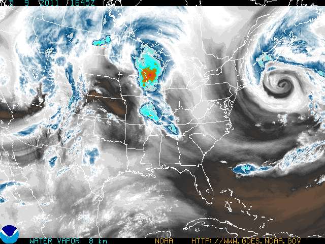
Strange vortex is forming over Atlantic at East Coast. Here are some preliminary data. Stay tuned for updates!
Update: Counterclockwise hurricane forming in Atlantic
East Conus Water Vapor Loop
Satellite loop 12 hours: East Coast

SYNOPSIS FOR LONG ISLAND WATERS AND NEW YORK HARBOR

LOW PRESSURE WILL CONTINUE TO MOVE SOUTH OF NOVA SCOTIA AND SLOWLY

DRIFT SOUTHEAST TOWARDS THE END OF THIS WEEK. HIGH PRESSURE WILL

GRADUALLY BUILD IN ALONG THE EASTERN SEABOARD FROM SOUTHEAST

CANADA BY MID TO LATE THIS WEEK.


MORICHES INLET NY TO MONTAUK POINT NY OUT 20 NM-

428 AM EDT MON MAY 9 2011


Real-Time Imagery and Data

Earlier reporting
Nothing on Watchers was published in the last 24 hours. These are older articles.
- CPC posts a slight risk of heavy rain from the Gulf Coast to the Northeast urban corridor November 25-29, and a moderate risk of West Coast wind and Sierra snow on November 25
- The storms drenching California this week are fed by a river in the sky, a band of water vapor that can carry up to 15 times the flow of the Mississippi River, and this winter’s near-record El Niño could keep aiming more of them at the West Coast
- Atmospheric river brings moderate risk of heavy rain, mountain snow and high winds to northern California and southwest Oregon on November 24-25
- 190 mm of rain and 131 km/h gusts hit New Zealand's South Island, flooding West Coast highways

jamie commented on The Watchers:
I go information about this vortex and it’s common. This isn’t a hurricane.
Vin commented on The Watchers:
Open ur eyes all u want just move ur butt away from this when it hits
jamie commented on The Watchers:
So what does all this means? Is this Hurrican formation going to hit the NORTH EAST? What category is this storm. How come main stream media isn’t reporting this formation.
Armelle commented on The Watchers:
Some shits about to go down too many strange changes are happened this year somethin big is about to happy and if most of us dont open are eyes alot of us are not gonna make it.