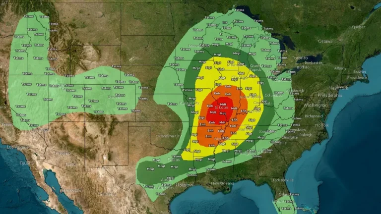
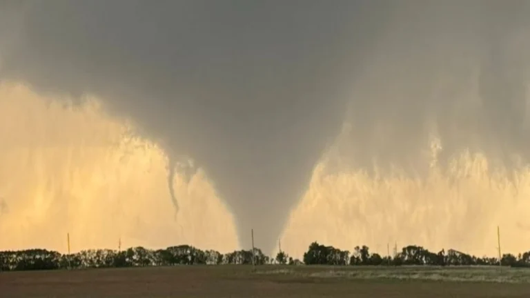
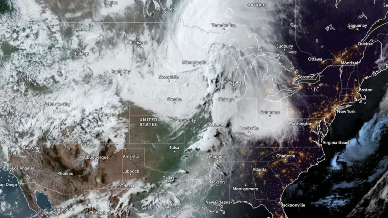
• Historic March blizzard buries parts of Michigan’s Upper Peninsula under up to 132 cm (52 inches) of snow

    A late-season blizzard affected northern Michigan between March 15 and 17, 2026, dropping up to 132.1 cm (52 inches) of snow in parts of the Upper Peninsula and breaking snowfall records at the National Weather Service office in Marquette. Governor Gretchen Whitmer declared a state of emergency on March 17 for seven counties in the Upper Peninsula and northern Lower Peninsula as heavy snow, ice, and strong winds disrupted travel and power service.

  • Atmospheric river forecast to stall over Washington, raising flood risk through March 20

    A stalled atmospheric river over the Pacific Northwest is forecast to deliver 127–254 mm (5–10 inches) of precipitation to parts of Washington between March 17 and 20, 2026. High freezing levels above 2 100 m (7 000 feet) will result in rainfall across most elevations, accelerating snowmelt and increasing the likelihood of riverine flooding.

  • Dust storm triggers multi-vehicle crash on U.S. 287 in northern Texas

    A multi-vehicle crash occurred on U.S. Highway 287 near Quanah in Hardeman County, northern Texas, on March 15, after strong winds generated blowing dust that rapidly reduced visibility and created dangerous driving conditions. Video footage recorded in the area shows dense dust moving across the highway as vehicles traveled through the corridor. Visibility deteriorated rapidly…

  • Morrill Fire becomes largest in Nebraska history as statewide fires top 243 000 ha (600 000 acres)

    A wildfire outbreak in western and central Nebraska has burned more than 243 000 ha (600 000 acres) since March 12, 2026, according to state officials, including the Morrill Fire, which Gov. Jim Pillen described as the largest wildfire in Nebraska history. One fatality has been confirmed as strong winds and critically dry vegetation fueled a rapid fire spread across the Nebraska Sandhills. The fires have also burned parts of Crescent Lake National Wildlife Refuge within the Sandhills, a region regarded as the world’s most intact temperate grassland.

  • Rare Moderate Risk (4/5) issued for Mid-Atlantic as severe thunderstorms raise threat of damaging winds and tornadoes

    A Moderate Risk (Level 4 of 5) for severe thunderstorms has been issued across parts of the Mid-Atlantic United States for Monday, March 16, 2026, as a powerful multi-hazard storm threatens over 100 million people across the U.S. Fast-moving storms capable of producing damaging winds and a few strong tornadoes are forecast to develop from the Carolinas into Virginia and Maryland during the afternoon and evening hours. A Moderate Risk is an unusually high severe weather category for the Mid-Atlantic and is not issued often for this region. The National Weather Service office serving the Washington, D.C. area described the setup as a “quite rare Day 2 Moderate Risk area” ahead of the event.

  • Snowstorm causes spinouts and closure of I-90 at Snoqualmie Pass, Washington

    Heavy snowfall caused multiple vehicle spinouts and crashes on I-90 at Snoqualmie Pass in Washington, forcing authorities to close the highway in both directions on March 13 and keep it closed overnight into March 14, 2026. Snoqualmie Pass received about 56 cm (22 inches) of new snow overnight, while the Summit at Snoqualmie reported about 107 cm (42 inches) over 48 hours during the storm.

  • Major winter storm brings blizzard conditions to Northern Plains and Great Lakes

    A major winter storm is affecting the Northern Plains and the western Great Lakes in the United States on March 15–16, bringing heavy snowfall, strong winds, and widespread blizzard conditions. Snowfall rates of up to 7.5 cm (3 inches) per hour and wind gusts of up to 95 km/h (60 mph) are forecast across parts of eastern South Dakota, Wisconsin, and Michigan as a strengthening low-pressure system moves toward southeastern Canada. Travel conditions are expected to become extremely dangerous across the affected region.

  • Red Flag Warnings issued for parts of Texas, New Mexico, Oklahoma and Colorado as critical fire weather spreads on March 15

    Strong winds and very dry air behind a powerful storm system are creating critical fire weather across parts of Texas, New Mexico, Oklahoma, and Colorado on March 15, 2026, prompting Red Flag Warnings across multiple forecast areas. Wind gusts may reach 105 km/h (65 mph), while relative humidity is forecast to fall as low as 6 to 15 percent in some areas, supporting rapid fire growth and spread.

  • Freeze Warnings and Watches issued across parts of Texas, Oklahoma, Arkansas, Louisiana, Mississippi, Alabama, Missouri, and Tennessee

    Freeze Warnings and Watches have been issued for parts of eight southern U.S. states as sub-freezing temperatures are forecast from March 16 into March 17, 2026. Temperatures could fall as low as −12°C (10°F) in the coldest parts of Arkansas, while many other areas are expected to bottom out in the −7°C to −2°C (19 to 28°F) range. Frost, freeze conditions, and gusty post-frontal winds may damage sensitive vegetation and, in the coldest areas, affect exposed outdoor plumbing.