
Seismic scans confirm asteroid origin of Silverpit Crater in North Sea
High-resolution seismic imaging and shocked mineral evidence confirm that Silverpit Crater beneath the North Sea was formed by an asteroid impact 43–46 million years ago, according to a study published in Nature Communications on September 20, 2025.

Transmitted-light photomicrograph. Credit: Multiple lines of evidence for a hypervelocity impact origin for the Silverpit Crater, Uisdean Nicholson et al.
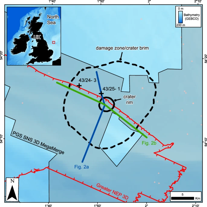
Silverpit Crater lies in the southern North Sea on the UK continental shelf, covered by roughly 700 m (2 300 feet) of sediments. The structure was first recognized in 2002 from partial 3D seismic data acquired for hydrocarbon exploration.
At that time, it was interpreted as a multi-ringed crater up to 20 km (12 miles) across, possibly dating to the Cretaceous–Paleogene boundary. Early images suggested a circular depression with concentric faults and an uplift beneath the floor, features consistent with impact craters but alternative explanations soon emerged.
Some geologists argued that the feature could be caused by subsurface salt withdrawal in the mobile Zechstein evaporite layer, which underlies the region while others proposed volcanic activity or hydrothermal venting linked to Paleogene dykes.
The debate came to a head in 2009 at the Geological Society of London, where a public vote strongly favored a non-impact origin. For more than a decade, Silverpit was treated as a geological curiosity rather than a confirmed impact crater.


Salt, chalk, and a controversial structure
The local geology made the question especially complex. The Silverpit Basin has undergone multiple episodes of rifting and uplift since the Paleozoic. At the site, Triassic and Jurassic carbonates and clastic rocks rest on mobile Zechstein salt, overlain by Cretaceous chalk and Paleogene mudstones.
Salt mobility in the subsurface has created many circular collapse features in the North Sea. This led to a widely cited hypothesis that Silverpit was simply a salt withdrawal structure. Other skeptics argued for volcanic venting, pointing to dykes elsewhere in the basin.
For years, the absence of shocked minerals, the diagnostic evidence of hypervelocity impact, meant the impact interpretation could not be confirmed.
Seismic imaging reveals the crater’s true form
A turning point came in 2022, when the Northern Endurance Partnership acquired high-resolution 3D seismic data during surveys for potential carbon storage sites. This dataset, with improved bandwidth and fault imaging, covered the entire Silverpit structure for the first time.
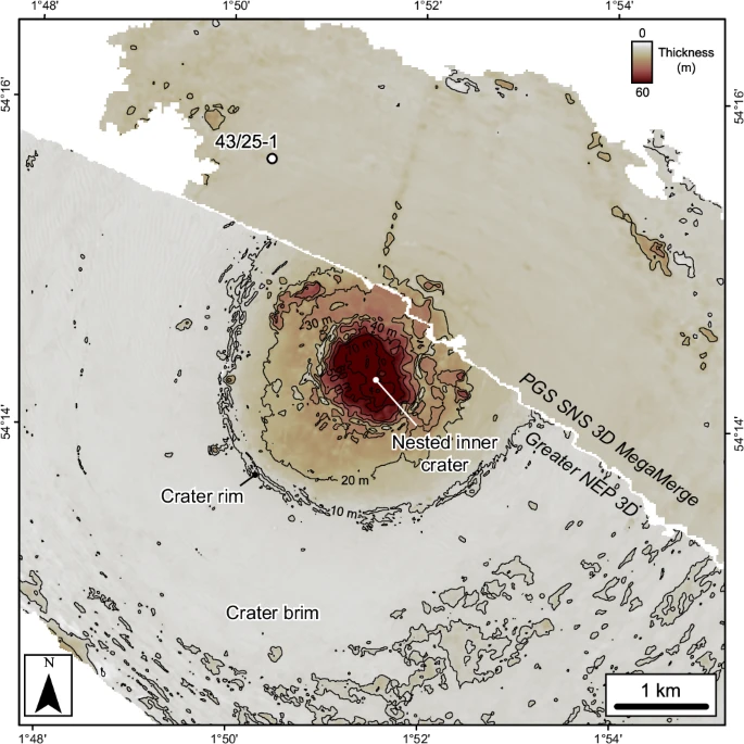
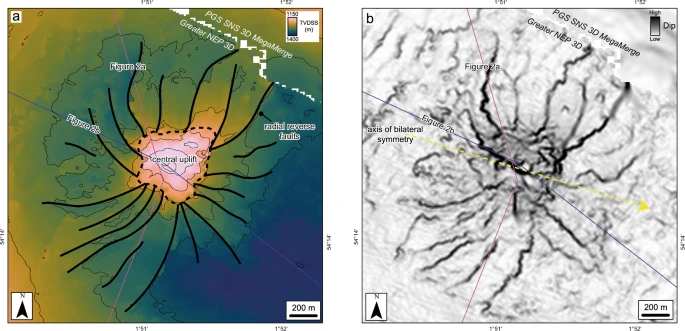
The results showed a 3.2 km (2 miles) wide crater with a central uplift, an annular moat, and a surrounding “brim” defined by concentric faults extending out to about 18 km (11 miles). The morphology, including uplift ratios and depth-to-diameter scaling, matched expectations for a complex marine impact crater.
Seismic attributes also revealed secondary craters, circular depressions 50–150 m across (164–492 feet) and up to 35 m (115 feet) deep, just beyond the crater rim. These are consistent with material ejected during impact and re-entering nearby. Secondary craters are common on the Moon and Mars but are rarely preserved on Earth, making Silverpit an exceptional case.
The data also disproved earlier claims that the central uplift was a seismic artifact. Full coverage demonstrated that the uplift and associated reverse faults are real geological structures, not processing effects.
Shocked quartz and feldspar confirm the impact
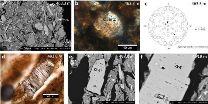
Independent confirmation came from an unexpected source, well cuttings drilled by British Gas in 1985, just northwest of Silverpit.
In sediments corresponding to the crater floor, researchers found two mineral grains, one quartz and one feldspar, containing planar deformation features. These microscopic lamellae form only under shock pressures of 10–13 GPa, conditions unique to asteroid impacts.
Biostratigraphic analysis of marine microfossils from the same depth placed the age of the crater between 43 and 46 million years ago, in the middle Eocene. This ruled out earlier Cretaceous interpretations.
The sample size is small, and only two shocked grains were identified. Critics may argue they could have been transported from another event. However, their stratigraphic context and association with the crater floor make a local origin most likely.


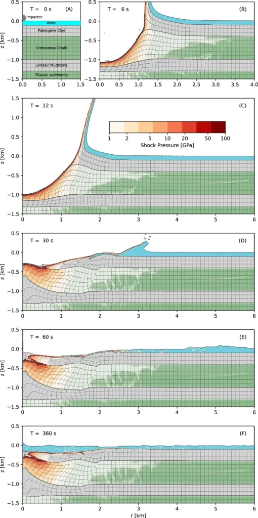

Simulations reconstruct the asteroid strike
To test crater formation, the team ran numerical simulations using the iSALE shock physics code. The best-fit model used a stony asteroid 160 m (525 feet) in diameter, striking at 15 km/s (9.3 mi/s).
Within 12 seconds, the impact excavated a transient crater 1 km (0.6 miles) deep and 3 km (1.9 miles) wide. Collapse and modification followed, sediments slumped inward, a central uplift rose, and concentric faults developed around the rim.
Water rapidly surged back into the cavity, scouring resurge scars visible in the seismic data. Modeling also suggests the impact generated a rim-wave tsunami across the shallow North Sea, followed by prolonged seiches that redistributed ejecta for hours or days.
The simulation assumed a vertical trajectory for simplicity, but seismic fault asymmetry shows the impactor likely struck at a low angle from the west-northwest. This is supported by curved radial faults and a 300 m (984 feet) offset between the central uplift and crater center.
Degassing of chalk and unusual crater morphology
The seismic data revealed unusual features in the chalk bedrock beneath Silverpit. The top of the central uplift is flat-topped and heavily pitted, unlike the classic sharp peaks seen in many complex craters.
The chalk layer is significantly thinned beneath the crater floor, with an estimated volume loss of 0.9–2.2 km3 (0.2–0.5 mi3). Researchers interpret this as the result of thermal decomposition of calcium carbonate (CaCO3) under shock pressures exceeding 25 GPa, producing CO2 and leaving pits from fluid escape.
This process, called devolatilization, has been hypothesized in Martian craters but rarely documented on Earth. At Silverpit, it may have produced an explosive “secondary ejecta plume” during crater modification, leaving the chaotic pitted morphology now imaged in seismic data.
Secondary craters preserved in marine sediments
The discovery of probable secondary craters around Silverpit is scientifically significant. On Earth, erosion usually erases such small features within thousands of years.
At Silverpit, rapid burial under marine sediments preserved them. The pits, up to 5% the size of the main crater, match scaling relationships for secondary craters observed on other planetary bodies.
Their preservation allows scientists to study ejecta emplacement in a marine setting, offering insights into how impacts reshape Earth’s seafloor, processes difficult to reconstruct elsewhere.
Expanding the catalog of Earth’s impact craters
Silverpit adds to a small but growing list of confirmed marine impact craters. Out of roughly 200 recognized impact structures worldwide, only about 33 are marine, despite oceans covering most of Earth.
Unlike the massive Chicxulub (180 km / 112 miles) or Chesapeake Bay (85 km / 53 miles) craters, Silverpit is modest in size. Yet its exceptional preservation makes it one of the clearest examples of a small marine impact.
The findings also strengthen comparisons with other recently studied craters, such as Nadir Crater offshore Africa, which is similarly imaged in 3D seismic. Together, these discoveries improve understanding of how impact dynamics vary in marine versus continental targets.
For planetary science, Silverpit demonstrates that even small impacts can generate tsunamis, secondary craters, and volatile release. Its preserved features may serve as a terrestrial analog for craters on icy satellites or Mars.
Remaining uncertainties and future research
Despite the strong evidence, some uncertainties remain. Only two shocked grains have been identified so far, and future drilling may be needed to recover more definitive petrographic samples.
Depth ties between seismic reflections and borehole samples involve some uncertainty due to drilling methods, though multiple checks suggest minimal contamination.
The numerical simulations assumed a vertical trajectory; full 3D oblique models are needed to better replicate observed asymmetries.
Finally, while devolatilization explains the pitted morphology of the chalk, confirming the process will require direct core samples.
References:
1 Multiple lines of evidence for a hypervelocity impact origin for the Silverpit Crater – Uisdean Nicholson et al. – Nature Communications – https://doi.org/10.1038/s41467-025-63985-z – OPEN ACCESS

I’m a science journalist and researcher at The Watchers, contributing to the Epicenter edition, where I cover peer-reviewed scientific research and emerging discoveries across Earth and space sciences. With a background in astronomy and a passion for environmental science, I’ve worked in shark and coral conservation in Fiji, conducting reef and shark-behavior research, contributing to mangrove restoration, and earning PADI Open Water and Coral Reef Certifications. I bring a blend of scientific rigor and storytelling to illuminate the discoveries shaping our planet and beyond.
Commenting rules and guidelines
We value the thoughts and opinions of our readers and welcome healthy discussions on our website. In order to maintain a respectful and positive community, we ask that all commenters follow these rules.