
New AI-based seismic tomography reveals internal structure of Vulcano volcano, Sicily
Scientists from the University of Geneva (UNIGE) and Italy’s National Institute of Geophysics and Volcanology (INGV) developed the most accurate 3D model of the internal structure of the Vulcano volcano in northern Sicily, marking a breakthrough in volcanic risk assessment.

The Vulcano volcano. Credit: Brisk G
A new study published in Nature Communications on August 28 presents the highest-resolution 3D model yet of the interior of Vulcano volcano, located north of Sicily, Italy.
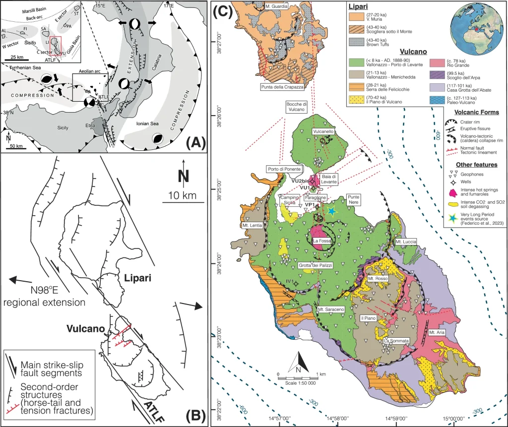
The volcano entered a phase of unrest in late 2021, characterized by very long-period seismic events, which are linked to the motion of magma and gas within the volcanic system. To investigate these processes, the research team deployed around 200 portable seismic sensors across the island. For one month, the instruments recorded natural ground vibrations across a wide frequency range.
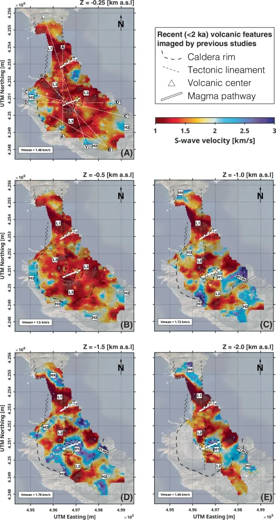
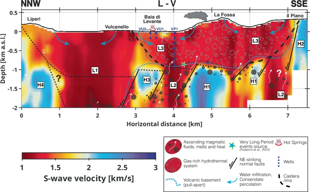
The dataset was processed using neural networks on UNIGE’s supercomputer Yggdrasil, enabling the creation of a detailed three-dimensional image of Vulcano’s interior. This approach, called seismic ambient noise tomography, takes advantage of the way seismic waves propagate more slowly through fluid-rich zones such as magma chambers.
According to Douglas Stumpp, lead author of the study and doctoral student at UNIGE, the model represents a breakthrough comparable to the transition from ultrasound to magnetic resonance imaging (MRI) in medicine. The results reveal the distribution of magmatic fluids in the volcano’s upper structure with unprecedented clarity.
“Until now, volcano seismology has primarily focused on earthquake signals beneath volcanoes. Large-scale studies have certainly helped to outline their internal structures, but very few have examined in detail what occurs deep underground,” Stumpp said.
“We used a seismic ambient noise tomography approach, acquired by a nodal network. To process the data we used neural networks, a technology that allows us to ‘X-ray’ volcanoes. This work was carried out as part of the joint master’s program of the Universities of Geneva and Lausanne (ELSTE).”
The study is the result of a collaboration between the University of Geneva (UNIGE) and Italy’s National Institute of Geophysics and Volcanology (INGV). It comes at a critical time: over 1 500 volcanoes worldwide are classified as active, but only about 30% are well studied. Meanwhile, more than 800 million people live close to volcanoes, making advances in early-warning systems vital.
Vulcano itself is one of the most closely watched in Europe. The island, which gives its name to all volcanoes, last erupted between 1888 and 1890 but remains restless. Its most recent awakening in 2021 was marked not only by unusual seismic activity, but also by rising fumarolic temperatures, increased carbon dioxide and sulfur dioxide emissions, and ground uplift in La Fossa crater.
The Italian Civil Protection raised the alert level during the crisis, only to lower it again in 2023; however, monitoring continues.
The new high-resolution model provides researchers with a “photograph” of the volcano’s shallow plumbing system. It reveals networks of low-velocity zones beneath La Fossa, linked to magma-rich and fluid-saturated regions, and high-velocity domains that may correspond to cooled magmatic intrusions.
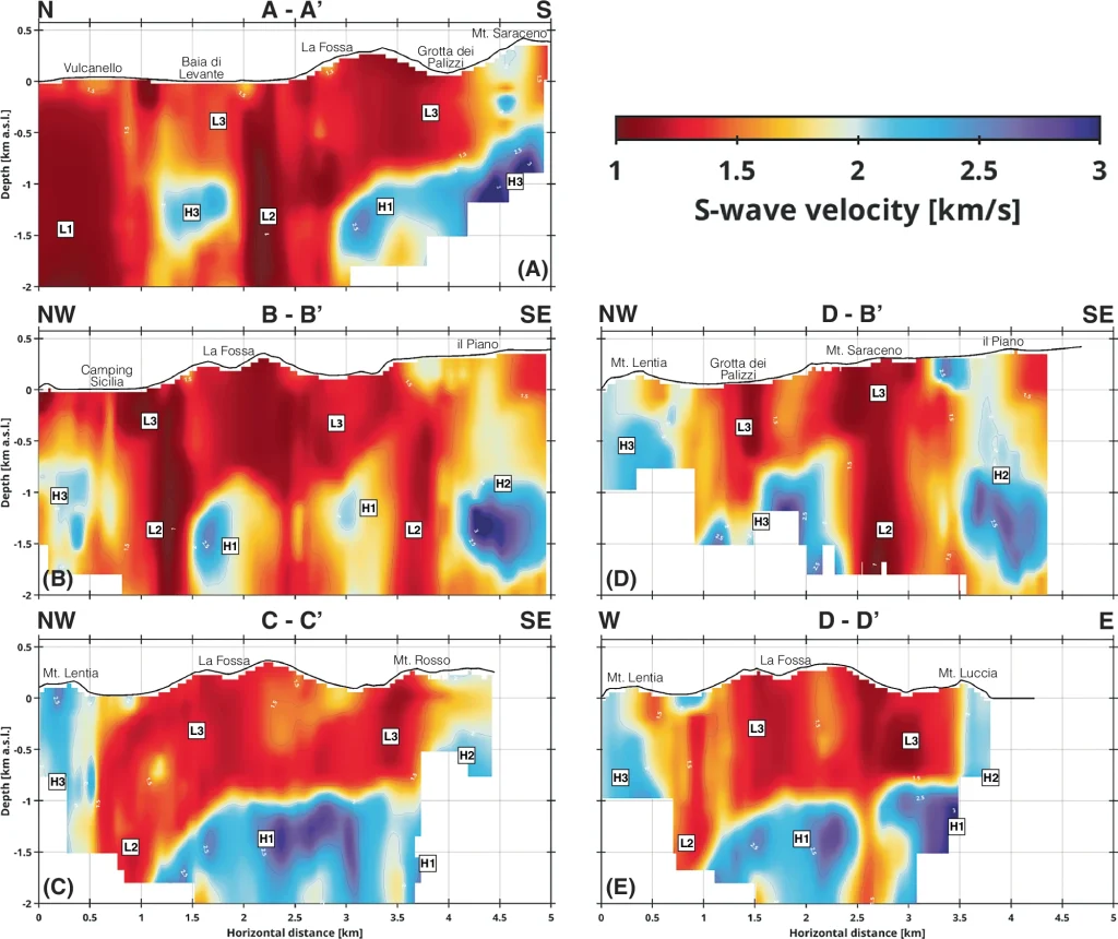
These features are closely tied to local tectonic faults, suggesting that volcanic unrest can be driven not only by new magma intrusions but also by fault activity that mobilizes fluids already present in the system.
While the findings do not yet enable direct eruption forecasts, they represent a leap forward in risk management. “If we could process data from seismic ambient noise nodal tomography in real time, assisted by neural networks, we could analyze the behaviour of each area of the volcanic system as it unfolds — and thus design dynamic, adaptable evacuation plans,” Stumpp said.
Achieving this vision will require faster computational methods, but researchers are optimistic. By combining dense sensor networks, artificial intelligence, and supercomputing, the team has demonstrated a way to capture volcanoes in unprecedented detail.
References:
1 Douglas Sami Stumpp, Iván Cabrera-Pérez – Neural Network Nodal Ambient Noise Tomography of a transient plumbing system under unrest, Vulcano, Italy – https://doi.org/10.1038/s41467-025-62846-z – Nature Communications – August 27, 2025
2 Mapping the heart of volcanoes when they wake up – University of Geneva – August 28, 2025

I’m a science journalist and researcher at The Watchers, contributing to the Epicenter edition, where I cover peer-reviewed scientific research and emerging discoveries across Earth and space sciences. With a background in astronomy and a passion for environmental science, I’ve worked in shark and coral conservation in Fiji, conducting reef and shark-behavior research, contributing to mangrove restoration, and earning PADI Open Water and Coral Reef Certifications. I bring a blend of scientific rigor and storytelling to illuminate the discoveries shaping our planet and beyond.
Commenting rules and guidelines
We value the thoughts and opinions of our readers and welcome healthy discussions on our website. In order to maintain a respectful and positive community, we ask that all commenters follow these rules.