
Coral skeletons reveal medieval tsunami and long-term seismic threat to the Caribbean
A newly dated medieval tsunami between 1381 and 1391 CE struck Anegada, the northernmost of the British Virgin Islands, when an M8.0 or greater earthquake ruptured the Puerto Rico Trench, according to an open-access study published in Geophysical Research Letters on October 8, 2025.
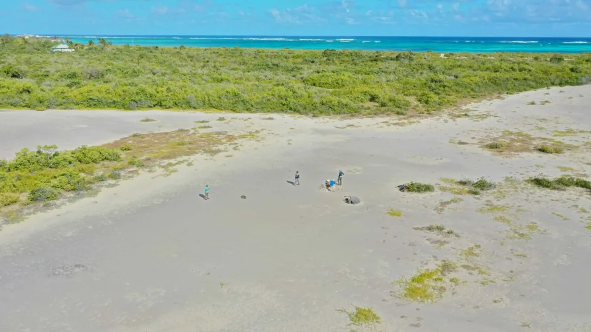
The tiny figures in this drone photo are standing near one of the stranded coral boulders, showing how far inland the tsunami carried it. Credit: Michaela Spiske
In the late 14th century, an M8.0 or greater earthquake shook the northeastern Caribbean and launched a tsunami toward the low island of Anegada.
Floodwaters swept coral and limestone debris across the island, scattering massive coral boulders hundreds of meters inland. Some of these still rest where the waves left them more than 600 years ago.
Researchers have now dated the event precisely between 1381 and 1391 CE, based on uranium-thorium analyses of coral skeletons. The study, published in Geophysical Research Letters on October 8, 2025, was led by Hali Kilbourne of the University of Maryland, with collaborators from the University of Washington, the US Geological Survey, and international research centers in France and Taiwan.
This tsunami remains the only known geological evidence of a great earthquake in the eastern Puerto Rico Trench. Its discovery fills a major gap in the Caribbean’s seismic record, offering both historical perspective and modern warning.
The lead author explained that coral skeletons act like time capsules. They record the exact year they died, so by analyzing their chemistry, researchers can reconstruct the timeline of the disaster.
How coral skeletons recorded the wave
The researchers analyzed twenty coral samples collected on Anegada. Fourteen came from nine inland boulders believed to have been stranded by the tsunami, while six came from storm rubble at the shoreline.
Uranium-series dating relies on the decay of uranium absorbed by coral during its lifetime into thorium after death. By measuring the ratio of these isotopes, scientists can determine how long ago the coral stopped growing.
The most precise ages came from two core samples, 13AN5a and 13AN5b, drilled from a hemispherical coral colony of Pseudodiploria strigosa near Bones Bight. By counting annual growth bands between the inner sample and the coral’s surface, the team determined the colony was killed by the tsunami between 1381 and 1391 CE.
“Corals have annual density bands much like tree rings,” Kilbourne said. “We counted those bands and linked them to the uranium-thorium ages, giving us a year-by-year bracket.”
The outermost growth bands suggested that the corals died during the warm season. The study concludes the tsunami likely struck between mid-summer and early autumn, when Caribbean waters were at their highest energy.

An island uniquely exposed to tsunami energy
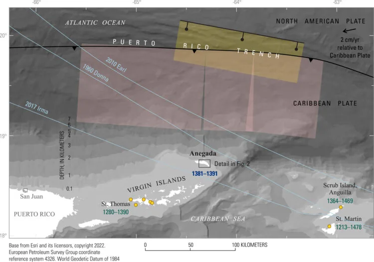
Anegada’s location makes it far more vulnerable to tsunamis than most Caribbean islands. It lies directly south of the Puerto Rico Trench, where the Caribbean Plate slides beneath the North American Plate.
Unlike its neighbors, Anegada lacks a broad continental shelf. Its seabed drops steeply into deep ocean, meaning waves generated by a trench earthquake can race toward the island with little energy loss.
When the medieval quake ruptured, models suggest it produced an M8.0 or greater event, powerful enough to displace large coral boulders inland by several hundred meters. Those boulders remain silent witnesses to the wave’s force.
Written records from the region go back only about five centuries, but no accounts mention such a tsunami. Geological deposits, however, allow scientists to look back thousands of years.
The 14th-century event demonstrates that even long-quiet subduction zones can produce major earthquakes and tsunamis, with recurrence intervals possibly spanning several thousand years.
Testing the evidence in the lab
To confirm the timing, the research team conducted laboratory tests at two leading isotope facilities. The core samples were analyzed at the High-Precision Mass Spectrometry and Environment Change Laboratory at National Taiwan University, and the hand samples were processed at CEREGE in France.
Each sample underwent multiple quality checks to ensure it had not been altered since burial. X-radiographs and X-ray diffraction were used to detect calcite formation or dissolution, which can distort isotopic ratios.
All but one sample, known as AN11, passed these reliability tests. AN11 showed slight contamination and was excluded from the main analysis.
The team also compared uranium-thorium ages with 41 radiocarbon ages from other coral fragments. Using the Marine20 calibration curve and a local reservoir correction of ΔR = −216 ± 44 radiocarbon years, the results confirmed that most corals date to the same 14th-century event.
This combination of geochronology and cross-checking provided one of the most precise tsunami chronologies ever achieved in tropical geology.
A wider Caribbean impact
The geological signature of the medieval tsunami extends beyond Anegada. Sediment layers of the same age appear on nearby islands, including St. Thomas, Anguilla, and St. Martin, more than 200 km (124 miles) away.
These layers contain sand, shell fragments, and coral debris deposited well inland, indicating a single large regional event rather than multiple local storms.
Numerical simulations reproduce similar flooding patterns when modeling an M8.0 or greater earthquake on the Puerto Rico Trench. The models suggest either extensional faulting within the descending North American Plate or thrust rupture at the boundary with the Caribbean Plate could have produced the wave.
Researchers estimate that earthquakes of this scale recur on timescales of several thousand years. That makes the medieval tsunami an extremely rare but still relevant event, a geological warning for coastal infrastructure planning today.
For comparison, hurricanes like Donna (1960), Earl (2010), and Irma (2017) produced strong winds and storm surges, yet left little permanent geological trace. Only a tsunami could have moved the massive coral boulders now found inland on Anegada.
Why it matters for modern hazard planning
The study’s precise dating has major implications for regional safety and preparedness. It confirms that the Puerto Rico Trench is capable of producing great earthquakes and destructive tsunamis, even though none have been recorded in written Caribbean history.
“If you are building critical facilities near the coast, you must account for this level of seismic risk,” said Atwater. “It is rare, but it is real.”
Regional exercises such as Caribe Wave, organized by NOAA and UNESCO, now incorporate trench-based tsunami scenarios. In 2024, nearly 500 000 participants across the Caribbean practiced evacuation and communication procedures for such an event.
Having a well-dated example provides a real historical foundation for these simulations, helping local governments prepare for the kind of disaster that might otherwise seem unimaginable.
The tsunami of 1381–1391 CE stands as both a geological discovery and a warning written in coral, reminding the region that deep time can inform present-day safety.
Coral archives and climate connections
The coral skeletons also preserve environmental data. Their chemistry records seawater temperatures and salinity, allowing scientists to reconstruct ocean conditions during the late medieval period.
Kilbourne and her colleagues plan to continue studying these samples to compare 14th-century sea-surface temperatures with those of today.
Previous work by Yuan-yuan Xu and others has already shown that coral isotopes can trace sub-annual changes in ocean temperature. The Anegada samples may extend that record further, bridging the medieval climate with modern warming trends.
In this way, the same coral skeletons that reveal an ancient tsunami also record centuries of ocean change, linking the study of natural disasters to long-term climate science.
A message from the past
The Anegada tsunami shows that the Caribbean’s apparent calm can be deceptive. Great earthquakes along the Puerto Rico Trench are rare but inevitable over geological time.
By analyzing the coral boulders with atomic precision, scientists have resurrected the story of one such event that occurred nearly 650 years ago.
The corals, stranded far from the sea that once nurtured them, now serve as a warning. They show that the region’s most dangerous earthquakes may come not from what people remember, but from what the land remembers for them.
References:
1 Coral skeletons left by a medieval tsunami whisper warning for Caribbean region – UW News – October 16, 2025
2 Dating a Medieval Tsunami With Uranium-Series Techniques on Caribbean Corals – K. Halimeda Kilbourne et al. – Geophysical Research Letters – October 8, 2025 – https://doi.org/10.1029/2024GL114448

I’m a science journalist and researcher at The Watchers, contributing to the Epicenter edition, where I cover peer-reviewed scientific research and emerging discoveries across Earth and space sciences. With a background in astronomy and a passion for environmental science, I’ve worked in shark and coral conservation in Fiji, conducting reef and shark-behavior research, contributing to mangrove restoration, and earning PADI Open Water and Coral Reef Certifications. I bring a blend of scientific rigor and storytelling to illuminate the discoveries shaping our planet and beyond.
Commenting rules and guidelines
We value the thoughts and opinions of our readers and welcome healthy discussions on our website. In order to maintain a respectful and positive community, we ask that all commenters follow these rules.