
The 2018 Palu earthquake and tsunami reshaped understanding of strike-slip hazards
A magnitude M7.5 earthquake struck Central Sulawesi at 18:02 LT (10:02 UTC) on September 28, 2018, unleashing a locally amplified tsunami, catastrophic liquefaction and slope failures that killed more than 4 300 people.

Collapsed bridge after the September 2018 earthquake and tsunami that hit Central Sulawesi. Credit: N.Hariadi
The mainshock began at 18:02 LT (10:02 UTC) on September 28, 2018, along the Palu–Koro fault system in Donggala Regency, north of Palu. The rupture reached magnitude M7.5 and extended for roughly 150 km (93 miles).
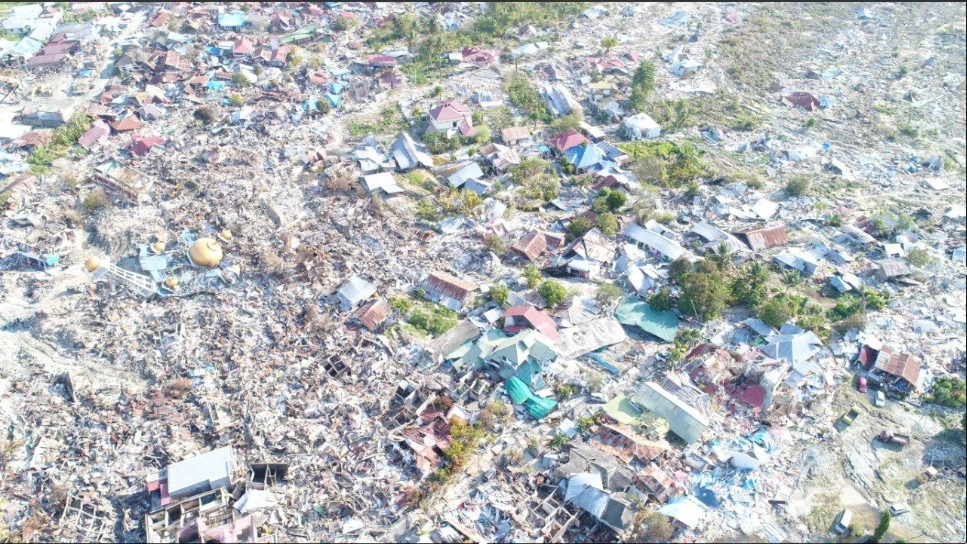
Strong shaking caused buildings across Palu and the surrounding towns to collapse. Bridges and roads were fractured, hospitals were damaged, and communication networks failed within minutes.
Yet the earthquake was only the first stage of the disaster. Within 3–8 minutes, tsunami waves entered Palu Bay and struck densely populated coastal areas. Eyewitness videos captured surges overtopping seawalls and racing inland before residents had time to react.
Runup heights varied greatly across the bay. Post-event surveys recorded typical values of 4–7 m (13–23 feet) and maxima of 10–11 m (33–36 feet) near the bay head. Inundation depths of 2–4 m (6–13 feet) destroyed homes, mosques, markets and coastal infrastructure.
Together with catastrophic liquefaction in Petobo, Balaroa and Jono Oge, the event produced one of Indonesia’s deadliest disasters in decades, with about 4 300 fatalities and many thousands displaced.
Why a strike-slip earthquake produced a destructive tsunami
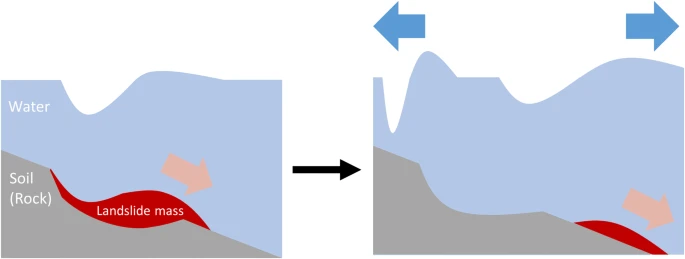
Strike-slip earthquakes involve lateral fault movement, which usually does not generate strong vertical displacement of the seabed. For this reason, they are rarely associated with major tsunamis.
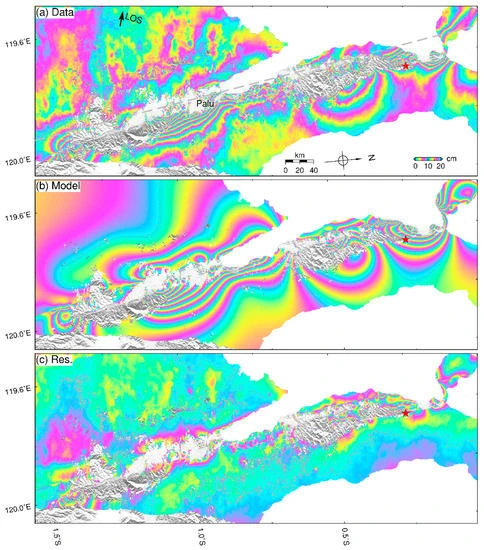
The Palu case defied this expectation because several unusual mechanisms acted together. Seismological inversions suggest localised dip-slip components of up to 1–3 m (3–10 feet) along fault strands entering Palu Bay. This created limited but significant vertical seabed movement.
The rupture itself propagated at supershear speeds of 4–5 km/s (2.5–3.1 miles/s). Supershear ruptures radiate concentrated energy in Mach fronts, which may have enhanced local seabed deformation and slope failure triggers.
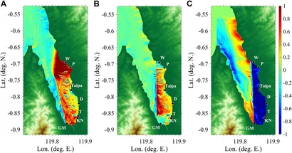
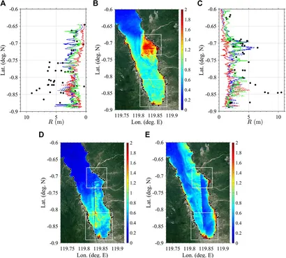
Most importantly, multiple coastal and submarine landslides inside Palu Bay contributed short-wavelength tsunami sources. Models incorporating landslide volumes of 0.02–0.07 km³ (0.005–0.017 mi³) reproduce the short-period pulses seen in tide gauges and videos far better than earthquake-only models.
Finally, Palu Bay’s geometry, 30 km (19 miles) long and just 7 km (4 miles) wide in places, funnelled and amplified the waves. Narrow bays are known to act as natural resonators, concentrating energy at the bay head.
Landslides and resonance inside Palu Bay
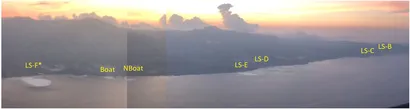
Eyewitnesses recorded large sections of coastal land collapsing into the water minutes after the earthquake. Submarine slope failures are harder to confirm, but bathymetric surveys and satellite imagery reveal scars consistent with landslide sources.
These landslides generated waves with very short periods, a diagnostic feature also seen in tide-gauge records at Pantoloan and Mamuju. The short, steep waves caused disproportionate destruction along the bay’s narrow shores.
Numerical studies since 2019 have converged on dual-source models, a combination of tectonic slip and landslide input. These models better match the observed wave arrival times, heights and inundation patterns in Palu City.
The bay’s resonance characteristics also amplified the waves. Its elongated basin shape allowed even small landslides to produce focused surges in Palu’s waterfront districts, magnifying damage.
Because the landslides occurred almost simultaneously with the earthquake, no realistic warning system could have provided evacuation time. For residents, the shaking itself was the only effective signal.
Supershear rupture and its unusual effects
Supershear rupture occurs when an earthquake rupture front travels faster than the shear-wave velocity of the crust. This phenomenon is rare but important, as it changes how energy is distributed.
In Palu, geodetic and seismological analyses confirm rupture velocities exceeding 4 km/s (2.5 mi/s). The fault’s straight geometry likely allowed rupture to accelerate to this speed, producing intense forward-directed shaking.
Supershear dynamics may have contributed to unusual damage patterns in Palu. Concentrated ground motion could explain why some areas experienced disproportionately severe destruction relative to distance from the fault.
Models also suggest supershear kinematics may enhance tsunami excitation in near-field zones, particularly when combined with localized vertical slip. Palu provides one of the clearest natural examples of this effect, making it a key reference for future hazard assessments.
This recognition has led researchers to include rupture velocity scenarios, not just magnitude and depth, in updated tsunami hazard modelling for Indonesia.
Liquefaction and flowslides that buried entire districts
Liquefaction transformed the disaster into one of Indonesia’s most complex catastrophes. In Palu’s lowland suburbs, water-saturated soils lost strength during shaking, turning into fluid-like masses.
Entire neighbourhoods, including Petobo, Balaroa and Jono Oge, shifted hundreds of metres as the ground beneath them flowed laterally. Buildings, trees and roads were carried along like rafts on a river of mud.
These flowslides killed thousands who had survived the tsunami. They also obliterated farmland, destroyed irrigation systems and left land unsuitable for rebuilding.
Post-event mapping revealed displacements of up to 500 m (1 640 feet) in some zones. Geotechnical analyses linked the phenomenon to loose alluvial deposits, shallow groundwater and long-period shaking from the supershear rupture.
Liquefaction at this scale in an urban environment was previously considered unlikely. Palu became a stark reminder that soil behaviour under seismic loading can rival the tsunami in destructive power.
Lessons for warning and preparedness
The Palu disaster underscored critical gaps in warning and preparedness. Indonesia’s national tsunami warning system, designed for far-field threats, could not react within the 3–8 minute window of local tsunami arrival.
Many residents received alerts too late, or not at all, due to damaged communications and power outages. Survival often depended on immediate self-evacuation triggered by the shaking itself.
Preparedness experts now emphasize education: strong shaking in coastal zones must be taken as a natural tsunami warning. Evacuation routes, vertical shelters and community drills are essential for bays with short lead times.
At the scientific level, Palu demonstrated the need for dense coastal monitoring networks. Local tide gauges, real-time seafloor sensors and updated bathymetric surveys are now seen as critical for Indonesia’s future tsunami resilience.
For urban planning, Palu highlighted the vulnerability of developments built on young, waterlogged sediments. Land-use restrictions and stronger geotechnical planning are being considered to reduce exposure to liquefaction hazards.
Scientific significance and continuing research
Since 2018, Palu has become one of the most studied earthquake–tsunami events in recent history. It has spurred advances in rupture dynamics, landslide modelling, and compound hazard assessment.
Studies between 2020 and 2023 favour dual-source explanations combining fault slip and landslides. They also emphasize the amplifying role of narrow-bay geometry.
Newer bathymetric surveys continue to refine the locations and volumes of suspected submarine landslides, reducing uncertainty in models. InSAR and GPS data have constrained fault offsets and rupture propagation.
Researchers are now testing whether supershear ruptures in other strike-slip systems, such as the San Andreas in California or faults in Turkey and New Zealand, could pose similar compound risks. Palu has become a reference event in global hazard planning.
Despite progress, uncertainties remain about the precise sequence of slope failures and the quantitative role of supershear dynamics in tsunami excitation. Future research will rely on improved seabed mapping and higher-resolution numerical models.
Broader implications for coastal societies
The Palu earthquake and tsunami remind us that rare combinations of processes can devastate coastal cities. Strike-slip faults are not inherently safe from tsunami risk, especially when they intersect steep terrain and enclosed bays.
Cities worldwide with similar settings, such as San Francisco Bay, Turkey’s Gulf of İzmit, or fjords in New Zealand, may need to reassess their hazard exposure. While each differs geologically, the Palu case shows that lateral faults can create vertical displacement, slope failures, and resonance effects under the right conditions.
For communities, the core lesson is that warning times may be measured in minutes or less. Preparedness must focus on rapid evacuation and resilient urban planning rather than reliance on distant alerts.
For scientists, Palu highlights the need for integrated, cross-disciplinary hazard studies that combine seismology, geotechnical engineering and coastal hydrodynamics. Only such approaches can capture the true complexity of compound disasters.
References:
1 The 2018 Mw 7.5 Palu Earthquake: A Supershear Rupture Event Constrained by InSAR and Broadband Regional Seismograms – Jin Fang et al. – MDPI – June 3, 2019 – https://doi.org/10.3390/rs11111330 – OPEN ACCESS
2 Submarine landslide source models consistent with multiple tsunami records of the 2018 Palu tsunami, Sulawesi, Indonesia – Kenji Nakata et al. – Earth, Planets and Space – April 3, 2020 – https://doi.org/10.1186/s40623-020-01169-3 – OPEN ACCESS
3 New High-Resolution Modeling of the 2018 Palu Tsunami, Based on Supershear Earthquake Mechanisms and Mapped Coastal Landslides, Supports a Dual Source – Lauren Schambach et al. – Frontiers – January 11, 2021 – https://doi.org/10.3389/feart.2020.598839 – OPEN ACCESS

I’m a science journalist and researcher at The Watchers, contributing to the Epicenter edition, where I cover peer-reviewed scientific research and emerging discoveries across Earth and space sciences. With a background in astronomy and a passion for environmental science, I’ve worked in shark and coral conservation in Fiji, conducting reef and shark-behavior research, contributing to mangrove restoration, and earning PADI Open Water and Coral Reef Certifications. I bring a blend of scientific rigor and storytelling to illuminate the discoveries shaping our planet and beyond.
Commenting rules and guidelines
We value the thoughts and opinions of our readers and welcome healthy discussions on our website. In order to maintain a respectful and positive community, we ask that all commenters follow these rules.