
1985 M8.0 Mexico City earthquake and the birth of earthquake early warning
When an M8.0 earthquake struck Mexico City at 13:17 UTC (07:17 LT) on September 19, 1985, shaking lasted nearly four minutes and toppled more than 400 buildings, killing over 10 000 people. The disaster revealed how resonant lakebed soils could amplify distant seismic waves into catastrophic motion, a finding that reshaped earthquake science and led to the world’s first public early warning system.

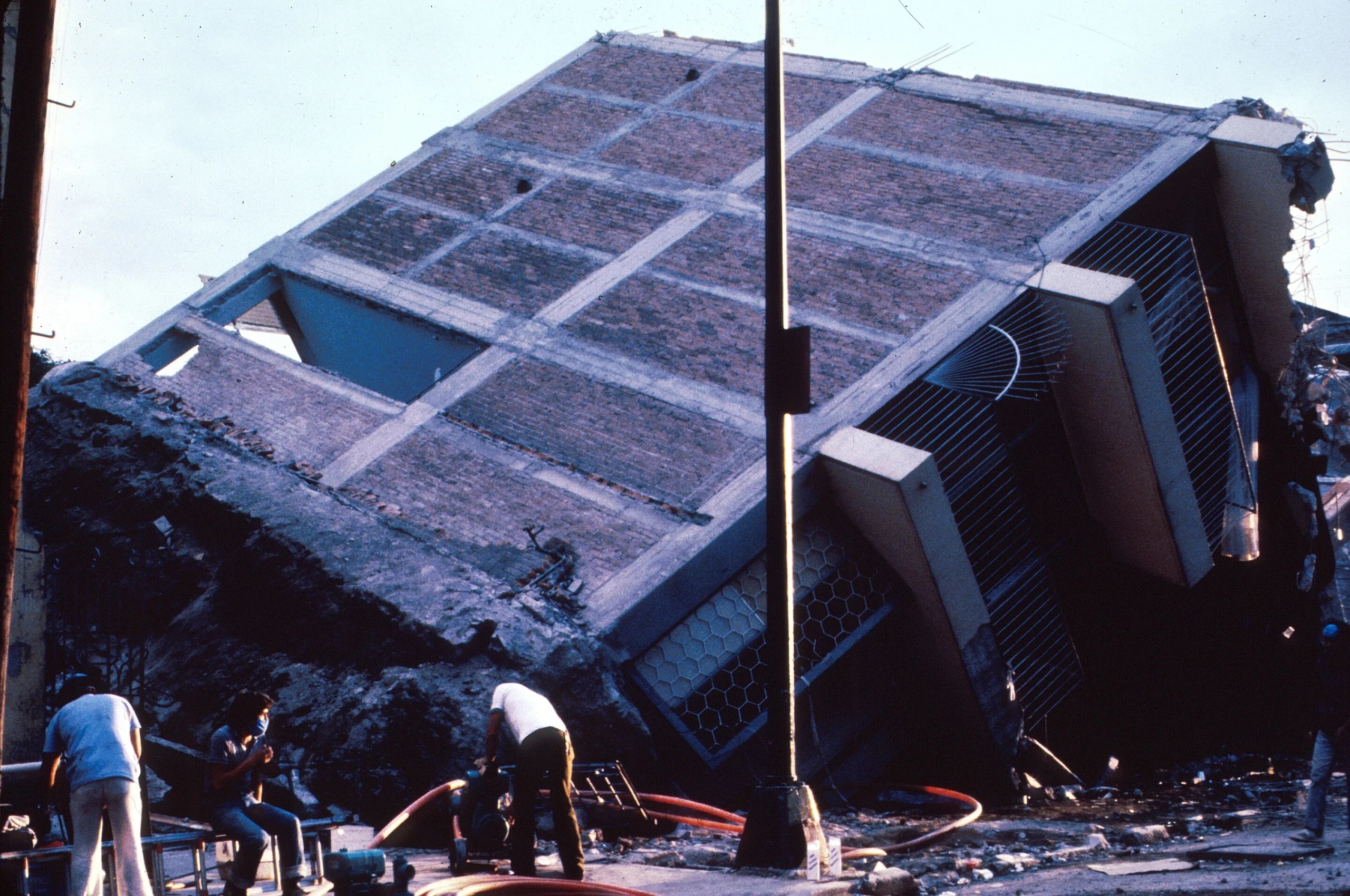
Collapsed General Hospital in Mexico City. Credit: USGS
- September 19, 2025 marks the 40th anniversary of the 1985 Mexico City earthquake, one of the deadliest urban disasters of the modern era. Four decades on, its lessons remain deeply relevant not only for Mexico but for every megacity built on vulnerable ground.
- The earthquake demonstrated that local geology can be as decisive as magnitude. Despite being 350 km (217 miles) from the rupture, Mexico City suffered catastrophic losses because of resonance effects in lakebed clays.
- It also showed that building resonance matters. Many mid-rise structures built in the mid-20th century had natural vibration periods that matched the amplified ground motion, increasing their vulnerability even when they complied with existing codes.
- Seismic microzonation became a lasting contribution to earthquake science. By dividing Mexico City into zones based on soil amplification, engineers created a model for risk assessment now used worldwide, from Los Angeles to Tokyo.
- Mexico’s SASMEX provided proof that alerts could be issued seconds to minutes before damaging shaking, giving critical time for protective actions. This resulted in the creation of the first public earthquake early warning system.
In the early hours of September 19, 1985, Mexico City was jolted by one of the deadliest urban earthquakes of the 20th century.
Though the rupture occurred nearly 350 km (217 miles) away off the Pacific coast of Michoacán, the capital endured catastrophic shaking. The city’s ancient lakebed amplified the seismic waves, turning distant vibrations into prolonged motion that toppled buildings and exposed deep flaws in construction practices.
The event was both a national tragedy and a turning point in seismic science.
Human and structural impact
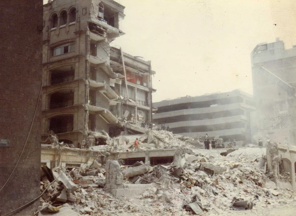
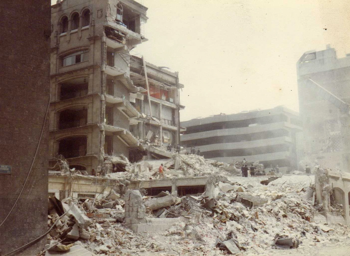
This earthquake killed more than 10 000 people in Mexico City, with some estimates suggesting higher numbers due to undocumented fatalities. At least 30 000 people were injured, and more than 250 000 were immediately displaced as thousands of residential buildings were destroyed or declared unsafe.
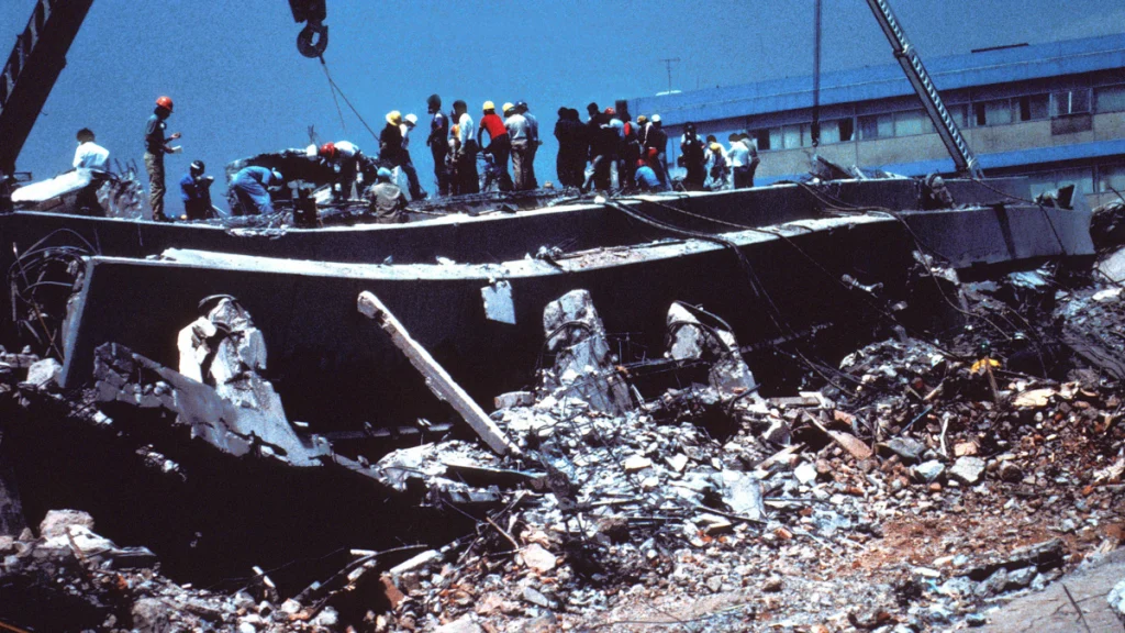
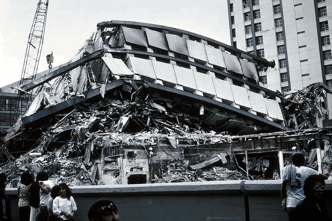
Hospitals, schools, and offices collapsed, severely disrupting medical and educational services. One of the most symbolic losses was the collapse of the Nuevo León apartment complex in the Tlatelolco area, where hundreds of residents died. Fires broke out due to ruptured gas pipelines, while power outages, water failures, and communication breakdowns hampered rescue operations.
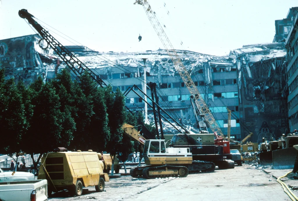
In total, 412 buildings collapsed outright and more than 3 000 suffered severe structural damage. An additional 100 000 structures required repair or demolition. The scale of the disaster was unprecedented for a modern megacity, and it highlighted deep vulnerabilities in urban infrastructure.
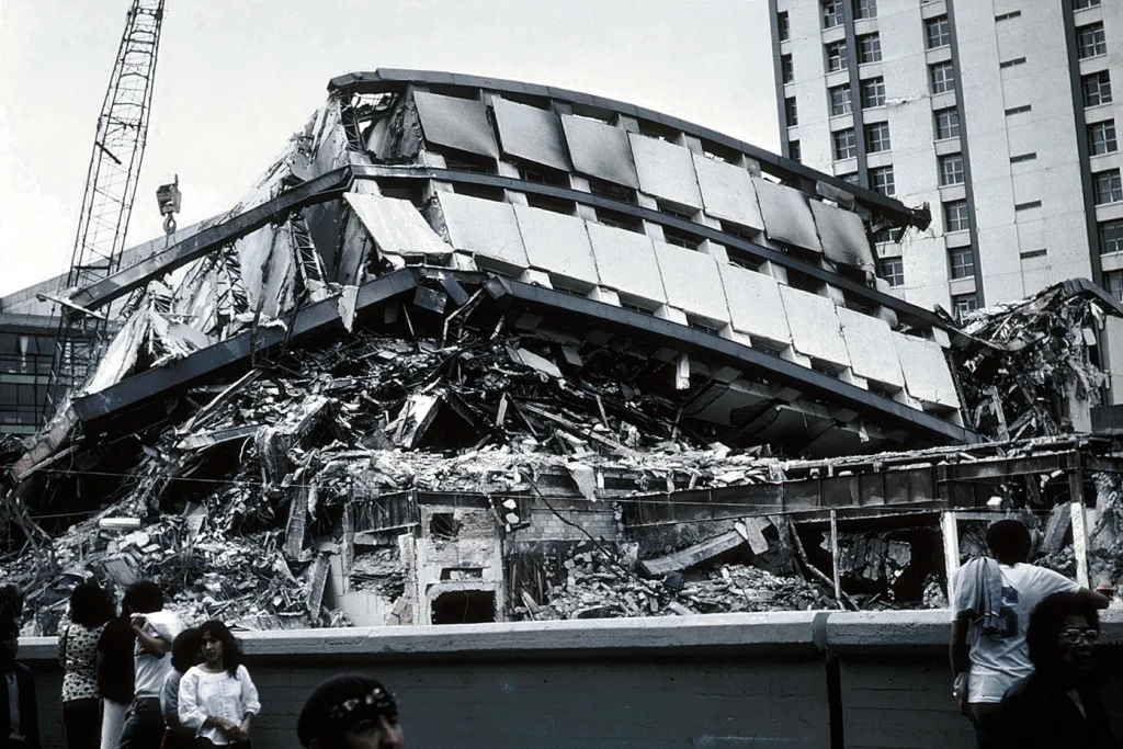
 Nuevo León apartment building; part of the structure was only slightly damaged, while another part of it collapsed. Credit: USGS
- Collapsed Conalep building. Credit: Roberto Esquivel Sánchez family
- Apartment Complex Pino Suárez, in the wake of the earthquake. Credit: USGS
- Collapsed General Hospital in Mexico City. Credit: USGS

Why Mexico City suffered so severely
Mexico City is situated in a closed basin once occupied by Lake Texcoco. The soils are composed of saturated clays and silts with very low shear wave velocities. When seismic waves entered the basin, they slowed down and transferred energy into strong, long-period oscillations. These oscillations were amplified by factors of 5–50 compared to nearby rock outcrops.
Many residential and office buildings constructed between the 1950s and 1970s were 6–15 stories tall. Their natural oscillation periods coincided with the amplified wave periods in the lakebed zone, typically around 2–5 seconds. This coincidence caused resonance, where shaking intensity within the buildings increased dramatically, leading to widespread collapse.
While earthquakes closer to Mexico City typically generate short bursts of strong motion, the Michoacán rupture produced sustained low-frequency waves that reverberated within the basin.
In the worst-hit neighborhoods, shaking lasted three to four minutes. Prolonged motion exhausted the structural capacity of many buildings that might have survived shorter bursts.
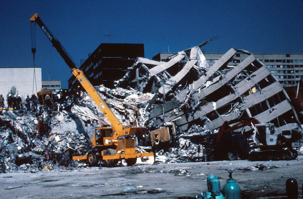
- Collapsed upper stories and construction equipment at work at the Ministry of Telecommunications and Transportation building. Credit: USGS
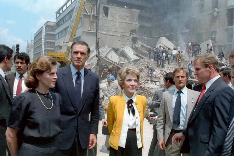
- First ladies Paloma Cordero of Mexico (left) and Nancy Reagan of the United States (right) with U.S. Ambassador to Mexico, John Gavin observing the damage done by the earthquake. Credit: White House Photographic Office: 1981-89 Collection
- Eight-story frame structure with brick infill walls broken in two. The foundation also came off. Credit: USGS


Although building codes had been updated after the 1957 earthquake, enforcement was inconsistent. Many mid-rise structures incorporated “soft stories” with open ground floors for shops or parking, a design highly vulnerable to lateral loads. Others had poor-quality concrete and inadequate steel reinforcement. These vulnerabilities became clear after 1985, forcing a reevaluation of engineering standards.
Seismic microzonation after 1985
One of the most enduring legacies of the earthquake was the scientific push for seismic microzonation, the detailed mapping of how ground conditions affect earthquake shaking across a city.
Investigations showed that damage was not uniform. The lakebed areas in central and eastern Mexico City experienced catastrophic collapses, while hillside districts on volcanic rock reported relatively minor losses. To formalize these differences, researchers at the National Autonomous University of Mexico (UNAM) and the city’s Department of Public Works developed the first official microzonation maps.
The city was divided into three principal zones:
- Zone I (Hills): areas on volcanic rock and lava flows, where amplification is minimal.
- Zone II (Transition): areas between hills and lakebed, where amplification is moderate.
- Zone III (Lakebed): the softest soils, where amplification is strongest.
In subsequent updates, Zone III was subdivided into four subzones to reflect differences in soil depth and properties. These maps became a cornerstone of seismic design. Structures in lakebed zones now require more stringent foundation designs, higher safety factors, and in some cases, construction restrictions.
The microzonation also guided the installation of an expanded strong-motion accelerograph network. Hundreds of sensors were deployed to measure shaking in real time and refine hazard models. The approach pioneered in Mexico City later influenced seismic zoning in other cities with sedimentary basins, such as Los Angeles and Tokyo.

From disaster to first early warning system
The 1985 earthquake also sparked a second innovation: earthquake early warning. Scientists realized that because Mexico City is hundreds of kilometers from the main subduction zone, there is a natural delay between the rupture offshore and the arrival of damaging waves in the basin. If seismic stations were installed along the coast, they could detect earthquakes early and issue alerts to the capital.
This idea led to the Seismic Alert System (SAS), launched in 1991. Initially, it consisted of 12 sensors along the Guerrero coast, designed to detect large subduction earthquakes. By 1993, the system was expanded to broadcast alerts to the public.
In the early 2000s, a parallel system was built for Oaxaca. Both networks were merged in 2005 to form SASMEX, which is the Mexican Seismic Alert System, managed by the non-profit Centro de Instrumentación y Registro Sísmico (CIRES).
SASMEX works by detecting the first-arriving P-waves, which travel faster but cause less damage, and using them to predict the strength of the slower, more destructive S-waves. If the estimated magnitude and intensity exceed pre-set thresholds, alerts are issued. These are broadcast through television, radio, and more than 12 000 loudspeakers across Mexico City, and dedicated receivers in schools and public institutions.
Depending on the epicenter, the warning time for Mexico City ranges from a few seconds to more than a minute. For a megacity of over 20 million people, this lead time is enough to halt subway trains, shut down industrial operations, or allow residents to take protective action.
Legacy and lessons
The 1985 Mexico City earthquake remains one of the most significant disasters in modern urban history but its scientific and societal lessons extend beyond Mexico:
- The disaster showed that soil amplification can determine urban vulnerability more than fault distance.
- Building resonance is critical. Structures with natural periods matching ground motion are at greatest risk, even if they meet code requirements.
- Seismic microzonation is essential. Understanding local soil conditions is now standard practice in seismic risk assessment worldwide.
- Mexico pioneered the world’s first operational public earthquake alert system, a model now emulated in Japan, the United States, and other regions.
- Preparedness saves lives. Annual national drills on September 19 commemorate the disaster and reinforce public awareness.
Nearly four decades on, Mexico City still faces seismic risk. Informal housing and aging buildings remain fragile, code enforcement is uneven, and public response to alerts is not always consistent. Yet the frameworks created after 1985 — microzonation, dense seismic networks, early warning, and annual civic drills — continue to stand as pillars of resilience. They are both a living memorial to those lost and a blueprint for how megacities worldwide can confront the inevitability of future earthquakes.
References:
1 M8.0 – 1985 Michoacan, Mexico Earthquake – USGS – Accessed September 16, 2025
2 The Mexico Earthquake of September 19, 1985—A Study of Amplification of Seismic Waves in the Valley of Mexico with Respect to a Hill Zone Site – Shri Krishna Singh et al – November 1988 – https://doi.org/10.1193/1.1585496 – OPEN ACCESS

I’m a science journalist and researcher at The Watchers, contributing to the Epicenter edition, where I cover peer-reviewed scientific research and emerging discoveries across Earth and space sciences. With a background in astronomy and a passion for environmental science, I’ve worked in shark and coral conservation in Fiji, conducting reef and shark-behavior research, contributing to mangrove restoration, and earning PADI Open Water and Coral Reef Certifications. I bring a blend of scientific rigor and storytelling to illuminate the discoveries shaping our planet and beyond.
Commenting rules and guidelines
We value the thoughts and opinions of our readers and welcome healthy discussions on our website. In order to maintain a respectful and positive community, we ask that all commenters follow these rules.