
The 1929 M7.2 Grand Banks earthquake and tsunami reshaped Atlantic coasts
An offshore M7.2 earthquake known as the Grand Banks earthquake or the Laurentian Slope earthquake and sometimes the South Shore Disaster struck south of Newfoundland at 17:02 local time (LT) on November 18, 1929. The shaking triggered a massive 200 km³ (48 miles³) submarine slump that ruptured 12 trans-Atlantic cables and generated a tsunami that devastated more than 40 villages on the Burin Peninsula, killing 28 people.
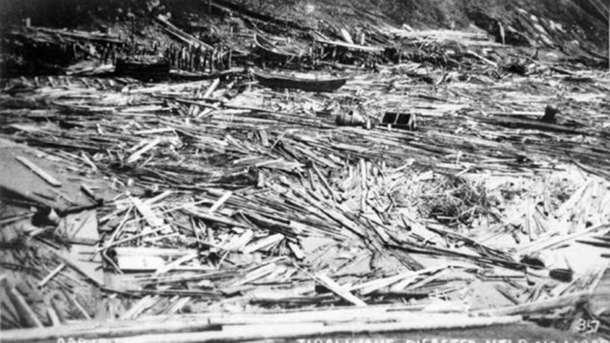
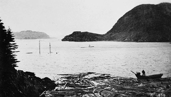
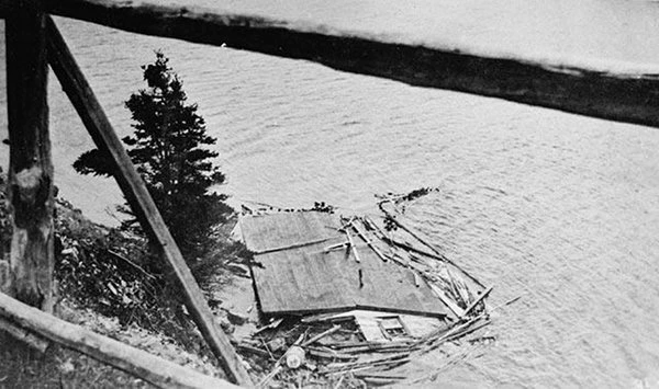
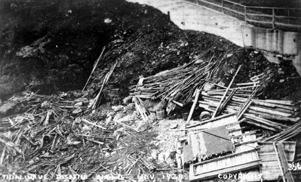
Destroyed remnants of coastal homes, businesses, wharfs and fishing gear. Credit: Provincial Archives, Government of Newfoundland and Labrador
The earthquake occurred about 280 km (174 miles) south of the Burin Peninsula at a depth of about 20 km (12 miles). Maximum shaking intensity reached Rossi–Forel VI based on felt reports collected across eastern Canada and the northeastern United States.
People felt the shock across a vast area, including reports from Montreal and New York City. On land, the strongest localized effects occurred in Cape Breton Island, where chimneys fell or cracked, and minor landslides temporarily blocked some road sections.
Aftershocks followed the main event, including one estimated at approximately M6. None caused major additional damage, but they were widely felt in Nova Scotia and Newfoundland.
At the time, shaking intensity values were gathered through questionnaires mailed to local postmasters by Canada’s Dominion Observatory. These reports took weeks to arrive and months to compile. By contrast, modern online reporting systems can produce comparable intensity maps within one or two days.
The Grand Banks slope was covered by thick layers of glacially derived sediments deposited during repeated Pleistocene advances. These sediments were mechanically weak, and the earthquake shaking destabilized them, setting up one of the largest documented submarine slumps in the North Atlantic.

Submarine landslide and turbidity current mechanics
The earthquake triggered a large submarine slump involving an estimated 200 km³ (48 mi³) of material. As the mass failed, it accelerated downslope and evolved into a turbidity current, entraining additional sediment and water as it traveled across the Sohm Abyssal Plain.
During its movement, the slump and turbidity current ruptured 12 trans-Atlantic telegraph cables. The sequence of breaks provided crucial time-stamped data that allowed researchers, most notably Heezen and Ewing in the 1950s, to reconstruct the flow’s velocity and progression across the seafloor.
Cable timing indicated minimum velocities of about 67 km/h (42 mph) over parts of the upper fan. Later models have reproduced the event using flow speeds in the range of 60–100 km/h (37–62 mph). This is one of the few turbidity currents in history documented with such temporal precision.
The tsunami generated by the slump was recorded far beyond Newfoundland. Disturbances appeared on tide gauges along the U.S. East Coast and were reported as far south as South Carolina, with additional recordings in Bermuda, the Azores, and Portugal.
Tsunami generation and propagation
The tsunami originated primarily from the displacement of water by the submarine slump and turbidity current, rather than from seafloor uplift. The mass movement imparted momentum into the overlying water column, generating long-period waves that propagated outward across the Atlantic.
The tsunami reached the Burin Peninsula about 2 hours and 20 minutes after the earthquake. Residents reported three principal pulses, with each surge reaching farther inland.
Along exposed sections of coast, water levels rose between 2–7 m (7–23 feet). In narrow, steep-sided inlets, the waves reached 13 m (43 feet), amplifying destruction through funneling and resonance effects.
Far-field arrivals recorded in Halifax, Bermuda, the Azores, and Portugal show their broad trans-oceanic reach. Disturbances registered along parts of the U.S. eastern seaboard, with accounts extending to South Carolina.
Impacts on coastal communities
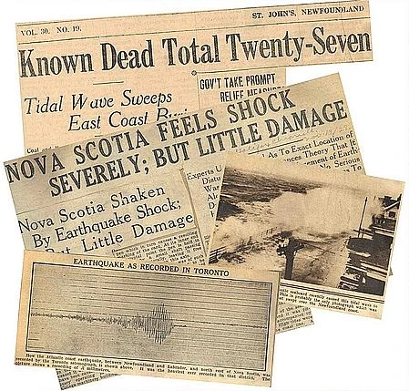
The tsunami devastated more than 40 communities on the Burin Peninsula. Twenty-eight people died: 27 drowned during the waves, and one victim succumbed to injuries in 1933. This event represents Canada’s largest documented loss of life directly related to an earthquake.
Entire houses were swept away, vessels destroyed, and wharves torn from their pilings. More than 280 000 pounds of salt cod were lost, a major economic blow to fishing families. Direct property losses exceeded one million dollars in 1929, a sum often estimated at nearly 20 million dollars in 2004 terms, depending on inflation conversion.
Some buildings were floated inland rather than demolished. A general merchandise store measuring 9–17 m (30–56 feet) was carried 60 m (197 feet) inland and set down intact in a meadow with its goods still arranged on the shelves.
Rescuers navigating by boat found survivors clinging to debris or trapped in drifting homes. One team located a sleeping baby whose family had drowned below. A man swept out to sea, swam to a floating house, only to realize it was his own. His home was later towed ashore and placed back on its foundation.
The tsunami also disturbed sections of the seafloor. Many fishers believed this contributed to prolonged poor catches during the Great Depression. The bait-fish collapse involving herring, squid, and capelin is documented, but scientific attribution to the tsunami remains uncertain.
A winter storm arrived the day after the tsunami, worsening conditions for survivors. The region’s only telegraph line had gone out of service just before the earthquake, delaying communication. Relief reached the area once word finally got out. The S. S. Meigle departed St. John’s and arrived on November 22, 1929, with government officials, doctors, and nurses. Additional aid came from the Red Cross and from British and American authorities.
Eyewitness account: Dr. Mosdell aboard the S.S. Meigle
(St. John’s Daily News, November 27, 1929 — “Lost At Sea”)
“Dwelling houses were reduced to a condition reminiscent of wartime description of the effects of heavy shell fire. Former sites of gardens and meadows now thickly strewn with boulders, some of them as large as casks thrown upon the shore by the devastating force of the tidal wave. Motor boats, stages and wharfs piers lifted bodily and thrown far inland in heaps of ruins. Lord’s Cove and Lamaline visited by the relief expedition yesterday here dozen of houses, stores and stages were found thrown bodily into the pond at the head of the harbors, huddled together in one heap of destruction. Some lay upright but half submerged while others lay on their sides, and still others were entirely overturned.”
This firsthand description remains one of the most vivid contemporary accounts of the tsunami’s devastation.
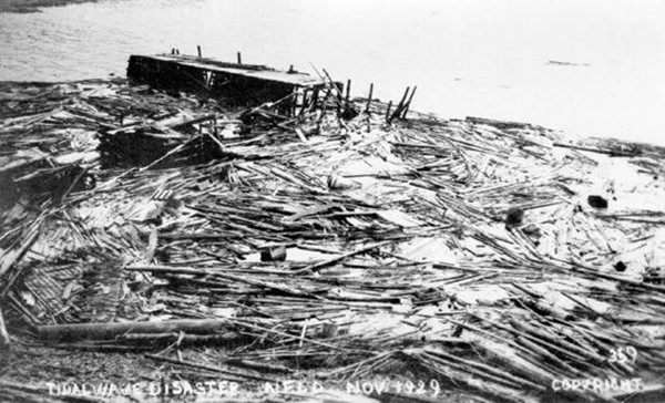
 Destroyed remnants of coastal homes, businesses, wharfs and fishing gear. Credit: Provincial Archives, Government of Newfoundland and Labrador
- Destroyed remnants of coastal homes, businesses, wharfs and fishing gear. Credit: Provincial Archives, Government of Newfoundland and Labrador
- Destroyed remnants of coastal homes, businesses, wharfs and fishing gear. Credit: Provincial Archives, Government of Newfoundland and Labrador

Scientific legacy and continuing research
The 1929 Grand Banks event is now a foundational case in the study of submarine landslides and landslide-generated tsunamis. The cable-break sequence documented by Heezen and Ewing provided the first clear evidence of a long-runout turbidity current triggered by an earthquake.
Later analyses by Fine and others, and recent modelling studies by Løvholt and Nakagaki, continue to refine estimates of slide geometry, rheology, and tsunami generation. The event demonstrated that sediment-rich continental margins can generate destructive tsunamis even without major fault displacement.
Final reflections
Nearly a century later, the 1929 Grand Banks earthquake and tsunami remain Canada’s most destructive tsunami on record and one of the most scientifically influential submarine mass-failure events ever documented. Its combination of offshore earthquake, large slump, turbidity current, and trans-oceanic tsunami propagation continues to guide hazard assessments for continental margins worldwide.
References:
1 The 1929 Magnitude 7.2 “Grand Banks” earthquake and tsunami – Earthquakes Canada – Accessed December 12, 2025

I’m a science journalist and researcher at The Watchers, contributing to the Epicenter edition, where I cover peer-reviewed scientific research and emerging discoveries across Earth and space sciences. With a background in astronomy and a passion for environmental science, I’ve worked in shark and coral conservation in Fiji, conducting reef and shark-behavior research, contributing to mangrove restoration, and earning PADI Open Water and Coral Reef Certifications. I bring a blend of scientific rigor and storytelling to illuminate the discoveries shaping our planet and beyond.
Commenting rules and guidelines
We value the thoughts and opinions of our readers and welcome healthy discussions on our website. In order to maintain a respectful and positive community, we ask that all commenters follow these rules.