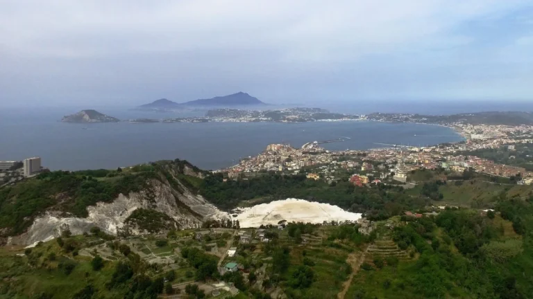
• The science behind Alberta Clippers and their role in shaping North American winters

    An Alberta Clipper is a compact and fast moving winter cyclone that forms east of the Canadian Rockies and races across the northern United States and southern Canada, often bringing sharp temperature drops, strong winds, and brief but disruptive snowfall.

  • Central Himalayan seismic gap shows centuries of stored strain capable of two M8.8 events

    New geodetic measurements along an 800 km (500 miles) section of the Himalayas indicate that seven centuries of accumulated strain may be enough to produce two M8.8 earthquakes, according to a study published recently in Geophysical Research Letters.

  • HKU researchers uncover new tectonic regime reshaping our understanding of Earth and Venus

    Scientists at the University of Hong Kong (HKU) have identified a previously unknown tectonic regime, the “episodic-squishy lid”, redefining how terrestrial planets evolve and offering new insights into the tectonic histories of Earth and Venus.

  • Earthquake swarms signal hidden shifts beneath the crust

    Earthquake swarms are sequences of many small to moderate earthquakes that cluster in time and space without producing a single defining mainshock. Their unusual patterns reveal how stress, fluids and magma shift through the crust, offering one of the clearest signals that the Earth is actively reshaping itself beneath our feet.

  • Seasonal microfractures beneath Alaska’s Barry Arm reveal hidden instability signals

    Short, high-frequency seismic signals recorded between 2020 and 2023 beneath Cascade Glacier in Alaska’s Barry Arm display a recurring seasonal cycle that may reflect freeze-thaw cracking in subsurface rock. The study, published on December 2, 2025, in Seismological Research Letters, provides new insight into processes that influence one of the most dangerous landslide hazards in the United States.

  • Lahars reshape landscapes and redefine volcanic danger worldwide

    Lahars are rapid volcanic mudflows capable of traveling tens of kilometers down valleys with little warning, moving at speeds of up to 65 km/h (40 mph) and carrying trees, boulders, and buildings. They form when water mixes with volcanic ash and rock during eruptions, heavy rainfall, or crater-lake breaches, creating a dense flow that can bury settlements, reshape river systems, and alter landscapes long after volcanic activity ends.

  • Rogue lightning and what it tells us about explosive eruptions

    Volcanic eruptions can generate spectacular “rogue lightning,” as ash-filled plumes become electrically charged and discharge massive bolts, the U.S. Geological Survey (USGS) and National Oceanic and Atmospheric Administration (NOAA) report. Lightning detection networks have helped identify eruptions within second, a critical tool for aviation and hazard monitoring.

  • Strongest hurricane wind ever measured confirmed in Hurricane Melissa

    A NOAA dropsonde released into Hurricane Melissa near Jamaica on October 28, 2025, recorded a wind gust of 406 km/h (252 mph), later verified by the U.S. National Science Foundation National Center for Atmospheric Research as the strongest hurricane wind speed ever measured by a dropsonde.