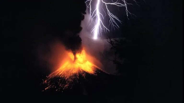
• What are atmospheric rivers and how they shape regional flood patterns

    Atmospheric rivers are long, narrow corridors of concentrated water vapor that move through the atmosphere and deliver massive amounts of rain and snow to mid-latitude coasts. These “rivers in the sky” shape flood seasons in the U.S. West Coast and Europe and are closely monitored because their intensity, duration and landfall location determine whether they bring beneficial moisture or trigger destructive floods.

  • How the polar vortex shapes winter weather across the mid-latitudes

    A polar vortex is a rotating mass of cold, dense air in the winter stratosphere, extending vertically from about 10–15 km (6.2–9.3 miles) to 50 km (31 miles) altitude and typically monitored at levels like 10 hPa at roughly 30 km (18.6 miles) above the surface. Its strength and shape influence the jet stream, altering the probability of cold-air outbreaks across North America and Europe for several weeks after major disturbances.

  • Main driver of Sargassum blooms in the Atlantic Ocean revealed

    A new study from the Max Planck Institute for Chemistry identifies equatorial upwelling of phosphorus-rich deep water as the primary driver behind the record Sargassum blooms affecting the Caribbean, Gulf of Mexico, and northern South America. Researchers show that this nutrient supply strengthens nitrogen fixing cyanobacteria living on Sargassum, giving the algae a competitive advantage that has intensified since 2011 and contributed to a new negative record of biomass this year.

  • Why tropical cyclone survivors keep dying weeks after the storm ends

    A global study spanning 217 tropical cyclones and 14.8 million deaths across nine countries has found that people continue dying for weeks after storms end. The most common post-cyclone deaths are from kidney and metabolic diseases, not injuries, revealing a silent global health crisis in the wake of extreme weather.

  • Ground collapses across Arizona’s Willcox Basin as decades of groundwater pumping take their toll

    Satellite data show the ground is sinking by as much as 15 cm (6 inches) per year in Arizona’s Willcox Basin, the fastest rate in the state. Scientists say decades of groundwater extraction for irrigation have permanently compacted the land.

  • Hidden magma body beneath Mayotte revealed by electromagnetic imaging

    A new Nature study reveals a massive, melt-rich magma body beneath Mayotte at 23 ±1 km (14 ±0.6 miles) below sea level, estimated to hold over 200 km³ (48 miles³) of material containing 22–42% melt. This reservoir is possibly connected to the system that fed the large submarine eruption of Fani Maoré in 2018–2019.

  • North American ice sheets drove the final surge in sea-level rise at the end of the last deglaciation

    Between about 9 000 and 7 000 years ago, global sea level climbed roughly 14 meters (46 feet), mostly from the collapse of North American ice sheets, according to new research in Nature Geoscience by Udita Mukherjee and colleagues.