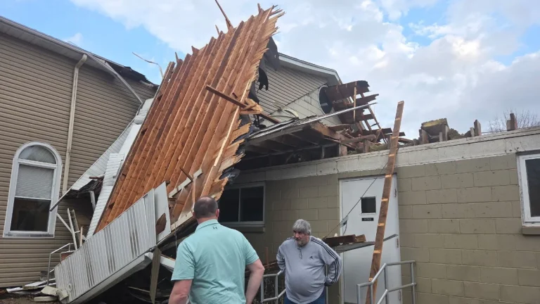
• Watertown drops to -38°C (-36°F) as Arctic air grips Upstate New York

    An intense Arctic cold outbreak drove temperatures well below seasonal norms across Upstate New York on Sunday, February 8, 2026, with Watertown reaching −38°C (−36°F) at the airport. Several other communities matched or exceeded their lowest temperatures of the winter during the same period.

  • Pyroclastic density currents from Mayon volcano reach 4 km (2.5 miles), Philippines

    A series of collapse-fed pyroclastic density currents descended the Mi-isi Gully at Mayon volcano, Philippines, on February 9, 2026, with the farthest runout reaching 4 km (2.5 miles) from the summit crater. The activity peaked between 10:35–11:37 local time (LT), culminating in a seven-minute event at 10:59 LT that generated ash clouds exceeding 2 km (about 6 560 feet) in height and causing ashfall across parts of Camalig and Guinobatan, Albay, during rainy conditions.

  • Hydrothermal unrest persists at El Chichón volcano, Mexico

    Hydrothermal unrest at El Chichón volcano in northern Chiapas, Mexico, has persisted since mid-2025, characterized by elevated seismicity, chemical-physical changes in the crater lake, and increased gas emissions. National and academic monitoring institutions report no evidence of magma ascent, and current conditions do not indicate an imminent eruption. The volcano remains at Yellow Alert.

  • Beneficial Sierra Nevada snowfall expected as weak atmospheric river moves through California

    A short-duration atmospheric river is forecast to impact California from Tuesday, February 10, through Thursday, February 12, 2026, bringing low-elevation rainfall and significant snowfall at higher elevations, particularly across the Sierra Nevada. Forecast guidance indicates the event will be short-lived, with impacts expected to be largely beneficial for regional snowpack rather than flood-producing.

  • Valentine’s Day weekend storm to bring widespread heavy rain to the southern United States

    A developing storm system is forecast to bring widespread rain and thunderstorms to the south-central and southeastern United States from Friday, February 13, 2026, through Valentine’s Day weekend, with localized flooding possible where heavier rainfall occurs. The system is expected to track eastward from the Plains into the lower Mississippi Valley and Southeast between February 13 and February 15, affecting travel and outdoor activities across a large portion of the region.

  • Major storm hits Hawaii with damaging winds and extreme rainfall, causing widespread power outages

    A powerful storm system impacted Hawaii between February 8 and 10, 2026, producing heavy rainfall, flash flooding, landslides, and damaging winds. Wind gusts frequently exceeded 95 km/h (60 mph), with localized gusts approaching 115 km/h (70 mph), leading to road closures, including along Maui’s Hāna Highway, downed trees, and intermittent power outages affecting tens of thousands of customers on Oʻahu, Maui, and Hawaiʻi Island.