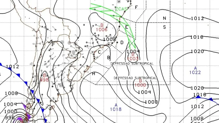
• La Niña breakdown underway as models point to ENSO-neutral conditions in early 2026

    La Niña conditions in the equatorial Pacific show signs of a transition toward ENSO-neutral conditions, with potential for El Niño development later in 2026. Observations from the National Oceanic and Atmospheric Administration (NOAA) and the European Centre for Medium-Range Weather Forecasts (ECMWF) show subsurface ocean warming and westerly wind anomalies across the central Pacific, indicating the breakdown of the three-year La Niña phase.

  • Santa Ana winds bring damaging gusts up to 70 mph, elevate fire weather concerns across Southern California

    Strong Santa Ana winds intensified across Southern California on Friday, January 9, 2026, prompting the National Weather Service to issue high wind warnings and advisories for mountain, valley, and coastal regions. Gusts reaching up to 115 km/h (70 mph) were recorded in canyon and foothill areas, raising risks of power outages, tree damage, and hazardous travel conditions through the weekend.

  • State of Disaster declared for the first time since 2020 as bushfires destroy over 130 structures in Victoria, Australia

    A fast-moving bushfire crisis has prompted the Victorian Government to declare a State of Disaster for the first time since 2020, on January 10, 2026, with over 300 000 ha (741 000 acres) being scorched across the state under extreme heat and high winds. At least 130 structures have been destroyed, and thousands remain under evacuation orders, with conditions forecast to remain dangerous in the coming days.

  • Remnant Alaska atmospheric river to merge with second plume, bringing prolonged AR conditions to western Washington

    An atmospheric river that impacted Alaska on January 9, 2026, is forecast to propagate down the coast and merge with a second plume, delivering a 48–72-hour period of AR conditions over western Washington from January 10 to 12. Forecast guidance indicates 100–150 mm (4–6 inches) of rain over the Olympic Peninsula, 50–100 mm (2–4 inches) over the northern Washington Cascades, and 25–50 mm (1–2 inches) over the Cascade foothills, with freezing levels rising above 1 830 m (6 000 feet).

  • Tornadoes touch down in Mississippi as severe storms sweep across the state

    Multiple tornadoes touched down in Mississippi on January 9, 2026, as a powerful storm system moved through the Deep South, producing damaging winds and heavy rainfall. The U.S. National Weather Service issued Tornado and Flash Flood Watches for large portions of the state, warning of further severe storms through January 10 as the system continues eastward.