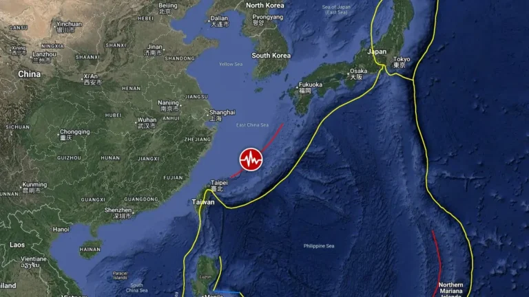
• Severe storms continue from the Adriatic into the Balkans, Level 2 risk shifts toward Bulgaria, Romania and NW Turkey

    Severe thunderstorms continued across parts of northern Italy, Slovenia, Croatia, and the western Balkans on Monday, May 11, 2026. ESTOFEX forecasters warn the severe weather corridor is expected to shift east on Tuesday, with Level 2 risk areas extending from southeastern Romania through Bulgaria into northeastern Greece and northwestern Turkey. Large hail, localized heavy rainfall, and severe wind gusts remain the primary hazards.

  • SPC warns of Critical fire weather conditions across eastern Montana and west-central North Dakota

    The NWS Storm Prediction Center (SPC) issued a Critical fire weather forecast for parts of eastern Montana into west-central North Dakota valid from 12:00 UTC on May 11 through 12:00 UTC on May 12, 2026, as multiple National Weather Service offices warned that strong winds, low humidity, dry fuels, and frontal wind shifts would support rapid wildfire spread across parts of the northern and central Plains.

  • Massive wildfire burns through Chernobyl exclusion zone following UAV crash in Ukraine

    A massive forest fire broke out in Ukraine’s Chernobyl exclusion zone on May 7, 2026, following the crash of two drones and has spread across approximately 1 200 ha (2 965 acres), according to the Chornobyl Radiation and Ecological Biosphere Reserve (CREBR). While the fire situation is under control as of May 9, the threat of landmines in the area coupled with strong winds and dry air continues to complicate suppression efforts.

  • Increased seismicity and gas emissions at Kupreanof volcano, Alaska

    Seismic activity and sulfur dioxide emissions have increased at Kupreanof volcano in Alaska over recent months, likely due to magmatic intrusion beneath the volcano. Kupreanof is a heavily glaciated stratovolcano on the Alaska Peninsula with no known historical eruptions. Current data do not indicate an eruption is imminent.

  • Enhanced Risk issued for large hail and severe wind gusts in parts of north and central Texas

    An Enhanced Risk (level 3/5) for severe thunderstorms has been issued across parts of west-central and north-central Texas through May 10, 2026. Supercells capable of producing hailstones larger than 5 cm (2 inches) and wind gusts above 113 km/h (70 mph) are forecast to develop during the afternoon and evening hours. The severe-weather threat extends east-northeastward into the Ark-La-Tex region and parts of the lower Mississippi Valley.

  • NWS confirms long-track EF3 tornado in Mississippi outbreak

    The National Weather Service office in Jackson, Mississippi, determined after additional damage surveys that two EF3 tornado tracks documented during the May 6-7, 2026 severe weather outbreak were part of one continuous long-track tornado. Survey teams also confirmed an EF2 tornado near Purvis in Lamar County as assessments continued across southern Mississippi.

  • Tropical Storm Hagupit moves through Yap State, expected to enter PAR as Caloy

    Tropical Storm Hagupit was moving west through Yap State at 22:00 ChST (12:00 UTC) on May 8, 2026, with maximum sustained winds of 70 km/h (45 mph). Tropical Storm Warnings remained in effect for Ulithi, Ngulu, Fais, Yap Proper, and adjacent coastal waters. PAGASA expects the system to enter the Philippine Area of Responsibility on May 9 and be named Caloy.

  • Repeated lava-collapse pyroclastic flows continue at Mayon volcano, Philippines

    Mayon volcano remained under Alert Level 3 on Friday, May 8, 2026, with PHIVOLCS reporting lava flows in three gullies, elevated sulfur dioxide emissions, volcanic earthquakes, and repeated lava-collapse pyroclastic flow activity. Today’s observations follow a large eruption sequence on May 2, when collapse-generated pyroclastic flows traveled up to 5 km (3.1 miles), generating widespread ashfall across parts of Albay Province and prompting evacuations affecting thousands of residents.