
Subtropical Storm Josephine forms off U.S. East Coast, forecast to become a hurricane-force extratropical cyclone
Subtropical Storm Josephine was accelerating northeastward away from the U.S. East Coast at 05:00 AST (09:00 UTC) on October 22, 2026, with maximum sustained winds of 100 km/h (65 mph). The National Hurricane Center forecast Josephine to lose its subtropical characteristics later October 22 or overnight into October 23 while strengthening through interaction with an approaching upper-level trough, becoming a hurricane-force extratropical cyclone within 24 hours.
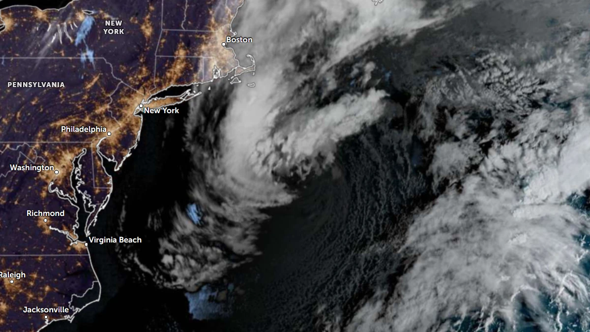
Satellite image of subtropical storm Josephine at 11:40 UTC on October 22, 2026. Credit: NOAA/GOES-19, Zoom Earth, The Watchers
Josephine formed at 17:00 AST (21:00 UTC) on October 21 from the non-tropical low designated AL93. At formation, its center was located about 425 km (265 miles) south of Nantucket, Massachusetts, and 940 km (585 miles) southwest of Halifax, Nova Scotia.
Maximum sustained winds at formation were 100 km/h (65 mph), and the estimated minimum central pressure was 990 hPa.
The National Hurricane Center (NHC) initiated advisories after scatterometer data showed that nearby fronts had dissipated and the radius of maximum wind had decreased. Moderate-to-deep convection was organizing near and west of the system’s warm-core center.
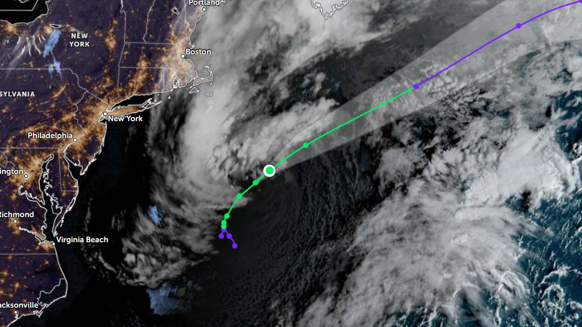
At 05:00 AST (09:00 UTC) on October 22, Josephine was centered about 315 km (195 miles) south-southeast of Nantucket and 765 km (475 miles) south-southwest of Halifax.
The cyclone was moving northeast at 20 km/h (13 mph). Maximum sustained winds remained at 100 km/h (65 mph), while the minimum central pressure had fallen to 988 hPa.
NHC had no tropical cyclone coastal watches or warnings in effect. Local National Weather Service coastal, surf and marine products remained active for hazards associated with the storm’s broad circulation.
Satellite imagery ahead of the 09:00 UTC advisory showed renewed convection over the northern and western parts of Josephine. A Metop-C scatterometer pass indicated a large, asymmetric wind field, including a band of approximately 83–93 km/h (52–58 mph) winds wrapping around the western side of the circulation.
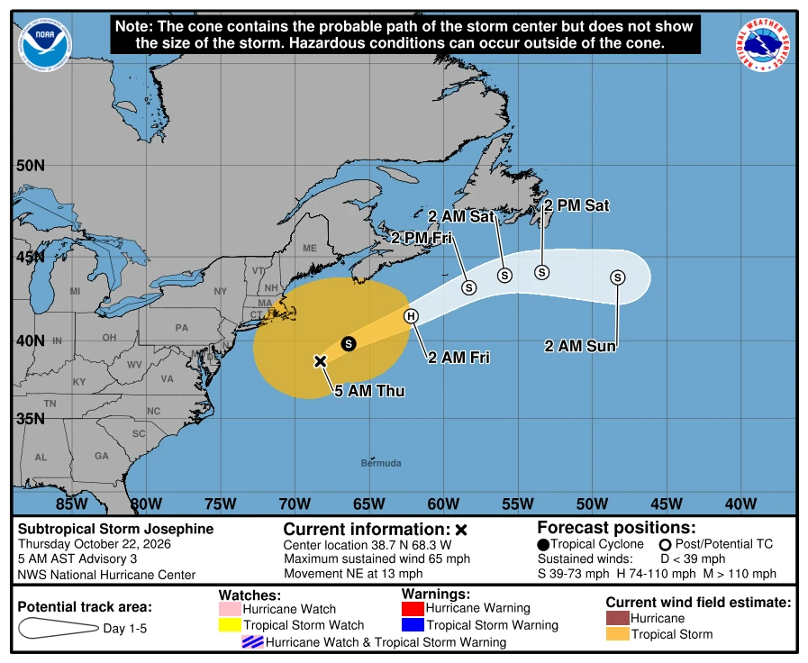
The radius of maximum wind was about 110 km (70 miles). Winds of at least 65 km/h (40 mph) extended as far as 665 km (415 miles) from the center.
Josephine was expected to accelerate northeastward and then east-northeastward on October 22 as a potent upper-level trough moved southeastward from Quebec toward the Canadian Maritimes and the northeastern United States.
NHC expected the trough to amplify and close off over the North Atlantic by early October 23, steering Josephine eastward well south of Newfoundland.
Josephine is forecast to lose its subtropical structure over colder water while interacting with the approaching trough. Baroclinic processes are expected to strengthen the system during that transition.
NHC forecast Josephine to strengthen to about 110 km/h (70 mph) later on October 22 before becoming a hurricane-force extratropical cyclone with maximum winds near 130 km/h (80 mph) at 02:00 AST (06:00 UTC) on October 23.
Gradual weakening is forecast afterward as the system moves eastward across the North Atlantic. Josephine is expected to dissipate by October 26 as it is absorbed into a larger mid-latitude system.
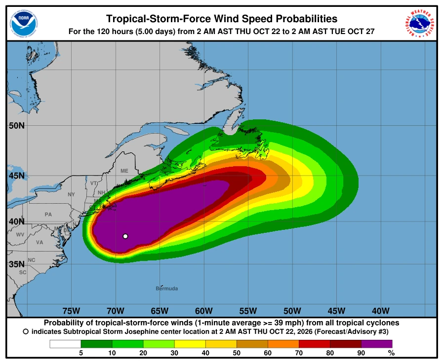
NHC said gale-force gusts were possible along portions of the northeastern U.S. coast through October 22. Minor to locally moderate coastal flooding was continuing along parts of the Mid-Atlantic coast and was expected to persist around high tides through the rest of the week.
Large swells generated by Josephine were affecting much of the eastern seaboard of the United States and portions of Atlantic Canada. NHC warned that the swells were producing life-threatening surf and rip-current conditions.
Josephine formed during the latter part of the Atlantic hurricane season, which continues through November 30. Its subtropical phase is forecast to be brief: the system developed from a non-tropical low, acquired a warm-core subtropical structure and is expected to return to an extratropical configuration while strengthening.
References:
1 Subtropical Storm Josephine Public Advisory Number 3 – NOAA/NHC – October 22, 2026
2 Subtropical Storm Josephine Forecast Discussion Number 3 – NOAA/NHC – October 22, 2026

Rishav Kothari is Editor-in-Chief of The Watchers, where he runs the newsroom and covers earthquakes, volcanoes, severe weather and space weather.
Published in the last 24 hours
- In April 2014, golden-winged warblers in the mountains of Tennessee, songbirds weighing about as much as four dimes, fled their breeding grounds a day or two before a tornado outbreak and flew hundreds of miles south, while the scientists tracking them sheltered in a Waffle House Epicenter
- After record Nordic heatwave, Swedish researchers to recreate indoor heat to study older adults Epicenter
- San Juan River cuts through 300-million-year-old rocks while retaining its winding course in Utah Epicenter
- Britain appointed a Minister for Drought in August 1976, and it rained so much afterward that by November MPs were calling him the Minister of Flood Epicenter
