
Severe weather outbreak expected March 4 in Lower Mississippi Valley and Mid-South
A powerful storm is forecast to sweep through the central U.S., bringing in severe weather through mid-week as it moves from the Southern and Central Plains to the Great Lakes Region from Monday through Wednesday, March 3–6, 2025. A more significant severe weather outbreak is expected on Tuesday, March 4, in the Lower Mississippi Valley and Mid-South, with threats of strong winds, large hail, and possible tornadoes. The Storm Prediction Center has issued a Slight Risk (level 2 of 5) for parts of the Southern Plains today, while an Enhanced Risk (level 3 of 5) is in place for Tuesday and Wednesday across the Lower Mississippi Valley.
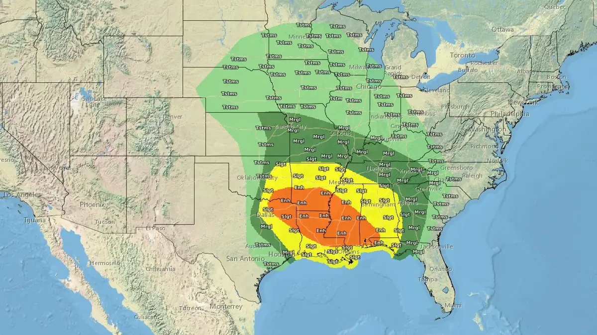
Convective outlook for Tuesday, March 4, 2025. Credit: NWS, The Watchers
A low-pressure system is expected to rapidly strengthen as it tracks across the Southern and Central Plains on March 3. The system will continue through the Midwest on March 4 before reaching the Great Lakes region on March 5.
The storm will bring widespread severe weather through midweek, initially producing 15–30 cm (6–12 inches) of fresh snow in the Sierra Nevada and 30–60 cm (1–2 feet) of snow in higher elevations of the Great Basin and Central Rockies through March 5.
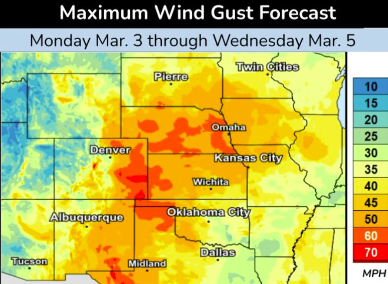
Heavy snow and strong winds are expected to develop from the central High Plains to the Upper Midwest on March 5–6 within the storm’s cold sector.
The system will produce widespread snow accumulations of 10–20 cm (4–8 inches), with localized totals reaching 30 cm (12 inches) in the Upper Midwest. Blizzard conditions are likely in affected areas.
Winds reaching 130 km/h (80 mph) combined with heavy snowfall will create hazardous travel conditions, reducing visibility to whiteout levels in some areas. “There is no safe place on a highway during a blizzard,” stated the National Weather Service (NWS).
Severe thunderstorms and heavy rainfall are the main concerns for much of the Southern Plains, Mid-South, and Lower Mississippi Valley. Strong winds will transport Gulf moisture and instability northward, supporting heavy showers and thunderstorms across the Southern Plains, including the Red River Valley of the South.
A more widespread and potentially significant severe weather outbreak is expected on Tuesday, March 4 in the Lower Mississippi Valley and Mid-South region, with threats including strong damaging winds, large hail, and possible tornadoes. The Storm Prediction Center has issued a Slight Risk (level 2 of 5) for portions of the Southern Plains today, with an Enhanced Risk (level 3 of 5) forecast for Tuesday and Wednesday across the Lower Mississippi Valley. The Weather Prediction Center has also indicated a Slight Risk (level 2 of 4) of excessive rainfall for parts of these regions, overlapping some of the severe weather threat areas.
This strong winter storm will significantly impact temperatures through at least midweek. Well-above seasonal average temperatures are expected from the Midwest to the East on Tuesday and Wednesday, as these areas will remain on the warm side of the approaching system. Meanwhile, below-normal temperatures in the West will spread into the Plains as the storm system moves eastward.
In the aftermath of the storm, drier air and strong winds will spread across the central and southern High Plains and parts of the Southwest, reducing humidity and elevating wildfire risks.
Critical to extreme fire weather conditions will persist, particularly in eastern New Mexico and western Texas on March 5–6, with the potential for dust storms. Power outages may occur due to downed power lines and trees in affected areas.
References:
1 Short Range Forecast Discussion – NWS/WPC – March 3, 2025

I am an Assistant Editor and Severe Weather & Science Journalist at The Watchers, specializing in real-time severe weather coverage, geophysical event reporting, and research-driven scientific analysis. You can reach me at rishav(at)watchers(.)news.
Commenting rules and guidelines
We value the thoughts and opinions of our readers and welcome healthy discussions on our website. In order to maintain a respectful and positive community, we ask that all commenters follow these rules.