
Severe thunderstorms forecast to impact Great Plains, Ohio Valley, and Southeast US next week
A powerful storm system is expected to develop over the east-central Great Plains and lower Great Lakes region by late Tuesday, March 4, 2025, bringing a risk of severe thunderstorms, strong tornadoes, hail, and damaging winds.

Image credit: DerTobiSturmjagd
A powerful storm system is expected to develop over the east-central Great Plains and lower Great Lakes region by late Tuesday, March 4.
The system will develop as a shortwave trough moves from the Pacific coast into the southern Rockies by early Monday, continuing east-northeast through the week. This trough will create conditions favorable for severe weather across the southeastern Great Plains, Ohio Valley, and Southeast.
High wind shear and moist air could lead to severe thunderstorms, including strong tornadoes and damaging wind gusts in the affected regions.
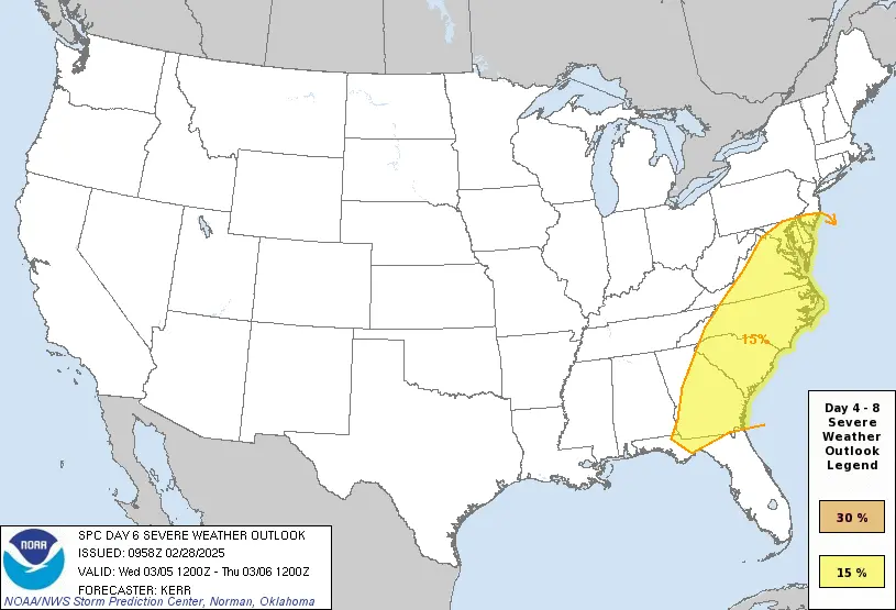
The specific impact locations remain uncertain. However, the severe weather risk could extend into parts of the southern and mid-Atlantic regions on Wednesday, March 5.
A cold front is expected to move through parts of the East, particularly from Delaware and Maryland to far northern Florida, bringing the potential for damaging winds and a few tornadoes on Wednesday.
The NOAA Storm Prediction Center (SPC) highlighted parts of the South, from Texas to the Tennessee Valley and Ohio Valley, as areas at risk for severe thunderstorms on Tuesday and Tuesday night.
While the SPC occasionally highlights areas in its extended outlook where severe thunderstorms are possible, it is uncommon for them to specify a likely area of severe threat this far in advance. This suggests a heightened potential for a more widespread outbreak of severe thunderstorms.
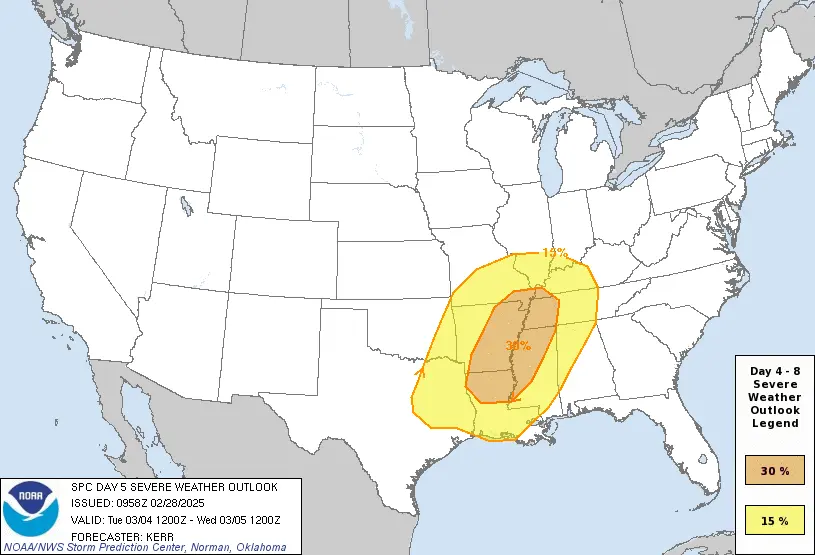
In its Friday morning outlook, the SPC stated there is “potential for a few strong tornadoes and damaging straight-line winds on Tuesday and Tuesday night.”
Locally heavy rainfall is possible in parts of the Ohio, Mississippi, and Tennessee Valleys, accompanied by the threat of severe thunderstorms. The heavy rain could trigger flash flooding in areas that experienced flooding earlier in February, particularly in Kentucky, Tennessee, Virginia, and West Virginia.
The system may generate areas of wet snow from the Plains into parts of the Great Lakes and Midwest from Monday night through Thursday, March 6.
Accumulating snow east of the Rockies is expected to be patchy due to insufficient cold air. However, some areas in the Great Lakes region could receive locally heavy snowfall.
References:
1 Day 4-8 Severe Weather Outlook – NOAA/SPC – February 28, 2025
2 A Severe Weather Outbreak Is Possible Next Week In The South, Including Tornadoes, Flooding Rain – TWC -February 28, 2025

I am an Assistant Editor and Severe Weather & Science Journalist at The Watchers, specializing in real-time severe weather coverage, geophysical event reporting, and research-driven scientific analysis. You can reach me at rishav(at)watchers(.)news.
Commenting rules and guidelines
We value the thoughts and opinions of our readers and welcome healthy discussions on our website. In order to maintain a respectful and positive community, we ask that all commenters follow these rules.